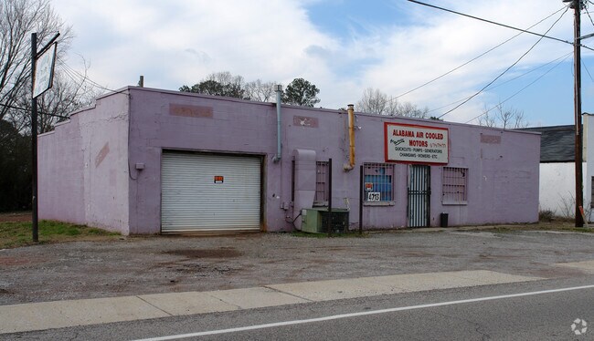
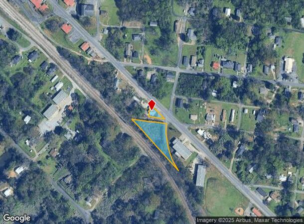
Property Record
4707 Main St, Adamsville, AL 35005

NEARBY LISTINGS FOR SALE OR LEASE
Property Detail
4707 Main St
Birmingham-Hoover, AL
Tutwiler Add To Adamsville
15-00-33-4-017-005.000
LOTS 10-11 BLK 15 S OF MAIN ST E M TUTWILERS ADD TO ADAMSVILLE ALSO LOTS 1 THRU 5 BLK 13 TUTWILERS ADD TO ADAMSVILLE SEC 33 TWSP 16S R4W
Storebuilding
Jefferson
X
Alabama
01073C0352H
9
2023
0.56 AC
2024
Bessemer
012104
Birmingham
1,763 SF
DEMOGRAPHICS near 4707 Main St
1 Mile
3 Mile
5 Mile
2024 Total Population
2,310
10,274
23,198
2029 Population
2,276
10,087
22,771
Pop Growth 2024-2029
(1.47%)
(1.82%)
(1.84%)
Average Age
41
42
42
2024 Total Households
893
4,078
9,279
HH Growth 2024-2029
(1.46%)
(1.89%)
(1.89%)
Median Household Inc
$36,764
$50,493
$52,092
Avg Household Size
2.50
2.40
2.40
2024 Avg HH Vehicles
2.00
2.00
2.00
Median Home Value
$126,621
$135,673
$132,411
Median Year Built
1966
1968
1969
Nearby Places
Map Layers
Map Styles
 Street
 Aerial
- Restaurants
- Banks
- Shops
- Fitness
- Groceries
PUBLIC TRANSPORTATION
AIRPORT
Birmingham-Shuttlesworth International
DRIVE
WALK
Distance
Birmingham-Shuttlesworth International
26 min
16.7 mi
Freight Ports
Port of Mobile
DRIVE
WALK
Distance
Port of Mobile
295 min
266.3 mi
Nearby Properties
Address
Land Use
TOTAL SIZE
Lot Size
Zoning
Address
Land Use
TOTAL SIZE
Lot Size
Zoning
181,399 SF
20.91 AC
A1
Address
Land Use
TOTAL SIZE
Lot Size
Zoning
137,177 SF
10 AC
INST
Address
Land Use
TOTAL SIZE
Lot Size
Zoning
45,716 SF
37 AC
I3
Address
Land Use
TOTAL SIZE
Lot Size
Zoning
31,438 SF
8 AC
B2
Address
Land Use
TOTAL SIZE
Lot Size
Zoning
26,458 SF
3.88 AC
INST
Address
Land Use
TOTAL SIZE
Lot Size
Zoning
111,145 SF
14 AC
R1
Address
Land Use
TOTAL SIZE
Lot Size
Zoning
48,001 SF
3.90 AC
B2
Address
Land Use
TOTAL SIZE
Lot Size
Zoning
37,100 SF
22.70 AC
INST
Address
Land Use
TOTAL SIZE
Lot Size
Zoning
29,928 SF
4.38 AC
INST
Address
Land Use
TOTAL SIZE
Lot Size
Zoning
25,417 SF
6.26 AC
B3
Address
Land Use
TOTAL SIZE
Lot Size
Zoning
1,200 SF
8.30 AC
A1
Address
Land Use
TOTAL SIZE
Lot Size
Zoning
30,693 SF
12 AC
INST
Address
Land Use
TOTAL SIZE
Lot Size
Zoning
24,566 SF
2 AC
R1
Address
Land Use
TOTAL SIZE
Lot Size
Zoning
16,300 SF
0.50 AC
R2
Address
Land Use
TOTAL SIZE
Lot Size
Zoning
22,850 SF
6.10 AC
BR
Address
Land Use
TOTAL SIZE
Lot Size
Zoning
15,732 SF
289 AC
I-3-
Address
Land Use
TOTAL SIZE
Lot Size
Zoning
34,592 SF
4.40 AC
B2
Address
Land Use
TOTAL SIZE
Lot Size
Zoning
16,581 SF
5.90 AC
C1
Address
Land Use
TOTAL SIZE
Lot Size
Zoning
17,352 SF
0.45 AC
I
Address
Land Use
TOTAL SIZE
Lot Size
Zoning
24,500 SF
1.70 AC
M1
Address
Land Use
TOTAL SIZE
Lot Size
Zoning
15,540 SF
1.62 AC
R4
Address
Land Use
TOTAL SIZE
Lot Size
Zoning
3,050 SF
5.50 AC
M2
Address
Land Use
TOTAL SIZE
Lot Size
Zoning
13,524 SF
1.78 AC
I3
Address
Land Use
TOTAL SIZE
Lot Size
Zoning
25,000 SF
0.70 AC
B-3
Address
Land Use
TOTAL SIZE
Lot Size
Zoning
3,526 SF
0.82 AC
B1
Address
Land Use
TOTAL SIZE
Lot Size
Zoning
15,116 SF
3 AC
M1
Address
Land Use
TOTAL SIZE
Lot Size
Zoning
6,687 SF
1.66 AC
C1
Address
Land Use
TOTAL SIZE
Lot Size
Zoning
5,733 SF
0.95 AC
R3
Address
Land Use
TOTAL SIZE
Lot Size
Zoning
12,800 SF
0.69 AC
R2
Address
Land Use
TOTAL SIZE
Lot Size
Zoning
27,360 SF
10.60 AC
M2
The World's #1 Commercial Real Estate Marketplace
Connect with us
© 2025 CoStar Group
The information above has been obtained from sources believed reliable. While we do not doubt its accuracy we have not verified it and make no guarantee, warranty or representation about it. It is your responsibility to independently confirm its accuracy and completeness. Any projections, opinions, assumptions, or estimates used are for example only and do not represent the current or future performance of the property. The value of this transaction to you depends on tax and other factors which should be evaluated by your tax, financial, and legal advisors. You and your advisors should conduct a careful, independent investigation of the property to determine to your satisfaction the suitability of the property for your needs.