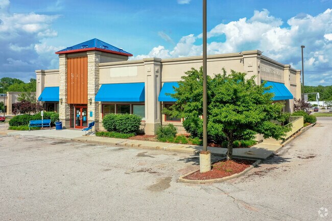
Property Record
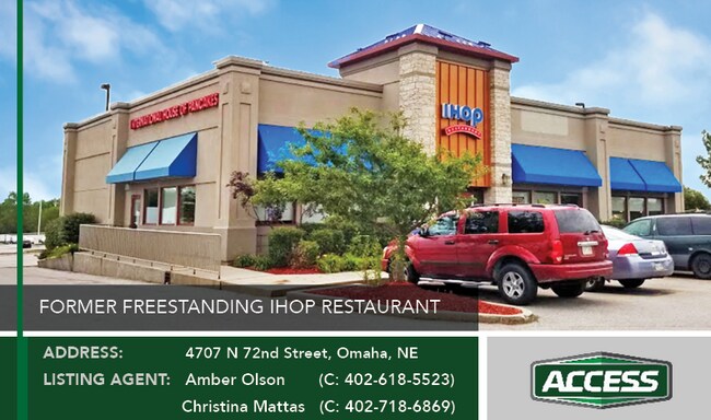
4707 N 72Nd St, Omaha, NE 68134

NEARBY LISTINGS FOR SALE OR LEASE
Property Detail
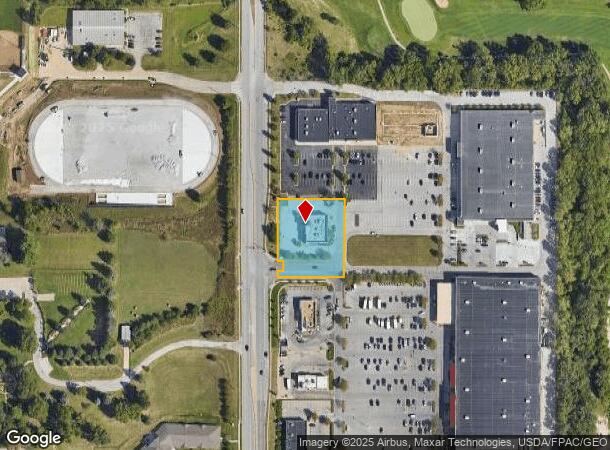
4707 N 72Nd St
Omaha-Council Bluffs, NE-IA
Benson Park Plaza
3654-0179-06
BENSON PARK PLAZA REP 1 LOT 5 BLOCK 0 LT 5 IRR 1.03 AC
Restaurantbuilding
Douglas
X
Nebraska
31055C0217H
5
2024
1.01 AC
2025
Northeast Omaha
005600
Omaha/Council Bluffs
4,945 SF
DEMOGRAPHICS near 4707 N 72Nd St
1 Mile
3 Mile
5 Mile
2024 Total Population
11,080
107,946
244,884
2029 Population
11,357
109,465
249,210
Pop Growth 2024-2029
+ 2.50%
+ 1.41%
+ 1.77%
Average Age
39
37
37
2024 Total Households
4,307
42,880
101,265
HH Growth 2024-2029
+ 2.90%
+ 1.45%
+ 1.83%
Median Household Inc
$52,064
$57,730
$56,591
Avg Household Size
2.40
2.40
2.30
2024 Avg HH Vehicles
2.00
2.00
2.00
Median Home Value
$164,207
$168,231
$183,249
Median Year Built
1965
1964
1966
Nearby Places
Map Layers
Map Styles
 Street
 Aerial
- Restaurants
- Banks
- Shops
- Fitness
- Groceries
PUBLIC TRANSPORTATION
COMMUTER RAIL
DRIVE
WALK
Distance
17 min
8.5 mi
DRIVE
WALK
Distance
16 min
8.8 mi
AIRPORT
Eppley Airfield
DRIVE
WALK
Distance
Eppley Airfield
18 min
8.8 mi
SALE & LEASE HISTORY
LISTING DATE
SALE/LEASE

Oct 03, 2023
For Lease
Oct 03, 2023
For Sale
Jul 05, 2023
For Sale
Apr 18, 2022
For Lease
Apr 08, 2020
For Sale
Nearby Properties
Address
Land Use
TOTAL SIZE
Lot Size
Zoning
Address
Land Use
TOTAL SIZE
Lot Size
Zoning
702,563 SF
18.85 AC
Address
Land Use
TOTAL SIZE
Lot Size
Zoning
548,510 SF
36.78 AC
Address
Land Use
TOTAL SIZE
Lot Size
Zoning
141,816 SF
24.91 AC
Address
Land Use
TOTAL SIZE
Lot Size
Zoning
420,264 SF
23.97 AC
R6
Address
Land Use
TOTAL SIZE
Lot Size
Zoning
255,205 SF
9.41 AC
R6
Address
Land Use
TOTAL SIZE
Lot Size
Zoning
248,169 SF
10.39 AC
Address
Land Use
TOTAL SIZE
Lot Size
Zoning
231,890 SF
7.81 AC
Address
Land Use
TOTAL SIZE
Lot Size
Zoning
125,945 SF
Address
Land Use
TOTAL SIZE
Lot Size
Zoning
103,227 SF
8.41 AC
Address
Land Use
TOTAL SIZE
Lot Size
Zoning
216,823 SF
13.05 AC
Address
Land Use
TOTAL SIZE
Lot Size
Zoning
229,992 SF
7.17 AC
Address
Land Use
TOTAL SIZE
Lot Size
Zoning
216,667 SF
8.13 AC
Address
Land Use
TOTAL SIZE
Lot Size
Zoning
139,930 SF
1.34 AC
Address
Land Use
TOTAL SIZE
Lot Size
Zoning
186,710 SF
12.63 AC
R6
Address
Land Use
TOTAL SIZE
Lot Size
Zoning
172,716 SF
10.16 AC
R6
Address
Land Use
TOTAL SIZE
Lot Size
Zoning
244,112 SF
4.72 AC
R7
Address
Land Use
TOTAL SIZE
Lot Size
Zoning
105,484 SF
7.89 AC
Address
Land Use
TOTAL SIZE
Lot Size
Zoning
149,539 SF
7.96 AC
R7
Address
Land Use
TOTAL SIZE
Lot Size
Zoning
49,248 SF
3.72 AC
Address
Land Use
TOTAL SIZE
Lot Size
Zoning
142,075 SF
12.60 AC
Address
Land Use
TOTAL SIZE
Lot Size
Zoning
228,860 SF
11.68 AC
Address
Land Use
TOTAL SIZE
Lot Size
Zoning
190,645 SF
17.99 AC
CC
Address
Land Use
TOTAL SIZE
Lot Size
Zoning
84,158 SF
7.55 AC
R5
Address
Land Use
TOTAL SIZE
Lot Size
Zoning
230,827 SF
15.11 AC
R6
Address
Land Use
TOTAL SIZE
Lot Size
Zoning
205,996 SF
23.01 AC
LI
Address
Land Use
TOTAL SIZE
Lot Size
Zoning
143,982 SF
6.93 AC
R6
Address
Land Use
TOTAL SIZE
Lot Size
Zoning
172,424 SF
2.88 AC
R7
Address
Land Use
TOTAL SIZE
Lot Size
Zoning
146,846 SF
8.67 AC
Address
Land Use
TOTAL SIZE
Lot Size
Zoning
158,310 SF
6.66 AC
GC
Address
Land Use
TOTAL SIZE
Lot Size
Zoning
109,605 SF
1.05 AC
The World's #1 Commercial Real Estate Marketplace
Connect with us
© 2025 CoStar Group
The information above has been obtained from sources believed reliable. While we do not doubt its accuracy we have not verified it and make no guarantee, warranty or representation about it. It is your responsibility to independently confirm its accuracy and completeness. Any projections, opinions, assumptions, or estimates used are for example only and do not represent the current or future performance of the property. The value of this transaction to you depends on tax and other factors which should be evaluated by your tax, financial, and legal advisors. You and your advisors should conduct a careful, independent investigation of the property to determine to your satisfaction the suitability of the property for your needs.