Property Record
471 E 200Th St, Euclid, OH 44147
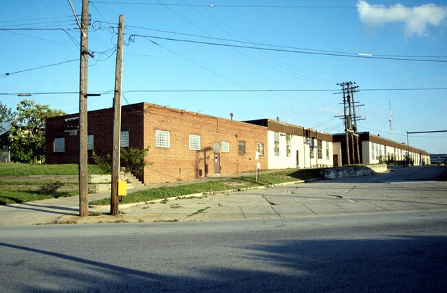
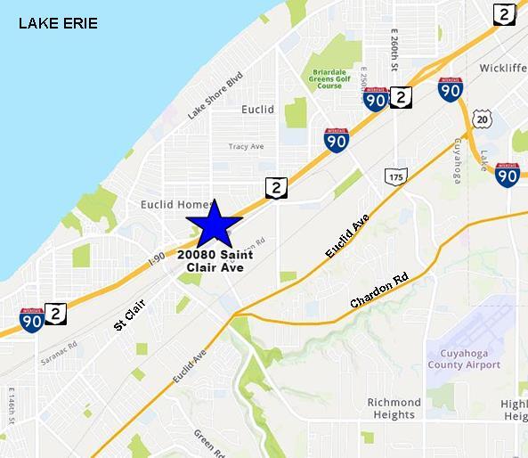
Property Detail
471 E 200Th St
Cleveland-Elyria, OH
14 EST 150FF
646-05-005
CUYAHOGA
Publicstorage
Ohio
U6
14
B and X Area of moderate flood hazard, usually the area between the limits of the 100-year and 500-year floods.
0.49 AC
2025
Euclid
2025
Cleveland
136104
NEARBY LISTINGS FOR SALE OR LEASE
DEMOGRAPHICS near 471 E 200Th St
1 mile
3 mile
5 mile
2025 Total Population
9,346
87,203
201,306
2030 Population
9,292
87,207
202,457
Pop Growth 2025-2030
(0.58%)
0.00%
+ 0.57%
Average Age
42
42
42
2025 Total Households
4,193
40,834
91,316
HH Growth 2025-2030
(0.83%)
(0.04%)
+ 0.57%
Median Household Inc
$44,673
$44,609
$50,709
Avg Household Size
2.10
2.10
2.10
2025 Avg HH Vehicles
1.00
1.00
1.00
Median Home Value
$99,900
$128,870
$150,021
Median Year Built
1950
1955
1954
Nearby Places
Map Layers
Map Styles
 Street
 Aerial
Transit
 Traffic
 Biking
Places
Listings with unknown addresses are not visible on the map
- Restaurants
- Banks
- Shops
- Fitness
- Groceries
PUBLIC TRANSPORTATION
AIRPORT
Cleveland-Hopkins International
Drive
Walk
Distance
Cleveland-Hopkins International
35 min
23.8 mi
Freight Ports
Port of Toledo
Drive
Walk
Distance
Port of Toledo
149 min
124.2 mi
SALE & LEASE HISTORY
LISTING DATE
SALE/LEASE

Sep 02, 2020
For Sale
Nearby Properties
Address
Land Use
TOTAL SIZE
Lot Size
Zoning
Address
Land Use
TOTAL SIZE
Lot Size
Zoning
63.59 AC
1F
Address
Land Use
TOTAL SIZE
Lot Size
Zoning
71.14 AC
U4
Address
Land Use
TOTAL SIZE
Lot Size
Zoning
44,577 SF
39.90 AC
SI
Address
Land Use
TOTAL SIZE
Lot Size
Zoning
386,776 SF
14.70 AC
CI
Address
Land Use
TOTAL SIZE
Lot Size
Zoning
112,657 SF
19.88 AC
U3
Address
Land Use
TOTAL SIZE
Lot Size
Zoning
149,685 SF
27.66 AC
R-1
Address
Land Use
TOTAL SIZE
Lot Size
Zoning
19,776 SF
13.41 AC
CI
Address
Land Use
TOTAL SIZE
Lot Size
Zoning
166,392 SF
36.46 AC
RMF-2
Address
Land Use
TOTAL SIZE
Lot Size
Zoning
450,285 SF
6.02 AC
LR
Address
Land Use
TOTAL SIZE
Lot Size
Zoning
190,580 SF
7.90 AC
P.F.
Address
Land Use
TOTAL SIZE
Lot Size
Zoning
2.53 AC
U6
Address
Land Use
TOTAL SIZE
Lot Size
Zoning
270,472 SF
5.92 AC
GR
Address
Land Use
TOTAL SIZE
Lot Size
Zoning
39.06 AC
U6
Address
Land Use
TOTAL SIZE
Lot Size
Zoning
275,040 SF
9.07 AC
U3
Address
Land Use
TOTAL SIZE
Lot Size
Zoning
10,200 SF
23.91 AC
Address
Land Use
TOTAL SIZE
Lot Size
Zoning
400,985 SF
34.80 AC
CI
Address
Land Use
TOTAL SIZE
Lot Size
Zoning
34.14 AC
U6
Address
Land Use
TOTAL SIZE
Lot Size
Zoning
47,055 SF
154.97 AC
I-1
Address
Land Use
TOTAL SIZE
Lot Size
Zoning
27,466 SF
13.39 AC
U6
Address
Land Use
TOTAL SIZE
Lot Size
Zoning
92,659 SF
4.25 AC
M
Address
Land Use
TOTAL SIZE
Lot Size
Zoning
175,620 SF
8.65 AC
M
Address
Land Use
TOTAL SIZE
Lot Size
Zoning
208,610 SF
7.54 AC
M
Address
Land Use
TOTAL SIZE
Lot Size
Zoning
61,352 SF
10.79 AC
M-I
Address
Land Use
TOTAL SIZE
Lot Size
Zoning
70,574 SF
6.35 AC
CI
Address
Land Use
TOTAL SIZE
Lot Size
Zoning
70,643 SF
8.26 AC
CI
Address
Land Use
TOTAL SIZE
Lot Size
Zoning
358,547 SF
8.22 AC
U3EL
Address
Land Use
TOTAL SIZE
Lot Size
Zoning
127,630 SF
3.19 AC
MF-1
Address
Land Use
TOTAL SIZE
Lot Size
Zoning
339,686 SF
5.65 AC
2F
Address
Land Use
TOTAL SIZE
Lot Size
Zoning
70,953 SF
8.66 AC
CI
Address
Land Use
TOTAL SIZE
Lot Size
Zoning
251,689 SF
2.13 AC
LR
The World's #1 Commercial Real Estate Marketplace
Connect with us
© 2026 CoStar Group
The information above has been obtained from sources believed reliable. While we do not doubt its accuracy we have not verified it and make no guarantee, warranty or representation about it. It is your responsibility to independently confirm its accuracy and completeness. Any projections, opinions, assumptions, or estimates used are for example only and do not represent the current or future performance of the property. The value of this transaction to you depends on tax and other factors which should be evaluated by your tax, financial, and legal advisors. You and your advisors should conduct a careful, independent investigation of the property to determine to your satisfaction the suitability of the property for your needs.