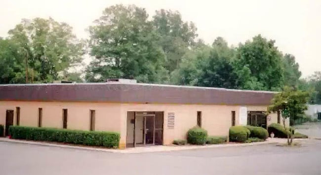
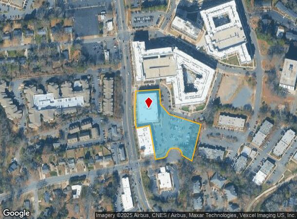
Property Record
4715 Park Rd, Charlotte, NC 28209
NEARBY LISTINGS FOR SALE OR LEASE
Property Detail
4715 Park Rd
Charlotte-Concord-Gastonia, NC-SC
Plat Of Morningstar Properties Llc
175-143-03
L1 M44-606
Publicstorage
Mecklenburg
X
North Carolina
3710454200K
1
2024
2.51 AC
2025
Park Road
003111
Charlotte
86,840 SF
DEMOGRAPHICS near 4715 Park Rd
1 Mile
3 Mile
5 Mile
2024 Total Population
13,644
106,707
267,469
2029 Population
14,556
113,105
284,219
Pop Growth 2024-2029
+ 6.68%
+ 6.00%
+ 6.26%
Average Age
38
38
37
2024 Total Households
7,108
48,276
124,746
HH Growth 2024-2029
+ 6.95%
+ 6.06%
+ 6.44%
Median Household Inc
$94,260
$95,871
$85,154
Avg Household Size
1.90
2.10
2.10
2024 Avg HH Vehicles
2.00
2.00
2.00
Median Home Value
$495,408
$596,826
$484,093
Median Year Built
1982
1984
1989
Nearby Places
Map Layers
Map Styles
 Street
 Aerial
- Restaurants
- Banks
- Shops
- Fitness
- Groceries
PUBLIC TRANSPORTATION
COMMUTER RAIL
DRIVE
WALK
Distance
13 min
6.3 mi
AIRPORT
Charlotte/Douglas International
DRIVE
WALK
Distance
Charlotte/Douglas International
16 min
8.1 mi
Concord-Padgett Regional
DRIVE
WALK
Distance
Concord-Padgett Regional
34 min
21.6 mi
Nearby Properties
Address
Land Use
TOTAL SIZE
Lot Size
Zoning
Address
Land Use
TOTAL SIZE
Lot Size
Zoning
3,286,640 SF
55.70 AC
O6CD
Address
Land Use
TOTAL SIZE
Lot Size
Zoning
875,672 SF
41.66 AC
CC
Address
Land Use
TOTAL SIZE
Lot Size
Zoning
965,867 SF
5.81 AC
O1
Address
Land Use
TOTAL SIZE
Lot Size
Zoning
709,410 SF
22.24 AC
INSTCD
Address
Land Use
TOTAL SIZE
Lot Size
Zoning
743,550 SF
4.69 AC
I2
Address
Land Use
TOTAL SIZE
Lot Size
Zoning
505,747 SF
3.87 AC
Address
Land Use
TOTAL SIZE
Lot Size
Zoning
639,406 SF
2.76 AC
TOD-UC
Address
Land Use
TOTAL SIZE
Lot Size
Zoning
692,098 SF
7.83 AC
MUDDO
Address
Land Use
TOTAL SIZE
Lot Size
Zoning
711,907 SF
4.84 AC
Address
Land Use
TOTAL SIZE
Lot Size
Zoning
573,667 SF
5.81 AC
MUDDO
Address
Land Use
TOTAL SIZE
Lot Size
Zoning
831,732 SF
24.50 AC
R3
Address
Land Use
TOTAL SIZE
Lot Size
Zoning
357,769 SF
4.93 AC
Address
Land Use
TOTAL SIZE
Lot Size
Zoning
546,111 SF
4.85 AC
MUDDCD
Address
Land Use
TOTAL SIZE
Lot Size
Zoning
534,085 SF
0.85 AC
MUDDO
Address
Land Use
TOTAL SIZE
Lot Size
Zoning
653,339 SF
6.20 AC
Address
Land Use
TOTAL SIZE
Lot Size
Zoning
409,916 SF
2.90 AC
I2
Address
Land Use
TOTAL SIZE
Lot Size
Zoning
572,979 SF
5.60 AC
O3
Address
Land Use
TOTAL SIZE
Lot Size
Zoning
528,907 SF
18.13 AC
CC
Address
Land Use
TOTAL SIZE
Lot Size
Zoning
460,937 SF
2.67 AC
O1
Address
Land Use
TOTAL SIZE
Lot Size
Zoning
544,973 SF
3.42 AC
Address
Land Use
TOTAL SIZE
Lot Size
Zoning
434,803 SF
4.58 AC
I2
Address
Land Use
TOTAL SIZE
Lot Size
Zoning
419,445 SF
2 AC
TOD-UC
Address
Land Use
TOTAL SIZE
Lot Size
Zoning
501,350 SF
6.82 AC
Address
Land Use
TOTAL SIZE
Lot Size
Zoning
554,176 SF
3.88 AC
I-2
Address
Land Use
TOTAL SIZE
Lot Size
Zoning
500,799 SF
4.48 AC
I2
Address
Land Use
TOTAL SIZE
Lot Size
Zoning
447,816 SF
3.42 AC
I2
Address
Land Use
TOTAL SIZE
Lot Size
Zoning
473,582 SF
3.41 AC
TOD-TR
Address
Land Use
TOTAL SIZE
Lot Size
Zoning
493,745 SF
4.25 AC
I2
Address
Land Use
TOTAL SIZE
Lot Size
Zoning
356,838 SF
27.63 AC
B1
Address
Land Use
TOTAL SIZE
Lot Size
Zoning
427,305 SF
3.21 AC
O2CD
The World's #1 Commercial Real Estate Marketplace
Connect with us
© 2025 CoStar Group
The information above has been obtained from sources believed reliable. While we do not doubt its accuracy we have not verified it and make no guarantee, warranty or representation about it. It is your responsibility to independently confirm its accuracy and completeness. Any projections, opinions, assumptions, or estimates used are for example only and do not represent the current or future performance of the property. The value of this transaction to you depends on tax and other factors which should be evaluated by your tax, financial, and legal advisors. You and your advisors should conduct a careful, independent investigation of the property to determine to your satisfaction the suitability of the property for your needs.