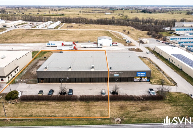
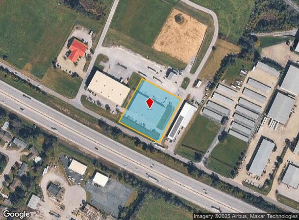
Property Record
4733 Rockwell Rd, Winchester, KY 40391
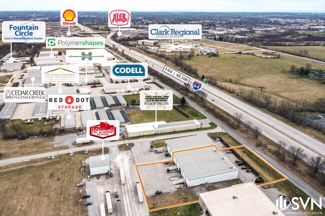
NEARBY LISTINGS FOR SALE OR LEASE
Property Detail
4733 Rockwell Rd
032-0000-00906
PARCEL A-4 PLAT 2300
Commercialnec
Clark
X
Kentucky
21049C0038D
2.01 AC
2024
Clark County
2024
Lexington/Fayette
020600
Lexington-Fayette, KY
DEMOGRAPHICS near 4733 Rockwell Rd
1 Mile
3 Mile
5 Mile
2024 Total Population
322
17,481
29,675
2029 Population
326
17,625
29,940
Pop Growth 2024-2029
+ 1.24%
+ 0.82%
+ 0.89%
Average Age
39
41
40
2024 Total Households
127
7,263
12,107
HH Growth 2024-2029
+ 0.79%
+ 0.84%
+ 0.90%
Median Household Inc
$81,481
$54,863
$57,482
Avg Household Size
2.50
2.30
2.40
2024 Avg HH Vehicles
2.00
2.00
2.00
Median Home Value
$189,999
$170,393
$171,813
Median Year Built
2002
1980
1979
Nearby Places
Map Layers
Map Styles
 Street
 Aerial
- Restaurants
- Banks
- Shops
- Fitness
- Groceries
PUBLIC TRANSPORTATION
AIRPORT
Blue Grass
DRIVE
WALK
Distance
Blue Grass
33 min
28.2 mi
Freight Ports
Virginia Port Authority - Richmond
DRIVE
WALK
Distance
Virginia Port Authority - Richmond
1 min
373.5 mi
SALE & LEASE HISTORY
LISTING DATE
SALE/LEASE

Sep 25, 2016
For Lease
Sep 15, 2023
For Lease
Mar 28, 2022
For Lease
Mar 26, 2025
For Lease
Mar 24, 2017
For Lease
Jan 18, 2018
For Sale
Nearby Properties
Address
Land Use
TOTAL SIZE
Lot Size
Zoning
Address
Land Use
TOTAL SIZE
Lot Size
Zoning
45,000 SF
30.26 AC
AGRICULTUR
Address
Land Use
TOTAL SIZE
Lot Size
Zoning
423,158 SF
36.32 AC
LIGHT INDU
Address
Land Use
TOTAL SIZE
Lot Size
Zoning
127.39 AC
Address
Land Use
TOTAL SIZE
Lot Size
Zoning
Address
Land Use
TOTAL SIZE
Lot Size
Zoning
Address
Land Use
TOTAL SIZE
Lot Size
Zoning
Address
Land Use
TOTAL SIZE
Lot Size
Zoning
Address
Land Use
TOTAL SIZE
Lot Size
Zoning
Address
Land Use
TOTAL SIZE
Lot Size
Zoning
179,856 SF
20.42 AC
PLANNED DE
Address
Land Use
TOTAL SIZE
Lot Size
Zoning
60,726 SF
14.59 AC
Address
Land Use
TOTAL SIZE
Lot Size
Zoning
Address
Land Use
TOTAL SIZE
Lot Size
Zoning
698,666 SF
44.85 AC
LIGHT INDU
Address
Land Use
TOTAL SIZE
Lot Size
Zoning
6.65 AC
I1
Address
Land Use
TOTAL SIZE
Lot Size
Zoning
6.50 AC
PD
Address
Land Use
TOTAL SIZE
Lot Size
Zoning
0.98 AC
DOWNTOWN B
Address
Land Use
TOTAL SIZE
Lot Size
Zoning
17.86 AC
I1
Address
Land Use
TOTAL SIZE
Lot Size
Zoning
121,809 SF
19.44 AC
LIGHT INDU
Address
Land Use
TOTAL SIZE
Lot Size
Zoning
76,440 SF
15.67 AC
PLANNED DE
Address
Land Use
TOTAL SIZE
Lot Size
Zoning
64,000 SF
8.45 AC
HIGHWAY BU
Address
Land Use
TOTAL SIZE
Lot Size
Zoning
3.15 AC
Address
Land Use
TOTAL SIZE
Lot Size
Zoning
60,060 SF
6.04 AC
HIGHWAY BU
Address
Land Use
TOTAL SIZE
Lot Size
Zoning
15.06 AC
I1
Address
Land Use
TOTAL SIZE
Lot Size
Zoning
3.59 AC
I1
Address
Land Use
TOTAL SIZE
Lot Size
Zoning
69,834 SF
8.82 AC
PLANNED DE
Address
Land Use
TOTAL SIZE
Lot Size
Zoning
1.07 AC
PD
Address
Land Use
TOTAL SIZE
Lot Size
Zoning
Address
Land Use
TOTAL SIZE
Lot Size
Zoning
1.21 AC
B3
Address
Land Use
TOTAL SIZE
Lot Size
Zoning
45,220 SF
5.03 AC
HIGHWAY BU
Address
Land Use
TOTAL SIZE
Lot Size
Zoning
112,148 SF
13.81 AC
LIGHT INDU
Address
Land Use
TOTAL SIZE
Lot Size
Zoning
1.90 AC
B3
The World's #1 Commercial Real Estate Marketplace
Connect with us
© 2025 CoStar Group
The information above has been obtained from sources believed reliable. While we do not doubt its accuracy we have not verified it and make no guarantee, warranty or representation about it. It is your responsibility to independently confirm its accuracy and completeness. Any projections, opinions, assumptions, or estimates used are for example only and do not represent the current or future performance of the property. The value of this transaction to you depends on tax and other factors which should be evaluated by your tax, financial, and legal advisors. You and your advisors should conduct a careful, independent investigation of the property to determine to your satisfaction the suitability of the property for your needs.