Property Record
476 S Franklin St, Holbrook, MA 02343
NEARBY LISTINGS FOR SALE OR LEASE
Property Detail
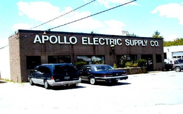
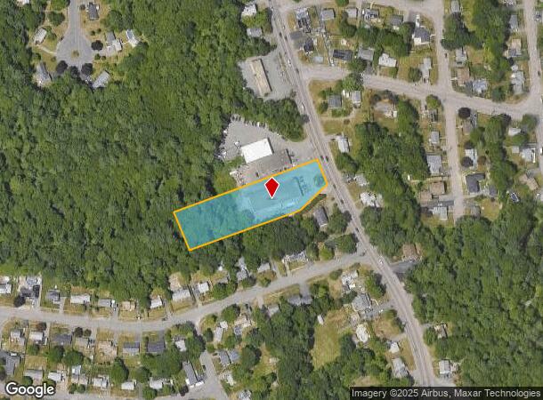
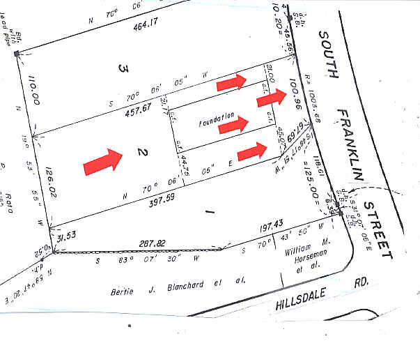
476 S Franklin St
HOLB-000034-000000-000046-000003
80 Clapp St
Storebuilding
Norfolk
AE
Massachusetts
25021C0219F
46-3-0
2025
1.31 AC
2025
Route 24
421100
Boston
13,020 SF
Boston-Cambridge-Newton, MA-NH
DEMOGRAPHICS near 476 S Franklin St
1 Mile
3 Mile
5 Mile
2024 Total Population
5,937
61,019
208,123
2029 Population
5,878
60,647
206,466
Pop Growth 2024-2029
(0.99%)
(0.61%)
(0.80%)
Average Age
42
41
41
2024 Total Households
2,255
21,860
76,200
HH Growth 2024-2029
(1.02%)
(0.67%)
(0.84%)
Median Household Inc
$86,346
$97,185
$88,879
Avg Household Size
2.60
2.70
2.60
2024 Avg HH Vehicles
2.00
2.00
2.00
Median Home Value
$369,624
$408,772
$432,363
Median Year Built
1956
1959
1962
Nearby Places
Map Layers
Map Styles
 Street
 Aerial
- Restaurants
- Banks
- Shops
- Fitness
- Groceries
PUBLIC TRANSPORTATION
COMMUTER RAIL
Holbrook/Randolph (Middleborough/Lakeville Line - Massachusetts Bay Transportation Authority Commuter Rail (Purple Line))
DRIVE
WALK
Distance
Holbrook/Randolph (Middleborough/Lakeville Line - Massachusetts Bay Transportation Authority Commuter Rail (Purple Line))
4 min
2.2 mi
Montello (Middleborough/Lakeville Line - Massachusetts Bay Transportation Authority Commuter Rail (Purple Line))
DRIVE
WALK
Distance
Montello (Middleborough/Lakeville Line - Massachusetts Bay Transportation Authority Commuter Rail (Purple Line))
5 min
2.8 mi
AIRPORT
General Edward Lawrence Logan International
DRIVE
WALK
Distance
General Edward Lawrence Logan International
33 min
19.8 mi
Freight Ports
Port of Boston
DRIVE
WALK
Distance
Port of Boston
31 min
17.6 mi
Nearby Properties
Address
Land Use
TOTAL SIZE
Lot Size
Zoning
Address
Land Use
TOTAL SIZE
Lot Size
Zoning
40,396 SF
5.56 AC
100
Address
Land Use
TOTAL SIZE
Lot Size
Zoning
235,150 SF
36.67 AC
R1
Address
Land Use
TOTAL SIZE
Lot Size
Zoning
13.08 AC
HB
Address
Land Use
TOTAL SIZE
Lot Size
Zoning
168,801 SF
2.75 AC
100
Address
Land Use
TOTAL SIZE
Lot Size
Zoning
170,035 SF
1.64 AC
100
Address
Land Use
TOTAL SIZE
Lot Size
Zoning
10.10 AC
CSBD
Address
Land Use
TOTAL SIZE
Lot Size
Zoning
379,908 SF
15.14 AC
Address
Land Use
TOTAL SIZE
Lot Size
Zoning
76,223 SF
19.83 AC
B
Address
Land Use
TOTAL SIZE
Lot Size
Zoning
299,062 SF
22.73 AC
R2
Address
Land Use
TOTAL SIZE
Lot Size
Zoning
34.28 AC
85
Address
Land Use
TOTAL SIZE
Lot Size
Zoning
34.45 AC
HB
Address
Land Use
TOTAL SIZE
Lot Size
Zoning
1,204 SF
15.08 AC
R1C
Address
Land Use
TOTAL SIZE
Lot Size
Zoning
121,424 SF
11.11 AC
HB
Address
Land Use
TOTAL SIZE
Lot Size
Zoning
10.83 AC
Address
Land Use
TOTAL SIZE
Lot Size
Zoning
2,077 SF
5.68 AC
R2
Address
Land Use
TOTAL SIZE
Lot Size
Zoning
48,997 SF
5.68 AC
R3
Address
Land Use
TOTAL SIZE
Lot Size
Zoning
14.52 AC
Address
Land Use
TOTAL SIZE
Lot Size
Zoning
190,000 SF
11.42 AC
Address
Land Use
TOTAL SIZE
Lot Size
Zoning
1.95 AC
A
Address
Land Use
TOTAL SIZE
Lot Size
Zoning
3.82 AC
A
Address
Land Use
TOTAL SIZE
Lot Size
Zoning
1,452 SF
28.90 AC
R1C
Address
Land Use
TOTAL SIZE
Lot Size
Zoning
119,130 SF
14.29 AC
HB
Address
Land Use
TOTAL SIZE
Lot Size
Zoning
89,764 SF
6.77 AC
Address
Land Use
TOTAL SIZE
Lot Size
Zoning
137,765 SF
12.40 AC
Address
Land Use
TOTAL SIZE
Lot Size
Zoning
12.17 AC
R4
Address
Land Use
TOTAL SIZE
Lot Size
Zoning
100,000 SF
8.60 AC
Address
Land Use
TOTAL SIZE
Lot Size
Zoning
150,995 SF
10.13 AC
Address
Land Use
TOTAL SIZE
Lot Size
Zoning
1,384 SF
14.23 AC
R1C
Address
Land Use
TOTAL SIZE
Lot Size
Zoning
144,252 SF
8.70 AC
Address
Land Use
TOTAL SIZE
Lot Size
Zoning
69,149 SF
2 AC
HA
The World's #1 Commercial Real Estate Marketplace
Connect with us
© 2025 CoStar Group
The information above has been obtained from sources believed reliable. While we do not doubt its accuracy we have not verified it and make no guarantee, warranty or representation about it. It is your responsibility to independently confirm its accuracy and completeness. Any projections, opinions, assumptions, or estimates used are for example only and do not represent the current or future performance of the property. The value of this transaction to you depends on tax and other factors which should be evaluated by your tax, financial, and legal advisors. You and your advisors should conduct a careful, independent investigation of the property to determine to your satisfaction the suitability of the property for your needs.