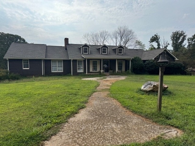
Property Record
480 Bishop Rd, Ball Ground, GA 30107
This Property Is For Sale
NEARBY LISTINGS FOR SALE OR LEASE
Property Detail
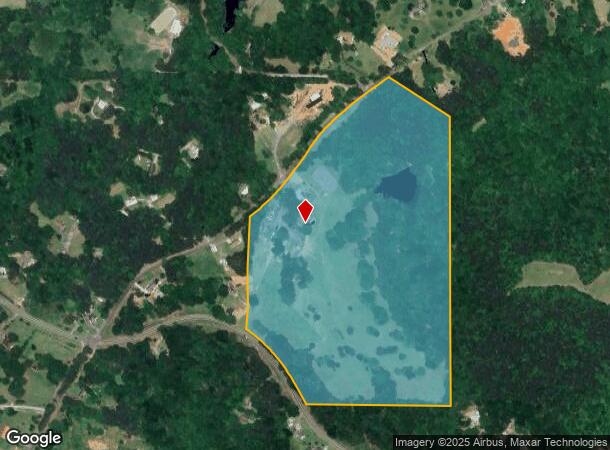
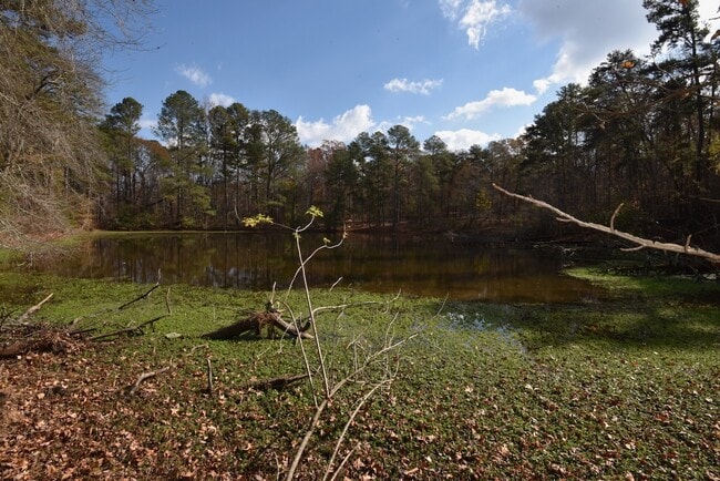
480 Bishop Rd
Atlanta-Sandy Springs-Roswell, GA
Not Shown
014N26-00000-009-000-0000
Cherokee
Sfr
Georgia
X
52.68 AC
13057C0162E
Cherokee County
2,453 SF
Atlanta
DEMOGRAPHICS near 480 Bishop Rd
1 Mile
3 Mile
5 Mile
2024 Total Population
953
9,530
31,797
2029 Population
1,033
10,453
34,849
Pop Growth 2024-2029
+ 8.39%
+ 9.69%
+ 9.60%
Average Age
41
41
41
2024 Total Households
338
3,415
11,772
HH Growth 2024-2029
+ 8.28%
+ 9.69%
+ 9.63%
Median Household Inc
$98,836
$101,786
$87,422
Avg Household Size
2.80
2.80
2.70
2024 Avg HH Vehicles
2.00
2.00
2.00
Median Home Value
$560,219
$546,971
$488,584
Median Year Built
2005
2007
2002
Nearby Places
- Restaurants
- Banks
- Shops
- Fitness
- Groceries
Nearby Properties
Address
Land Use
TOTAL SIZE
Lot Size
Zoning
Address
Land Use
TOTAL SIZE
Lot Size
Zoning
80,795 SF
34.86 AC
PD-MIXED U
Address
Land Use
TOTAL SIZE
Lot Size
Zoning
197.68 AC
PD-MU
Address
Land Use
TOTAL SIZE
Lot Size
Zoning
548,520 SF
70.10 AC
LI
Address
Land Use
TOTAL SIZE
Lot Size
Zoning
687,913 SF
24.31 AC
LI
Address
Land Use
TOTAL SIZE
Lot Size
Zoning
78,236 SF
23.64 AC
PD
Address
Land Use
TOTAL SIZE
Lot Size
Zoning
66,710 SF
15.14 AC
PD-MU
Address
Land Use
TOTAL SIZE
Lot Size
Zoning
296,607 SF
46.53 AC
LI
Address
Land Use
TOTAL SIZE
Lot Size
Zoning
84,304 SF
18.65 AC
HI
Address
Land Use
TOTAL SIZE
Lot Size
Zoning
9,142 SF
89.03 AC
LI
Address
Land Use
TOTAL SIZE
Lot Size
Zoning
30,816 SF
63.71 AC
LI
Address
Land Use
TOTAL SIZE
Lot Size
Zoning
58.19 AC
PD-MIXED U
Address
Land Use
TOTAL SIZE
Lot Size
Zoning
63,061 SF
11.22 AC
GC
Address
Land Use
TOTAL SIZE
Lot Size
Zoning
62,108 SF
25 AC
OI
Address
Land Use
TOTAL SIZE
Lot Size
Zoning
108,892 SF
16.53 AC
LI
Address
Land Use
TOTAL SIZE
Lot Size
Zoning
82,621 SF
9.63 AC
PD-MU
Address
Land Use
TOTAL SIZE
Lot Size
Zoning
83.99 AC
LI
Address
Land Use
TOTAL SIZE
Lot Size
Zoning
123.28 AC
LI
Address
Land Use
TOTAL SIZE
Lot Size
Zoning
73,584 SF
10.93 AC
LI
Address
Land Use
TOTAL SIZE
Lot Size
Zoning
49,389 SF
10.21 AC
GC
Address
Land Use
TOTAL SIZE
Lot Size
Zoning
76,696 SF
5.75 AC
LI
Address
Land Use
TOTAL SIZE
Lot Size
Zoning
21,896 SF
1.63 AC
LI
Address
Land Use
TOTAL SIZE
Lot Size
Zoning
15,748 SF
35.85 AC
HI
Address
Land Use
TOTAL SIZE
Lot Size
Zoning
56,298 SF
5.48 AC
PD-MU
Address
Land Use
TOTAL SIZE
Lot Size
Zoning
57,587 SF
5.89 AC
PD-MU
Address
Land Use
TOTAL SIZE
Lot Size
Zoning
49,300 SF
4.18 AC
PD-MU
Address
Land Use
TOTAL SIZE
Lot Size
Zoning
19.45 AC
LI
Address
Land Use
TOTAL SIZE
Lot Size
Zoning
21,992 SF
3.93 AC
GC
Address
Land Use
TOTAL SIZE
Lot Size
Zoning
45.34 AC
PD-MU
Address
Land Use
TOTAL SIZE
Lot Size
Zoning
51.33 AC
LI
Address
Land Use
TOTAL SIZE
Lot Size
Zoning
48,750 SF
4.33 AC
PD-MU
The World's #1 Commercial Real Estate Marketplace
Connect with us
© 2025 CoStar Group
The information above has been obtained from sources believed reliable. While we do not doubt its accuracy we have not verified it and make no guarantee, warranty or representation about it. It is your responsibility to independently confirm its accuracy and completeness. Any projections, opinions, assumptions, or estimates used are for example only and do not represent the current or future performance of the property. The value of this transaction to you depends on tax and other factors which should be evaluated by your tax, financial, and legal advisors. You and your advisors should conduct a careful, independent investigation of the property to determine to your satisfaction the suitability of the property for your needs.