Property Record
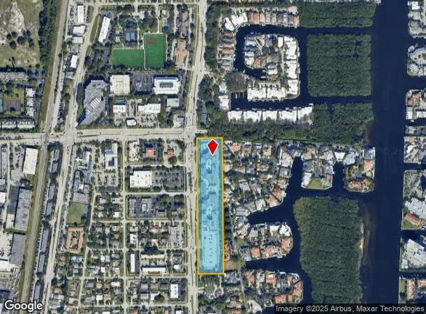
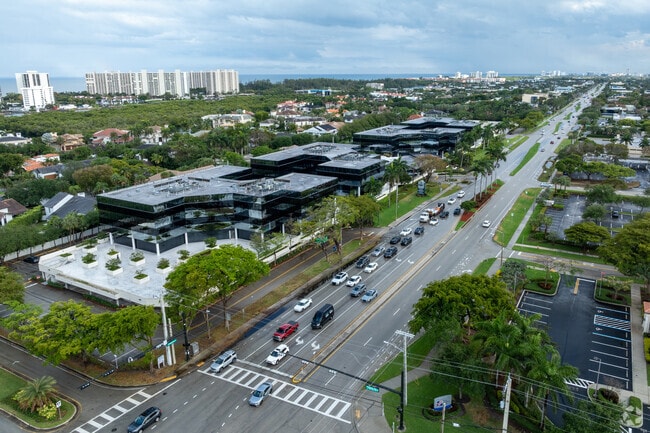
4800 N Federal Hwy, Boca Raton, FL 33431


NEARBY LISTINGS FOR SALE OR LEASE
Property Detail
4800 N Federal Hwy
06-43-47-08-41-001-1001
Sanctuary Centre Condominium
Officecondo
SANCTUARY CENTRE CONDOMINIUM UNITS A1001 THRU A1039~ UNIT A1043 IN OR28421P935~ UNITS A1044 THRU A1050 & A1083 THRU A1088
X
Palm Beach
12099C0989G
Florida
2024
1 AC
2025
Boca Raton East
007302
South Florida
6,912 SF
West Palm Beach-Boca Raton-Delray Beach, FL
DEMOGRAPHICS near 4800 N Federal Hwy
1 Mile
3 Mile
5 Mile
2024 Total Population
12,968
69,106
180,433
2029 Population
13,832
73,645
190,702
Pop Growth 2024-2029
+ 6.66%
+ 6.57%
+ 5.69%
Average Age
51
47
47
2024 Total Households
6,215
31,236
81,252
HH Growth 2024-2029
+ 6.60%
+ 7.07%
+ 5.91%
Median Household Inc
$86,731
$88,458
$87,120
Avg Household Size
2.00
2.00
2.00
2024 Avg HH Vehicles
2.00
2.00
2.00
Median Home Value
$584,741
$518,996
$525,607
Median Year Built
1980
1984
1984
Nearby Places
Map Layers
Map Styles
 Street
 Aerial
- Restaurants
- Banks
- Shops
- Fitness
- Groceries
PUBLIC TRANSPORTATION
COMMUTER RAIL
Boca Raton (Tri-County Commuter - South Florida Regional Transportation Authority (Tri-Rail))
DRIVE
WALK
Distance
Boca Raton (Tri-County Commuter - South Florida Regional Transportation Authority (Tri-Rail))
6 min
2.0 mi
DRIVE
WALK
Distance
7 min
3.4 mi
AIRPORT
Palm Beach International
DRIVE
WALK
Distance
Palm Beach International
32 min
23.5 mi
Fort Lauderdale/Hollywood International
DRIVE
WALK
Distance
Fort Lauderdale/Hollywood International
37 min
27.5 mi
Freight Ports
Port Everglades
DRIVE
WALK
Distance
Port Everglades
36 min
26.2 mi
SALE & LEASE HISTORY
LISTING DATE
SALE/LEASE

Mar 23, 2023
For Lease
Mar 23, 2023
For Sale
Mar 13, 2023
For Sale
Jun 18, 2025
For Lease
Jun 05, 2025
For Sale
Jun 04, 2025
For Sale
Jul 10, 2023
For Lease
Jan 29, 2025
For Sale
Dec 21, 2023
For Sale
Apr 23, 2025
For Lease
Nearby Properties
Address
Land Use
TOTAL SIZE
Lot Size
Zoning
Address
Land Use
TOTAL SIZE
Lot Size
Zoning
2,250,267 SF
260 AC
PL
Address
Land Use
TOTAL SIZE
Lot Size
Zoning
2,361,481 SF
120.60 AC
PL
Address
Land Use
TOTAL SIZE
Lot Size
Zoning
779,243 SF
205.02 AC
PL
Address
Land Use
TOTAL SIZE
Lot Size
Zoning
491,320 SF
11.51 AC
LIRP PMD
Address
Land Use
TOTAL SIZE
Lot Size
Zoning
437,556 SF
11.50 AC
LIRP PMD
Address
Land Use
TOTAL SIZE
Lot Size
Zoning
467,728 SF
18.73 AC
LIRP PMD
Address
Land Use
TOTAL SIZE
Lot Size
Zoning
1,949,101 SF
123.29 AC
LIRP
Address
Land Use
TOTAL SIZE
Lot Size
Zoning
373,856 SF
4.12 AC
LIRP PMD
Address
Land Use
TOTAL SIZE
Lot Size
Zoning
435,852 SF
17.38 AC
VC
Address
Land Use
TOTAL SIZE
Lot Size
Zoning
360,718 SF
3.67 AC
LIRP PMD
Address
Land Use
TOTAL SIZE
Lot Size
Zoning
760,812 SF
23.60 AC
MC
Address
Land Use
TOTAL SIZE
Lot Size
Zoning
542,392 SF
27.95 AC
R-1-D
Address
Land Use
TOTAL SIZE
Lot Size
Zoning
1,090,620 SF
28.89 AC
LIRP
Address
Land Use
TOTAL SIZE
Lot Size
Zoning
293,358 SF
9.05 AC
LIRP PMD
Address
Land Use
TOTAL SIZE
Lot Size
Zoning
251,039 SF
11 AC
SAD
Address
Land Use
TOTAL SIZE
Lot Size
Zoning
228,097 SF
10.63 AC
M-2
Address
Land Use
TOTAL SIZE
Lot Size
Zoning
230,420 SF
2.64 AC
DDRI
Address
Land Use
TOTAL SIZE
Lot Size
Zoning
380,823 SF
23.10 AC
LIRP PMD
Address
Land Use
TOTAL SIZE
Lot Size
Zoning
246,721 SF
16.64 AC
SAD
Address
Land Use
TOTAL SIZE
Lot Size
Zoning
194,972 SF
48.62 AC
PL
Address
Land Use
TOTAL SIZE
Lot Size
Zoning
21.75 AC
PL
Address
Land Use
TOTAL SIZE
Lot Size
Zoning
497,879 SF
3.94 AC
DDRI
Address
Land Use
TOTAL SIZE
Lot Size
Zoning
214,166 SF
9.10 AC
LIRP PMD
Address
Land Use
TOTAL SIZE
Lot Size
Zoning
10,166 SF
27.03 AC
REC
Address
Land Use
TOTAL SIZE
Lot Size
Zoning
294,419 SF
18.29 AC
M-3
Address
Land Use
TOTAL SIZE
Lot Size
Zoning
173,803 SF
15.94 AC
R-B-1
Address
Land Use
TOTAL SIZE
Lot Size
Zoning
362,445 SF
6.81 AC
POI
Address
Land Use
TOTAL SIZE
Lot Size
Zoning
12,074 SF
15.38 AC
PL
Address
Land Use
TOTAL SIZE
Lot Size
Zoning
212,574 SF
4.67 AC
R-4
Address
Land Use
TOTAL SIZE
Lot Size
Zoning
151,286 SF
55.71 AC
The World's #1 Commercial Real Estate Marketplace
Connect with us
© 2025 CoStar Group
The information above has been obtained from sources believed reliable. While we do not doubt its accuracy we have not verified it and make no guarantee, warranty or representation about it. It is your responsibility to independently confirm its accuracy and completeness. Any projections, opinions, assumptions, or estimates used are for example only and do not represent the current or future performance of the property. The value of this transaction to you depends on tax and other factors which should be evaluated by your tax, financial, and legal advisors. You and your advisors should conduct a careful, independent investigation of the property to determine to your satisfaction the suitability of the property for your needs.