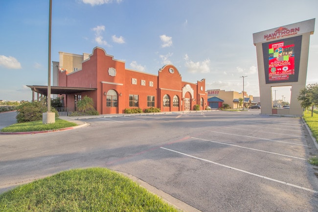
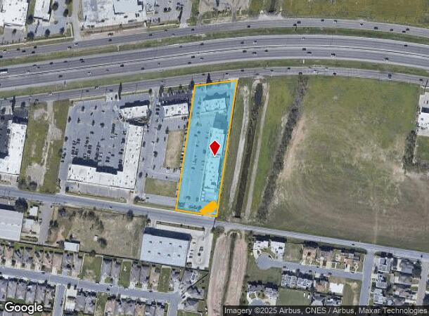
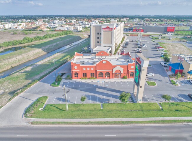
Property Record
4801 W Expressway 83, Mcallen, TX 78503
NEARBY LISTINGS FOR SALE OR LEASE
Property Detail
4801 W Expressway 83
McAllen/Edinburg/Pharr
Shary Gateway
McAllen-Edinburg-Mission, TX
SHARY GATEWAY LOT 4
S2775-00-000-0004-00
Hidalgo
Commercialnec
Texas
2024
4
2025
3.09 AC
020511
Greater McAllen
103,741 SF
DEMOGRAPHICS near 4801 W Expressway 83
1 Mile
3 Mile
5 Mile
2024 Total Population
7,564
87,769
192,667
2029 Population
8,210
93,129
204,206
Pop Growth 2024-2029
+ 8.54%
+ 6.11%
+ 5.99%
Average Age
35
38
37
2024 Total Households
2,498
29,167
64,169
HH Growth 2024-2029
+ 8.25%
+ 6.13%
+ 5.98%
Median Household Inc
$44,616
$45,408
$48,184
Avg Household Size
3.00
2.90
2.90
2024 Avg HH Vehicles
2.00
2.00
2.00
Median Home Value
$191,817
$149,084
$146,123
Median Year Built
2004
1996
1994
Nearby Places
Map Layers
Map Styles
 Street
 Aerial
- Restaurants
- Banks
- Shops
- Fitness
- Groceries
PUBLIC TRANSPORTATION
AIRPORT
McAllen International
DRIVE
WALK
Distance
McAllen International
7 min
3.6 mi
Freight Ports
Port of Brownsville
DRIVE
WALK
Distance
Port of Brownsville
71 min
62.5 mi
SALE & LEASE HISTORY
LISTING DATE
SALE/LEASE

Jul 11, 2018
For Lease
Feb 28, 2019
For Lease
Nearby Properties
Address
Land Use
TOTAL SIZE
Lot Size
Zoning
Address
Land Use
TOTAL SIZE
Lot Size
Zoning
1,199,590 SF
47.93 AC
Address
Land Use
TOTAL SIZE
Lot Size
Zoning
291,859 SF
10.11 AC
CO
Address
Land Use
TOTAL SIZE
Lot Size
Zoning
165,620 SF
24.44 AC
Address
Land Use
TOTAL SIZE
Lot Size
Zoning
93,471 SF
12.66 AC
Address
Land Use
TOTAL SIZE
Lot Size
Zoning
18 SF
82.24 AC
Address
Land Use
TOTAL SIZE
Lot Size
Zoning
354,558 SF
26.79 AC
Address
Land Use
TOTAL SIZE
Lot Size
Zoning
232,217 SF
22.78 AC
CO
Address
Land Use
TOTAL SIZE
Lot Size
Zoning
263,388 SF
37.48 AC
Address
Land Use
TOTAL SIZE
Lot Size
Zoning
235,545 SF
40.51 AC
Address
Land Use
TOTAL SIZE
Lot Size
Zoning
191,978 SF
2.22 AC
Address
Land Use
TOTAL SIZE
Lot Size
Zoning
252,435 SF
9.09 AC
Address
Land Use
TOTAL SIZE
Lot Size
Zoning
208,941 SF
18.57 AC
Address
Land Use
TOTAL SIZE
Lot Size
Zoning
159,617 SF
5.38 AC
Address
Land Use
TOTAL SIZE
Lot Size
Zoning
105,440 SF
19.84 AC
Address
Land Use
TOTAL SIZE
Lot Size
Zoning
236,124 SF
14.03 AC
Address
Land Use
TOTAL SIZE
Lot Size
Zoning
287,691 SF
33.57 AC
Address
Land Use
TOTAL SIZE
Lot Size
Zoning
39,603 SF
3.95 AC
Address
Land Use
TOTAL SIZE
Lot Size
Zoning
348,254 SF
12.05 AC
IN
Address
Land Use
TOTAL SIZE
Lot Size
Zoning
3,000 SF
16 AC
Address
Land Use
TOTAL SIZE
Lot Size
Zoning
73,507 SF
23.84 AC
Address
Land Use
TOTAL SIZE
Lot Size
Zoning
156,516 SF
13.65 AC
Address
Land Use
TOTAL SIZE
Lot Size
Zoning
108,527 SF
1.49 AC
Address
Land Use
TOTAL SIZE
Lot Size
Zoning
177,334 SF
10.31 AC
Address
Land Use
TOTAL SIZE
Lot Size
Zoning
289,443 SF
12.91 AC
CO
Address
Land Use
TOTAL SIZE
Lot Size
Zoning
1 SF
7.79 AC
Address
Land Use
TOTAL SIZE
Lot Size
Zoning
269,767 SF
17.98 AC
Address
Land Use
TOTAL SIZE
Lot Size
Zoning
59,078 SF
12.65 AC
CO
Address
Land Use
TOTAL SIZE
Lot Size
Zoning
59,816 SF
2.42 AC
Address
Land Use
TOTAL SIZE
Lot Size
Zoning
288,657 SF
16.75 AC
IN
Address
Land Use
TOTAL SIZE
Lot Size
Zoning
69,184 SF
2.94 AC
The World's #1 Commercial Real Estate Marketplace
Connect with us
© 2026 CoStar Group
The information above has been obtained from sources believed reliable. While we do not doubt its accuracy we have not verified it and make no guarantee, warranty or representation about it. It is your responsibility to independently confirm its accuracy and completeness. Any projections, opinions, assumptions, or estimates used are for example only and do not represent the current or future performance of the property. The value of this transaction to you depends on tax and other factors which should be evaluated by your tax, financial, and legal advisors. You and your advisors should conduct a careful, independent investigation of the property to determine to your satisfaction the suitability of the property for your needs.