Property Record
481 Applegate Way, Ashland, OR 97520
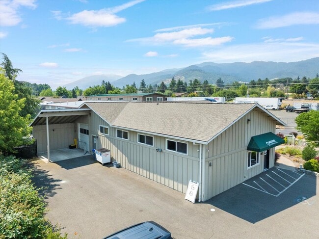

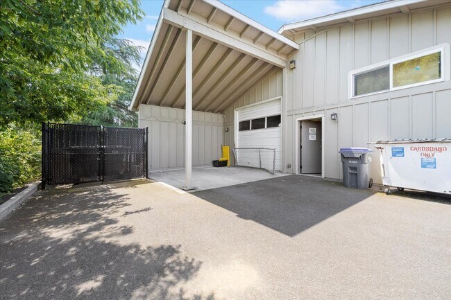

Property Detail
481 Applegate Way
10886318
Jackson
Commercialbuilding
Oregon
E-1
1
B and X Area of moderate flood hazard, usually the area between the limits of the 100-year and 500-year floods.
0.35 AC
2025
Medford/Grants Pass
2026
Other Market Areas
002400
Medford, OR
3,472 SF
NEARBY LISTINGS FOR SALE OR LEASE
DEMOGRAPHICS near 481 Applegate Way
1 mile
3 mile
5 mile
2025 Total Population
1,885
19,689
27,004
2030 Population
1,867
20,057
27,384
Pop Growth 2025-2030
(0.95%)
+ 1.87%
+ 1.41%
Average Age
46
43
45
2025 Total Households
868
8,915
12,317
HH Growth 2025-2030
(0.92%)
+ 1.93%
+ 1.43%
Median Household Inc
$72,895
$63,577
$68,303
Avg Household Size
2.10
2.00
2.00
2025 Avg HH Vehicles
2.00
2.00
2.00
Median Home Value
$552,760
$636,913
$657,753
Median Year Built
1994
1987
1985
Nearby Places
Map Layers
Map Styles
 Street
 Aerial
Transit
 Traffic
 Biking
Places
Listings with unknown addresses are not visible on the map
- Restaurants
- Banks
- Shops
- Fitness
- Groceries
PUBLIC TRANSPORTATION
AIRPORT
Rogue Valley International - Medford
Drive
Walk
Distance
Rogue Valley International - Medford
26 min
18.4 mi
SALE & LEASE HISTORY
LISTING DATE
SALE/LEASE

May 19, 2025
For Sale
Jul 18, 2024
For Sale
Nearby Properties
Address
Land Use
TOTAL SIZE
Lot Size
Zoning
Address
Land Use
TOTAL SIZE
Lot Size
Zoning
17.46 AC
SO
Address
Land Use
TOTAL SIZE
Lot Size
Zoning
78,000 SF
15.17 AC
SO
Address
Land Use
TOTAL SIZE
Lot Size
Zoning
25,300 SF
14.69 AC
SO
Address
Land Use
TOTAL SIZE
Lot Size
Zoning
21.36 AC
SO
Address
Land Use
TOTAL SIZE
Lot Size
Zoning
25.14 AC
R-1-5
Address
Land Use
TOTAL SIZE
Lot Size
Zoning
9.73 AC
R-1-5
Address
Land Use
TOTAL SIZE
Lot Size
Zoning
11.04 AC
SO
Address
Land Use
TOTAL SIZE
Lot Size
Zoning
12.05 AC
R-2
Address
Land Use
TOTAL SIZE
Lot Size
Zoning
29.34 AC
SO
Address
Land Use
TOTAL SIZE
Lot Size
Zoning
123,060 SF
7.22 AC
SO
Address
Land Use
TOTAL SIZE
Lot Size
Zoning
3.46 AC
R-2
Address
Land Use
TOTAL SIZE
Lot Size
Zoning
196,614 SF
10.05 AC
C-1
Address
Land Use
TOTAL SIZE
Lot Size
Zoning
26,208 SF
2.85 AC
HC
Address
Land Use
TOTAL SIZE
Lot Size
Zoning
320,862 SF
5.91 AC
C-1
Address
Land Use
TOTAL SIZE
Lot Size
Zoning
40,673 SF
2.72 AC
C-1
Address
Land Use
TOTAL SIZE
Lot Size
Zoning
20.03 AC
WR-20
Address
Land Use
TOTAL SIZE
Lot Size
Zoning
56,386 SF
2.98 AC
C-1
Address
Land Use
TOTAL SIZE
Lot Size
Zoning
65,160 SF
4.82 AC
E-1
Address
Land Use
TOTAL SIZE
Lot Size
Zoning
104,679 SF
3.59 AC
R-3
Address
Land Use
TOTAL SIZE
Lot Size
Zoning
42,033 SF
8.48 AC
E-1
Address
Land Use
TOTAL SIZE
Lot Size
Zoning
1.38 AC
R-3
Address
Land Use
TOTAL SIZE
Lot Size
Zoning
28,860 SF
1.54 AC
R-2
Address
Land Use
TOTAL SIZE
Lot Size
Zoning
43,456 SF
3.99 AC
C-1
Address
Land Use
TOTAL SIZE
Lot Size
Zoning
45,096 SF
2.57 AC
R-2
Address
Land Use
TOTAL SIZE
Lot Size
Zoning
45,310 SF
1.78 AC
C-1
Address
Land Use
TOTAL SIZE
Lot Size
Zoning
5.53 AC
RR-.5
Address
Land Use
TOTAL SIZE
Lot Size
Zoning
7,097 SF
0.64 AC
E-1
Address
Land Use
TOTAL SIZE
Lot Size
Zoning
38,784 SF
1.41 AC
E-1
Address
Land Use
TOTAL SIZE
Lot Size
Zoning
21,436 SF
0.43 AC
NM
Address
Land Use
TOTAL SIZE
Lot Size
Zoning
23,790 SF
2.12 AC
C-1
The World's #1 Commercial Real Estate Marketplace
Connect with us
© 2026 CoStar Group
The information above has been obtained from sources believed reliable. While we do not doubt its accuracy we have not verified it and make no guarantee, warranty or representation about it. It is your responsibility to independently confirm its accuracy and completeness. Any projections, opinions, assumptions, or estimates used are for example only and do not represent the current or future performance of the property. The value of this transaction to you depends on tax and other factors which should be evaluated by your tax, financial, and legal advisors. You and your advisors should conduct a careful, independent investigation of the property to determine to your satisfaction the suitability of the property for your needs.