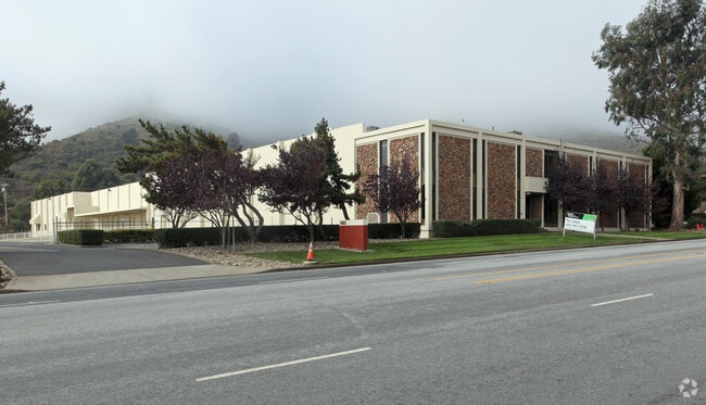
Property Record
483 Valley Dr, Brisbane, CA 94005


Current Lease Availabilities
NEARBY LISTINGS FOR SALE OR LEASE
Property Detail
483 Valley Dr
005-242-190
Tract #842 Crocker Industrial Park Unit
Miscellaneous
PARCEL 3 2.59 AC MOL PARCEL MAP VOL 14/26
X
San Mateo
06081C0035F
California
2024
2.58 AC
2025
Brisbane/Daly City
600100
San Francisco
56,512 SF
San Francisco-Redwood City-South San Francisco, CA
DEMOGRAPHICS near 483 Valley Dr
1 Mile
3 Mile
5 Mile
2024 Total Population
5,078
197,233
518,306
2029 Population
4,792
181,572
481,364
Pop Growth 2024-2029
(5.63%)
(7.94%)
(7.13%)
Average Age
42
43
42
2024 Total Households
1,597
58,767
177,196
HH Growth 2024-2029
(5.95%)
(8.20%)
(7.45%)
Median Household Inc
$116,690
$103,198
$120,650
Avg Household Size
3.00
3.20
2.80
2024 Avg HH Vehicles
2.00
2.00
2.00
Median Home Value
$1,045,579
$1,022,767
$1,070,316
Median Year Built
1990
1957
1956
Nearby Places
Map Layers
Map Styles
 Street
 Aerial
- Restaurants
- Banks
- Shops
- Fitness
- Groceries
PUBLIC TRANSPORTATION
COMMUTER RAIL
DRIVE
WALK
Distance
7 min
2.8 mi
South San Francisco (Caltrain - Caltrain (Caltrain))
DRIVE
WALK
Distance
South San Francisco (Caltrain - Caltrain (Caltrain))
8 min
4.1 mi
AIRPORT
San Francisco International
DRIVE
WALK
Distance
San Francisco International
14 min
7.6 mi
Metro Oakland International
DRIVE
WALK
Distance
Metro Oakland International
41 min
26.5 mi
Freight Ports
Port of San Francisco
DRIVE
WALK
Distance
Port of San Francisco
18 min
10.0 mi
Nearby Properties
Address
Land Use
TOTAL SIZE
Lot Size
Zoning
Address
Land Use
TOTAL SIZE
Lot Size
Zoning
Address
Land Use
TOTAL SIZE
Lot Size
Zoning
574,675 SF
10.07 AC
Address
Land Use
TOTAL SIZE
Lot Size
Zoning
8.97 AC
OA0000
Address
Land Use
TOTAL SIZE
Lot Size
Zoning
Address
Land Use
TOTAL SIZE
Lot Size
Zoning
350,036 SF
2.91 AC
Address
Land Use
TOTAL SIZE
Lot Size
Zoning
323,091 SF
14.83 AC
Address
Land Use
TOTAL SIZE
Lot Size
Zoning
Address
Land Use
TOTAL SIZE
Lot Size
Zoning
529,342 SF
5.28 AC
Address
Land Use
TOTAL SIZE
Lot Size
Zoning
161,850 SF
7.48 AC
Address
Land Use
TOTAL SIZE
Lot Size
Zoning
4,047 SF
4.25 AC
Address
Land Use
TOTAL SIZE
Lot Size
Zoning
293,445 SF
6.70 AC
MH00M2
Address
Land Use
TOTAL SIZE
Lot Size
Zoning
Address
Land Use
TOTAL SIZE
Lot Size
Zoning
152,145 SF
6.10 AC
MH00M2
Address
Land Use
TOTAL SIZE
Lot Size
Zoning
Address
Land Use
TOTAL SIZE
Lot Size
Zoning
176,096 SF
2.74 AC
Address
Land Use
TOTAL SIZE
Lot Size
Zoning
2,016 SF
3.61 AC
Address
Land Use
TOTAL SIZE
Lot Size
Zoning
2,007 SF
7.66 AC
Address
Land Use
TOTAL SIZE
Lot Size
Zoning
112,912 SF
5.96 AC
MH00M2
Address
Land Use
TOTAL SIZE
Lot Size
Zoning
346,710 SF
7.45 AC
RH2
Address
Land Use
TOTAL SIZE
Lot Size
Zoning
126,971 SF
3.04 AC
Address
Land Use
TOTAL SIZE
Lot Size
Zoning
Address
Land Use
TOTAL SIZE
Lot Size
Zoning
1,282,685 SF
21.15 AC
Address
Land Use
TOTAL SIZE
Lot Size
Zoning
2,008 SF
8.84 AC
Address
Land Use
TOTAL SIZE
Lot Size
Zoning
312,191 SF
2.74 AC
Address
Land Use
TOTAL SIZE
Lot Size
Zoning
141,360 SF
8.56 AC
Address
Land Use
TOTAL SIZE
Lot Size
Zoning
141,677 SF
8.57 AC
Address
Land Use
TOTAL SIZE
Lot Size
Zoning
210,895 SF
2.89 AC
Address
Land Use
TOTAL SIZE
Lot Size
Zoning
2,003 SF
4.88 AC
Address
Land Use
TOTAL SIZE
Lot Size
Zoning
321,315 SF
6.18 AC
Address
Land Use
TOTAL SIZE
Lot Size
Zoning
2,023 SF
2.98 AC
MH00M2
The World's #1 Commercial Real Estate Marketplace
Connect with us
© 2026 CoStar Group
The information above has been obtained from sources believed reliable. While we do not doubt its accuracy we have not verified it and make no guarantee, warranty or representation about it. It is your responsibility to independently confirm its accuracy and completeness. Any projections, opinions, assumptions, or estimates used are for example only and do not represent the current or future performance of the property. The value of this transaction to you depends on tax and other factors which should be evaluated by your tax, financial, and legal advisors. You and your advisors should conduct a careful, independent investigation of the property to determine to your satisfaction the suitability of the property for your needs.