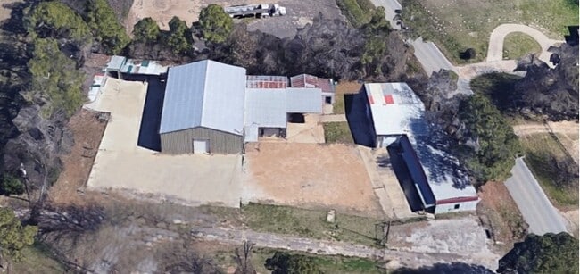
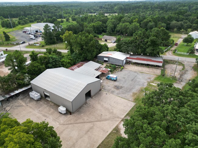
Property Record
4895 Fm 850, Tyler, TX 75705
Current Lease Availabilities
Property Detail
4895 Fm 850
1-00000-0191-01-056022
ABST A0191 P CHERINOTRACT 56B.2
Warehouse
SMITH
B and X Area of moderate flood hazard, usually the area between the limits of the 100-year and 500-year floods.
Texas
2025
0.69 AC
2025
Tyler
001806
Other Market Areas
5,500 SF
Tyler, TX
NEARBY LISTINGS FOR SALE OR LEASE
DEMOGRAPHICS near 4895 Fm 850
1 mile
3 mile
5 mile
2025 Total Population
1,483
39,273
94,908
2030 Population
1,571
41,518
100,036
Pop Growth 2025-2030
+ 5.93%
+ 5.72%
+ 5.40%
Average Age
35
36
37
2025 Total Households
550
13,818
35,186
HH Growth 2025-2030
+ 5.27%
+ 5.40%
+ 4.97%
Median Household Inc
$56,349
$56,210
$60,180
Avg Household Size
2.70
2.50
2.50
2025 Avg HH Vehicles
2.00
2.00
2.00
Median Home Value
$99,611
$181,156
$198,018
Median Year Built
1993
1967
1973
Nearby Places
Map Layers
Map Styles
 Street
 Aerial
Layers
 Traffic
 Biking
Places
Listings with unknown addresses are not visible on the map
- Restaurants
- Banks
- Shops
- Fitness
- Groceries
PUBLIC TRANSPORTATION
AIRPORT
Tyler Pounds Regional
Drive
Walk
Distance
Tyler Pounds Regional
20 min
11.0 mi
Freight Ports
Port of Shreveport
Drive
Walk
Distance
Port of Shreveport
119 min
105.9 mi
Nearby Properties
Address
Land Use
TOTAL SIZE
Lot Size
Zoning
Address
Land Use
TOTAL SIZE
Lot Size
Zoning
14,000 SF
144.13 AC
M2
Address
Land Use
TOTAL SIZE
Lot Size
Zoning
12.64 AC
Address
Land Use
TOTAL SIZE
Lot Size
Zoning
22,500 SF
214.44 AC
R1A
Address
Land Use
TOTAL SIZE
Lot Size
Zoning
503,620 SF
11.42 AC
Address
Land Use
TOTAL SIZE
Lot Size
Zoning
1.47 AC
RMF
Address
Land Use
TOTAL SIZE
Lot Size
Zoning
9.98 AC
Address
Land Use
TOTAL SIZE
Lot Size
Zoning
Address
Land Use
TOTAL SIZE
Lot Size
Zoning
Address
Land Use
TOTAL SIZE
Lot Size
Zoning
168,390 SF
7.51 AC
Address
Land Use
TOTAL SIZE
Lot Size
Zoning
Address
Land Use
TOTAL SIZE
Lot Size
Zoning
Address
Land Use
TOTAL SIZE
Lot Size
Zoning
37.07 AC
Address
Land Use
TOTAL SIZE
Lot Size
Zoning
16.53 AC
Address
Land Use
TOTAL SIZE
Lot Size
Zoning
1.78 AC
DBAC
Address
Land Use
TOTAL SIZE
Lot Size
Zoning
Address
Land Use
TOTAL SIZE
Lot Size
Zoning
448,500 SF
2.90 AC
INT
Address
Land Use
TOTAL SIZE
Lot Size
Zoning
238,658 SF
1.97 AC
INT
Address
Land Use
TOTAL SIZE
Lot Size
Zoning
25 AC
INT
Address
Land Use
TOTAL SIZE
Lot Size
Zoning
213,323 SF
1.21 AC
Address
Land Use
TOTAL SIZE
Lot Size
Zoning
2.40 AC
Address
Land Use
TOTAL SIZE
Lot Size
Zoning
Address
Land Use
TOTAL SIZE
Lot Size
Zoning
12,810 SF
12.07 AC
R1A
Address
Land Use
TOTAL SIZE
Lot Size
Zoning
20,071 SF
7.43 AC
Address
Land Use
TOTAL SIZE
Lot Size
Zoning
3,385 SF
10.50 AC
R1A
Address
Land Use
TOTAL SIZE
Lot Size
Zoning
8,279 SF
14.06 AC
RMF
Address
Land Use
TOTAL SIZE
Lot Size
Zoning
111,030 SF
1.02 AC
Address
Land Use
TOTAL SIZE
Lot Size
Zoning
2,676 SF
8.28 AC
RMF
Address
Land Use
TOTAL SIZE
Lot Size
Zoning
207,919 SF
1.90 AC
DBAC
Address
Land Use
TOTAL SIZE
Lot Size
Zoning
Address
Land Use
TOTAL SIZE
Lot Size
Zoning
83,450 SF
The World's #1 Commercial Real Estate Marketplace
Connect with us
© 2026 CoStar Group
The information above has been obtained from sources believed reliable. While we do not doubt its accuracy we have not verified it and make no guarantee, warranty or representation about it. It is your responsibility to independently confirm its accuracy and completeness. Any projections, opinions, assumptions, or estimates used are for example only and do not represent the current or future performance of the property. The value of this transaction to you depends on tax and other factors which should be evaluated by your tax, financial, and legal advisors. You and your advisors should conduct a careful, independent investigation of the property to determine to your satisfaction the suitability of the property for your needs.