Property Record
49 Saddle River Ave, South Hackensack, NJ 07606

Save to a Folder
{{folder.Name}}
{{folder.ListingIds.length}} Properties
{{folder.ListingIds.length}} Property
Create a New Folder
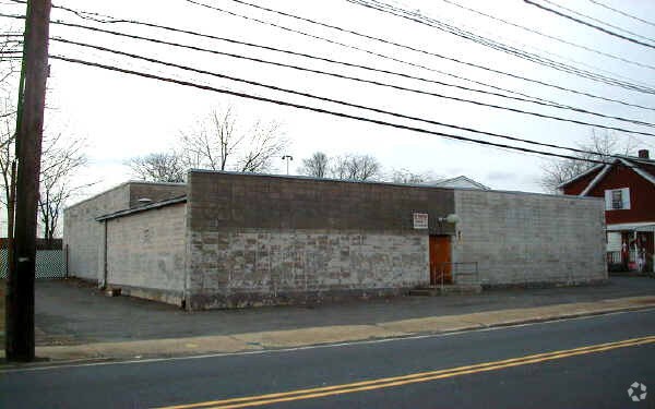
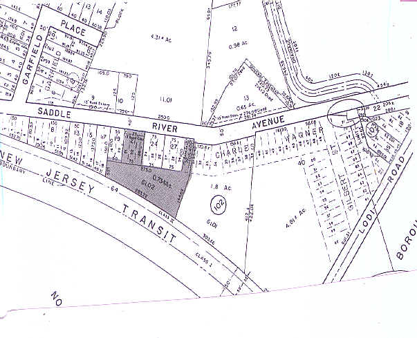
Property Detail
49 Saddle River Ave
New York-Jersey City-White Plains, NY-NJ
75 X 300 61.02
59-00102-0000-00021
BERGEN
Industrialgeneral
New Jersey
C
21
B and X Area of moderate flood hazard, usually the area between the limits of the 100-year and 500-year floods.
0.52 AC
2025
Teterboro Airport
2026
Northern New Jersey
036100
NEARBY LISTINGS FOR SALE OR LEASE
DEMOGRAPHICS near 49 Saddle River Ave
1 mile
3 mile
5 mile
2025 Total Population
41,481
273,828
606,508
2030 Population
41,820
276,377
616,986
Pop Growth 2025-2030
+ 0.82%
+ 0.93%
+ 1.73%
Average Age
38
39
40
2025 Total Households
15,061
95,956
217,029
HH Growth 2025-2030
+ 0.82%
+ 0.94%
+ 1.84%
Median Household Inc
$79,400
$81,862
$90,830
Avg Household Size
2.70
2.70
2.70
2025 Avg HH Vehicles
1.00
2.00
2.00
Median Home Value
$493,617
$484,535
$482,224
Median Year Built
1955
1953
1954
Nearby Places
Map Layers
Map Styles
 Street
 Aerial
Layers
 Traffic
 Biking
Places
Listings with unknown addresses are not visible on the map
- Restaurants
- Banks
- Shops
- Fitness
- Groceries
PUBLIC TRANSPORTATION
COMMUTER RAIL
Garfield (Bergen County/Port Jervis Line - NJ Transit Commuter Rail (NJ Transit))
Drive
Walk
Distance
Garfield (Bergen County/Port Jervis Line - NJ Transit Commuter Rail (NJ Transit))
2 min
9 min
0.5 mi
Drive
Walk
Distance
6 min
1.7 mi
AIRPORT
Newark Liberty International
Drive
Walk
Distance
Newark Liberty International
22 min
16.0 mi
LaGuardia
Drive
Walk
Distance
LaGuardia
36 min
20.9 mi
John F Kennedy International
Drive
Walk
Distance
John F Kennedy International
50 min
32.0 mi
Freight Ports
Maher Terminal
Drive
Walk
Distance
Maher Terminal
29 min
17.6 mi
Nearby Properties
Address
Land Use
TOTAL SIZE
Lot Size
Zoning
Address
Land Use
TOTAL SIZE
Lot Size
Zoning
488,779 SF
7.55 AC
HCS
Address
Land Use
TOTAL SIZE
Lot Size
Zoning
612 AC
SEA
Address
Land Use
TOTAL SIZE
Lot Size
Zoning
335.71 AC
AF
Address
Land Use
TOTAL SIZE
Lot Size
Zoning
Address
Land Use
TOTAL SIZE
Lot Size
Zoning
4,014 SF
21 AC
Address
Land Use
TOTAL SIZE
Lot Size
Zoning
Address
Land Use
TOTAL SIZE
Lot Size
Zoning
9.57 AC
I2
Address
Land Use
TOTAL SIZE
Lot Size
Zoning
4.37 AC
HCS
Address
Land Use
TOTAL SIZE
Lot Size
Zoning
281,720 SF
3.93 AC
R-3
Address
Land Use
TOTAL SIZE
Lot Size
Zoning
7.10 AC
R-3
Address
Land Use
TOTAL SIZE
Lot Size
Zoning
82.74 AC
Address
Land Use
TOTAL SIZE
Lot Size
Zoning
Address
Land Use
TOTAL SIZE
Lot Size
Zoning
8.66 AC
CH1
Address
Land Use
TOTAL SIZE
Lot Size
Zoning
608,596 SF
27.10 AC
LID
Address
Land Use
TOTAL SIZE
Lot Size
Zoning
30.46 AC
I
Address
Land Use
TOTAL SIZE
Lot Size
Zoning
Address
Land Use
TOTAL SIZE
Lot Size
Zoning
7.29 AC
Address
Land Use
TOTAL SIZE
Lot Size
Zoning
221,229 SF
8.51 AC
LID
Address
Land Use
TOTAL SIZE
Lot Size
Zoning
394,046 SF
1.88 AC
R3
Address
Land Use
TOTAL SIZE
Lot Size
Zoning
31,896 SF
1.64 AC
O
Address
Land Use
TOTAL SIZE
Lot Size
Zoning
18.30 AC
Address
Land Use
TOTAL SIZE
Lot Size
Zoning
25.50 AC
B2
Address
Land Use
TOTAL SIZE
Lot Size
Zoning
431,600 SF
2.70 AC
R3
Address
Land Use
TOTAL SIZE
Lot Size
Zoning
2.42 AC
Address
Land Use
TOTAL SIZE
Lot Size
Zoning
431,600 SF
2.84 AC
R3
Address
Land Use
TOTAL SIZE
Lot Size
Zoning
24.29 AC
Address
Land Use
TOTAL SIZE
Lot Size
Zoning
286,500 SF
26.90 AC
LL
Address
Land Use
TOTAL SIZE
Lot Size
Zoning
16.94 AC
R2
Address
Land Use
TOTAL SIZE
Lot Size
Zoning
24.35 AC
Address
Land Use
TOTAL SIZE
Lot Size
Zoning
148,918 SF
4.17 AC
B
The World's #1 Commercial Real Estate Marketplace
Connect with us
© 2026 CoStar Group
The information above has been obtained from sources believed reliable. While we do not doubt its accuracy we have not verified it and make no guarantee, warranty or representation about it. It is your responsibility to independently confirm its accuracy and completeness. Any projections, opinions, assumptions, or estimates used are for example only and do not represent the current or future performance of the property. The value of this transaction to you depends on tax and other factors which should be evaluated by your tax, financial, and legal advisors. You and your advisors should conduct a careful, independent investigation of the property to determine to your satisfaction the suitability of the property for your needs.