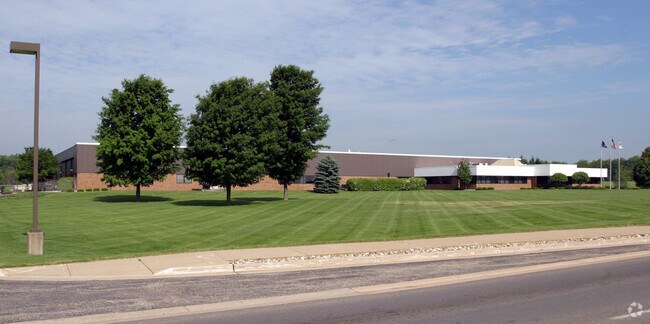
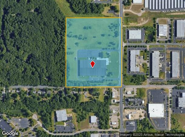
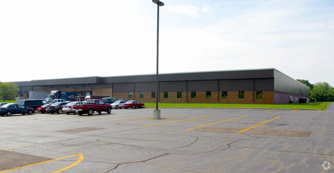
Property Record
4900 S 9Th St, Kalamazoo, MI 49009
NEARBY LISTINGS FOR SALE OR LEASE
Property Detail
4900 S 9Th St
05-35-380-051
SEC 35-2-12 SE 1/4 SW 1/4 EXC W 250 FT. COMBINED IN 2000 FROM 35-380-050 & 35-380-080
Industrialgeneral
Kalamazoo
X
Michigan
26077C0285E
33.48 AC
2025
Western Kalamazoo County
2025
West Michigan
002910
Kalamazoo-Portage, MI
161,833 SF
DEMOGRAPHICS near 4900 S 9Th St
1 Mile
3 Mile
5 Mile
2024 Total Population
2,652
36,086
107,203
2029 Population
2,646
35,973
107,009
Pop Growth 2024-2029
(0.23%)
(0.31%)
(0.18%)
Average Age
41
37
37
2024 Total Households
1,153
15,141
43,554
HH Growth 2024-2029
(0.17%)
(0.37%)
(0.20%)
Median Household Inc
$63,358
$63,233
$64,945
Avg Household Size
2.30
2.30
2.30
2024 Avg HH Vehicles
2.00
2.00
2.00
Median Home Value
$271,088
$266,672
$246,506
Median Year Built
1993
1989
1980
Nearby Places
Map Layers
Map Styles
 Street
 Aerial
- Restaurants
- Banks
- Shops
- Fitness
- Groceries
PUBLIC TRANSPORTATION
COMMUTER RAIL
DRIVE
WALK
Distance
14 min
6.8 mi
AIRPORT
Kalamazoo/Battle Creek International
DRIVE
WALK
Distance
Kalamazoo/Battle Creek International
17 min
8.9 mi
Nearby Properties
Address
Land Use
TOTAL SIZE
Lot Size
Zoning
Address
Land Use
TOTAL SIZE
Lot Size
Zoning
1,703 SF
20.29 AC
R-2
Address
Land Use
TOTAL SIZE
Lot Size
Zoning
204,579 SF
27.80 AC
R-4 MUL
Address
Land Use
TOTAL SIZE
Lot Size
Zoning
424,967 SF
55.60 AC
I-1
Address
Land Use
TOTAL SIZE
Lot Size
Zoning
449,275 SF
33.70 AC
R-4 MUL
Address
Land Use
TOTAL SIZE
Lot Size
Zoning
331,571 SF
19.68 AC
RM-15
Address
Land Use
TOTAL SIZE
Lot Size
Zoning
304,247 SF
44.91 AC
R-4 MUL
Address
Land Use
TOTAL SIZE
Lot Size
Zoning
17.31 AC
PD
Address
Land Use
TOTAL SIZE
Lot Size
Zoning
447,142 SF
34.79 AC
R-4 MUL
Address
Land Use
TOTAL SIZE
Lot Size
Zoning
126.09 AC
R-5 MHP
Address
Land Use
TOTAL SIZE
Lot Size
Zoning
140,000 SF
22.69 AC
EBT
Address
Land Use
TOTAL SIZE
Lot Size
Zoning
55.46 AC
R-5 MHP
Address
Land Use
TOTAL SIZE
Lot Size
Zoning
230,820 SF
16.50 AC
R-4 MUL
Address
Land Use
TOTAL SIZE
Lot Size
Zoning
128,586 SF
14.27 AC
R-4 MUL
Address
Land Use
TOTAL SIZE
Lot Size
Zoning
5,173 SF
15.81 AC
RM-1
Address
Land Use
TOTAL SIZE
Lot Size
Zoning
4.33 AC
C-1
Address
Land Use
TOTAL SIZE
Lot Size
Zoning
235,227 SF
25.18 AC
R-4 MUL
Address
Land Use
TOTAL SIZE
Lot Size
Zoning
224,424 SF
18.89 AC
R-4 MUL
Address
Land Use
TOTAL SIZE
Lot Size
Zoning
23,463 SF
15 AC
PD
Address
Land Use
TOTAL SIZE
Lot Size
Zoning
12,480 SF
14.82 AC
RM-1
Address
Land Use
TOTAL SIZE
Lot Size
Zoning
8.83 AC
I-1
Address
Land Use
TOTAL SIZE
Lot Size
Zoning
178,882 SF
10.02 AC
RS-5
Address
Land Use
TOTAL SIZE
Lot Size
Zoning
153,637 SF
12.28 AC
PUD
Address
Land Use
TOTAL SIZE
Lot Size
Zoning
161,530 SF
10.01 AC
RM-15
Address
Land Use
TOTAL SIZE
Lot Size
Zoning
115,455 SF
15.09 AC
CBTR
Address
Land Use
TOTAL SIZE
Lot Size
Zoning
124,845 SF
12.65 AC
RM-15
Address
Land Use
TOTAL SIZE
Lot Size
Zoning
92,694 SF
16.10 AC
EBT
Address
Land Use
TOTAL SIZE
Lot Size
Zoning
61,915 SF
6.93 AC
R-4 MUL
Address
Land Use
TOTAL SIZE
Lot Size
Zoning
50.10 AC
C-3
Address
Land Use
TOTAL SIZE
Lot Size
Zoning
141,600 SF
6.83 AC
R-4 MUL
Address
Land Use
TOTAL SIZE
Lot Size
Zoning
146,211 SF
16.37 AC
C COMM
The World's #1 Commercial Real Estate Marketplace
Connect with us
© 2026 CoStar Group
The information above has been obtained from sources believed reliable. While we do not doubt its accuracy we have not verified it and make no guarantee, warranty or representation about it. It is your responsibility to independently confirm its accuracy and completeness. Any projections, opinions, assumptions, or estimates used are for example only and do not represent the current or future performance of the property. The value of this transaction to you depends on tax and other factors which should be evaluated by your tax, financial, and legal advisors. You and your advisors should conduct a careful, independent investigation of the property to determine to your satisfaction the suitability of the property for your needs.