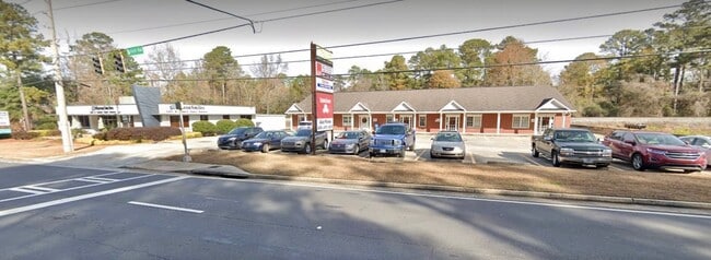
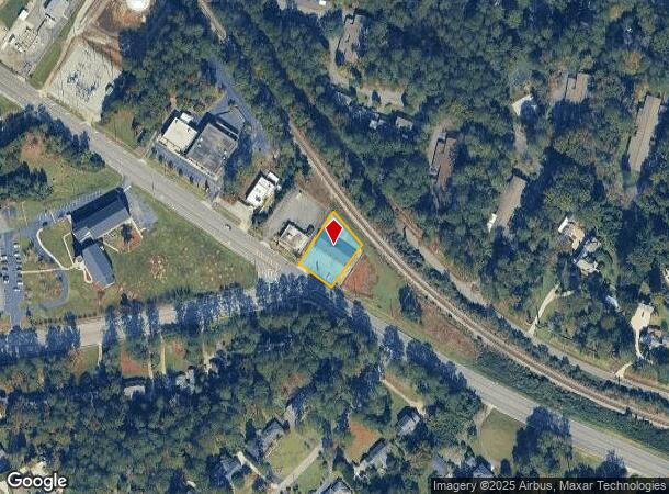
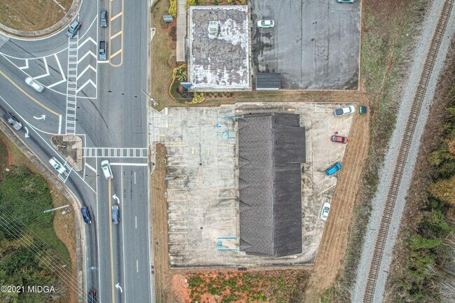
Property Record
4909 Forsyth Rd, Macon, GA 31210

NEARBY LISTINGS FOR SALE OR LEASE
-
-
-
-
-
-
-
No Photo
-
View all Macon listings for sale on LoopNet.com
Property Detail
4909 Forsyth Rd
Officebuilding
Bibb
X
Georgia
13169C0215E
0.56 AC
2025
Outlying Bibb County
2025
Atlanta
013412
Macon-Bibb County, GA
5,474 SF
L053-0063
DEMOGRAPHICS near 4909 Forsyth Rd
1 Mile
3 Mile
5 Mile
2024 Total Population
3,680
31,947
73,169
2029 Population
3,574
31,279
72,351
Pop Growth 2024-2029
(2.88%)
(2.09%)
(1.12%)
Average Age
44
40
39
2024 Total Households
1,447
13,362
30,674
HH Growth 2024-2029
(2.90%)
(2.08%)
(1.17%)
Median Household Inc
$109,529
$72,387
$60,404
Avg Household Size
2.40
2.30
2.30
2024 Avg HH Vehicles
2.00
2.00
2.00
Median Home Value
$242,699
$198,726
$179,340
Median Year Built
1984
1986
1982
Nearby Places
Map Layers
Map Styles
 Street
 Aerial
- Restaurants
- Banks
- Shops
- Fitness
- Groceries
SALE & LEASE HISTORY
LISTING DATE
SALE/LEASE

Feb 14, 2023
For Sale
Nearby Properties
Address
Land Use
TOTAL SIZE
Lot Size
Zoning
Address
Land Use
TOTAL SIZE
Lot Size
Zoning
Address
Land Use
TOTAL SIZE
Lot Size
Zoning
196,702 SF
37.72 AC
PDE
Address
Land Use
TOTAL SIZE
Lot Size
Zoning
3,204 SF
49.78 AC
R-3
Address
Land Use
TOTAL SIZE
Lot Size
Zoning
83,104 SF
20.39 AC
PDE
Address
Land Use
TOTAL SIZE
Lot Size
Zoning
4,671 SF
22.66 AC
R-3
Address
Land Use
TOTAL SIZE
Lot Size
Zoning
6,222 SF
56.17 AC
PDR
Address
Land Use
TOTAL SIZE
Lot Size
Zoning
194,734 SF
6.37 AC
C-2
Address
Land Use
TOTAL SIZE
Lot Size
Zoning
5,684 SF
29.99 AC
PDE
Address
Land Use
TOTAL SIZE
Lot Size
Zoning
22,421 SF
13.60 AC
PDE
Address
Land Use
TOTAL SIZE
Lot Size
Zoning
98,912 SF
13.95 AC
PDE
Address
Land Use
TOTAL SIZE
Lot Size
Zoning
71,021 SF
8.94 AC
PDC
Address
Land Use
TOTAL SIZE
Lot Size
Zoning
59,801 SF
28.03 AC
PDE
Address
Land Use
TOTAL SIZE
Lot Size
Zoning
5,270 SF
20 AC
Address
Land Use
TOTAL SIZE
Lot Size
Zoning
231,774 SF
21.27 AC
R-1AAA
Address
Land Use
TOTAL SIZE
Lot Size
Zoning
214,685 SF
18.69 AC
C-2
Address
Land Use
TOTAL SIZE
Lot Size
Zoning
51,786 SF
21.05 AC
PDR
Address
Land Use
TOTAL SIZE
Lot Size
Zoning
20,544 SF
62.02 AC
A
Address
Land Use
TOTAL SIZE
Lot Size
Zoning
55,536 SF
20.36 AC
PDE
Address
Land Use
TOTAL SIZE
Lot Size
Zoning
5,376 SF
102.72 AC
R-1AA
Address
Land Use
TOTAL SIZE
Lot Size
Zoning
2,070 SF
24.17 AC
PDR
Address
Land Use
TOTAL SIZE
Lot Size
Zoning
1,039 SF
14.79 AC
PDR
Address
Land Use
TOTAL SIZE
Lot Size
Zoning
1,452 SF
12.16 AC
R-3
Address
Land Use
TOTAL SIZE
Lot Size
Zoning
6,720 SF
16.69 AC
PDR
Address
Land Use
TOTAL SIZE
Lot Size
Zoning
4,030 SF
11.99 AC
A
Address
Land Use
TOTAL SIZE
Lot Size
Zoning
211,781 SF
22.45 AC
PDE
Address
Land Use
TOTAL SIZE
Lot Size
Zoning
2,366 SF
14.46 AC
PDE
Address
Land Use
TOTAL SIZE
Lot Size
Zoning
125,073 SF
4.89 AC
R-3
Address
Land Use
TOTAL SIZE
Lot Size
Zoning
79,904 SF
5.05 AC
PDE
Address
Land Use
TOTAL SIZE
Lot Size
Zoning
135,820 SF
20 AC
PDE
Address
Land Use
TOTAL SIZE
Lot Size
Zoning
75,452 SF
2.03 AC
C-2
The World's #1 Commercial Real Estate Marketplace
Connect with us
© 2025 CoStar Group
The information above has been obtained from sources believed reliable. While we do not doubt its accuracy we have not verified it and make no guarantee, warranty or representation about it. It is your responsibility to independently confirm its accuracy and completeness. Any projections, opinions, assumptions, or estimates used are for example only and do not represent the current or future performance of the property. The value of this transaction to you depends on tax and other factors which should be evaluated by your tax, financial, and legal advisors. You and your advisors should conduct a careful, independent investigation of the property to determine to your satisfaction the suitability of the property for your needs.