Property Record
50 Cantrell Ave, Middletown, NY 10940
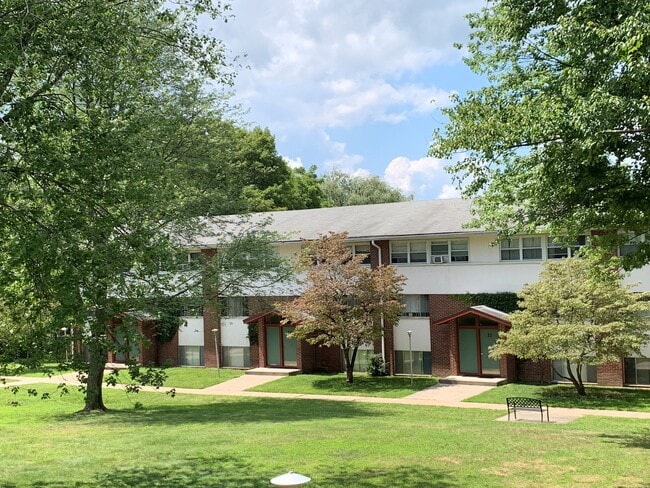

Property Detail
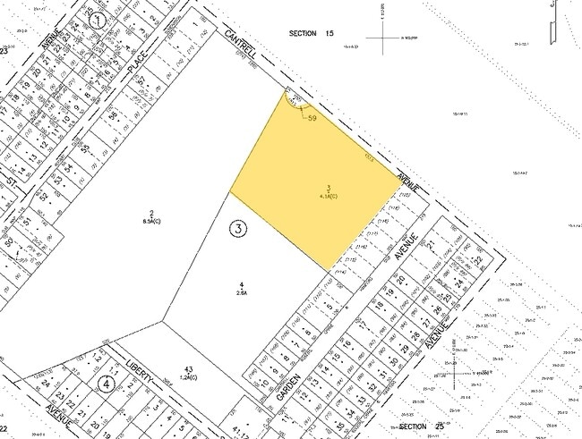
50 Cantrell Ave
330900-024-000-0003-003.000-0000
Orange
Apartment
New York
SR-3B
3.000
B and X Area of moderate flood hazard, usually the area between the limits of the 100-year and 500-year floods.
4.10 AC
2024
Middletown/Goshen
2025
Northern New Jersey
015100
Kiryas Joel-Poughkeepsie-Newburgh, NY
NEARBY LISTINGS FOR SALE OR LEASE
-
-
View all Middletown listings for sale on LoopNet.com
DEMOGRAPHICS near 50 Cantrell Ave
1 mile
3 mile
5 mile
2025 Total Population
17,388
48,159
67,449
2030 Population
17,546
48,967
68,684
Pop Growth 2025-2030
+ 0.91%
+ 1.68%
+ 1.83%
Average Age
38
39
40
2025 Total Households
6,064
18,059
24,643
HH Growth 2025-2030
+ 1.01%
+ 1.83%
+ 1.98%
Median Household Inc
$77,373
$82,029
$87,241
Avg Household Size
2.70
2.60
2.60
2025 Avg HH Vehicles
2.00
2.00
2.00
Median Home Value
$290,386
$324,834
$343,553
Median Year Built
1948
1973
1975
Nearby Places
Map Layers
Map Styles
 Street
 Aerial
Layers
 Traffic
 Biking
Places
Listings with unknown addresses are not visible on the map
- Restaurants
- Banks
- Shops
- Fitness
- Groceries
PUBLIC TRANSPORTATION
COMMUTER RAIL
Middletown New York (Bergen County/Port Jervis Line - NJ Transit Commuter Rail (NJ Transit), Main/Port Jervis Line - NJ Transit Commuter Rail (NJ Transit))
Drive
Walk
Distance
Middletown New York (Bergen County/Port Jervis Line - NJ Transit Commuter Rail (NJ Transit), Main/Port Jervis Line - NJ Transit Commuter Rail (NJ Transit))
9 min
3.6 mi
Otisville (Bergen County/Port Jervis Line - NJ Transit Commuter Rail (NJ Transit), Main/Port Jervis Line - NJ Transit Commuter Rail (NJ Transit))
Drive
Walk
Distance
Otisville (Bergen County/Port Jervis Line - NJ Transit Commuter Rail (NJ Transit), Main/Port Jervis Line - NJ Transit Commuter Rail (NJ Transit))
12 min
7.3 mi
AIRPORT
New York Stewart International
Drive
Walk
Distance
New York Stewart International
34 min
22.3 mi
Freight Ports
Port Newark Container Terminal
Drive
Walk
Distance
Port Newark Container Terminal
98 min
72.9 mi
Nearby Properties
Address
Land Use
TOTAL SIZE
Lot Size
Zoning
Address
Land Use
TOTAL SIZE
Lot Size
Zoning
72.50 AC
MC 1
Address
Land Use
TOTAL SIZE
Lot Size
Zoning
Address
Land Use
TOTAL SIZE
Lot Size
Zoning
159,120 SF
90.20 AC
SR-RH
Address
Land Use
TOTAL SIZE
Lot Size
Zoning
40.40 AC
I-2
Address
Land Use
TOTAL SIZE
Lot Size
Zoning
698,289 SF
52.20 AC
Address
Land Use
TOTAL SIZE
Lot Size
Zoning
180,840 SF
37.50 AC
TC
Address
Land Use
TOTAL SIZE
Lot Size
Zoning
24.40 AC
R-1
Address
Land Use
TOTAL SIZE
Lot Size
Zoning
376,002 SF
34.40 AC
TC
Address
Land Use
TOTAL SIZE
Lot Size
Zoning
17.60 AC
R-1
Address
Land Use
TOTAL SIZE
Lot Size
Zoning
Address
Land Use
TOTAL SIZE
Lot Size
Zoning
14.70 AC
MC 1
Address
Land Use
TOTAL SIZE
Lot Size
Zoning
29,950 SF
3 AC
TC-1
Address
Land Use
TOTAL SIZE
Lot Size
Zoning
50,700 SF
7.70 AC
TC-1
Address
Land Use
TOTAL SIZE
Lot Size
Zoning
142,416 SF
13.90 AC
R1
Address
Land Use
TOTAL SIZE
Lot Size
Zoning
289,910 SF
19.90 AC
TC
Address
Land Use
TOTAL SIZE
Lot Size
Zoning
26,156 SF
0.01 AC
TC-1
Address
Land Use
TOTAL SIZE
Lot Size
Zoning
5,832 SF
2.30 AC
TC-1
Address
Land Use
TOTAL SIZE
Lot Size
Zoning
270,471 SF
78.40 AC
R1
Address
Land Use
TOTAL SIZE
Lot Size
Zoning
5,753 SF
18 AC
TC
Address
Land Use
TOTAL SIZE
Lot Size
Zoning
208,464 SF
24.90 AC
HC
Address
Land Use
TOTAL SIZE
Lot Size
Zoning
141,454 SF
12 AC
TC
Address
Land Use
TOTAL SIZE
Lot Size
Zoning
57.40 AC
MC 1
Address
Land Use
TOTAL SIZE
Lot Size
Zoning
7 AC
C-3
Address
Land Use
TOTAL SIZE
Lot Size
Zoning
6.80 AC
MC 1
Address
Land Use
TOTAL SIZE
Lot Size
Zoning
83,832 SF
4.20 AC
TC
Address
Land Use
TOTAL SIZE
Lot Size
Zoning
96,231 SF
14.80 AC
HC
Address
Land Use
TOTAL SIZE
Lot Size
Zoning
41,728 SF
5 AC
TC-1
Address
Land Use
TOTAL SIZE
Lot Size
Zoning
53,964 SF
4.50 AC
O/R
Address
Land Use
TOTAL SIZE
Lot Size
Zoning
87,090 SF
4.50 AC
TC
Address
Land Use
TOTAL SIZE
Lot Size
Zoning
89,376 SF
5.40 AC
HC
The World's #1 Commercial Real Estate Marketplace
Connect with us
© 2026 CoStar Group
The information above has been obtained from sources believed reliable. While we do not doubt its accuracy we have not verified it and make no guarantee, warranty or representation about it. It is your responsibility to independently confirm its accuracy and completeness. Any projections, opinions, assumptions, or estimates used are for example only and do not represent the current or future performance of the property. The value of this transaction to you depends on tax and other factors which should be evaluated by your tax, financial, and legal advisors. You and your advisors should conduct a careful, independent investigation of the property to determine to your satisfaction the suitability of the property for your needs.