Property Record
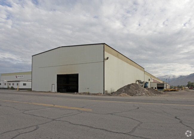
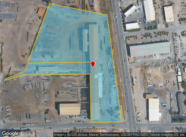
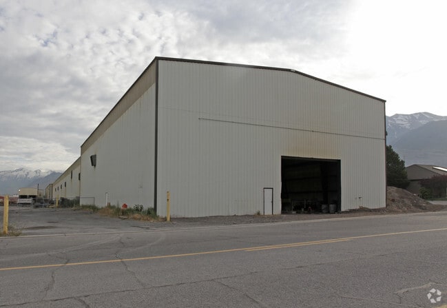
50 N Geneva Rd, Lindon, UT 84042
NEARBY LISTINGS FOR SALE OR LEASE
Property Detail
50 N Geneva Rd
Provo-Orem-Lehi, UT
COM N 1636.78 FT & E 875.27 FT FR S1/4 COR SEC 32, T5S, R2E, SLM; N 5137W 591.25 FT; S 89 DEG 0823W 613.24 FT; N 20 DEG 4345E 621.16 FT; S 78 DEG 5522E 572.68 FT; S 7 DEG 4718E 1058.10 FT; S 89 DEG 0823W 303.23 FT TO BEG. ALSO: COM N 2060.224 FT & E
14-065-0024
Utah
Lightindustrial
Utah
2024
13.90 AC
2025
Utah County
000601
Salt Lake City
107,594 SF
DEMOGRAPHICS near 50 N Geneva Rd
1 Mile
3 Mile
5 Mile
2024 Total Population
3,903
90,803
188,494
2029 Population
4,662
106,033
220,139
Pop Growth 2024-2029
+ 19.45%
+ 16.77%
+ 16.79%
Average Age
34
32
32
2024 Total Households
1,176
27,864
56,745
HH Growth 2024-2029
+ 19.73%
+ 17.36%
+ 17.29%
Median Household Inc
$72,499
$82,601
$82,417
Avg Household Size
3.40
3.20
3.20
2024 Avg HH Vehicles
2.00
2.00
2.00
Median Home Value
$491,771
$431,265
$444,871
Median Year Built
2010
2000
1996
Nearby Places
Map Layers
Map Styles
 Street
 Aerial
- Restaurants
- Banks
- Shops
- Fitness
- Groceries
PUBLIC TRANSPORTATION
COMMUTER RAIL
DRIVE
WALK
Distance
6 min
2.8 mi
DRIVE
WALK
Distance
10 min
4.6 mi
AIRPORT
Provo Municipal
DRIVE
WALK
Distance
Provo Municipal
17 min
11.2 mi
Salt Lake City International
DRIVE
WALK
Distance
Salt Lake City International
50 min
41.6 mi
Nearby Properties
Address
Land Use
TOTAL SIZE
Lot Size
Zoning
Address
Land Use
TOTAL SIZE
Lot Size
Zoning
587,192 SF
48.27 AC
Address
Land Use
TOTAL SIZE
Lot Size
Zoning
206,178 SF
16.64 AC
Address
Land Use
TOTAL SIZE
Lot Size
Zoning
472,365 SF
15.90 AC
Address
Land Use
TOTAL SIZE
Lot Size
Zoning
296,420 SF
19.66 AC
Address
Land Use
TOTAL SIZE
Lot Size
Zoning
287,823 SF
8.96 AC
Address
Land Use
TOTAL SIZE
Lot Size
Zoning
201,081 SF
17.96 AC
Address
Land Use
TOTAL SIZE
Lot Size
Zoning
400,684 SF
10.39 AC
Address
Land Use
TOTAL SIZE
Lot Size
Zoning
322,826 SF
9.53 AC
Address
Land Use
TOTAL SIZE
Lot Size
Zoning
21,510 SF
6.66 AC
Address
Land Use
TOTAL SIZE
Lot Size
Zoning
291,932 SF
8.10 AC
Address
Land Use
TOTAL SIZE
Lot Size
Zoning
194,977 SF
8.18 AC
Address
Land Use
TOTAL SIZE
Lot Size
Zoning
233,302 SF
15.03 AC
Address
Land Use
TOTAL SIZE
Lot Size
Zoning
333,719 SF
11.99 AC
Address
Land Use
TOTAL SIZE
Lot Size
Zoning
230,702 SF
11.85 AC
Address
Land Use
TOTAL SIZE
Lot Size
Zoning
171,905 SF
6.62 AC
Address
Land Use
TOTAL SIZE
Lot Size
Zoning
327,092 SF
14.61 AC
Address
Land Use
TOTAL SIZE
Lot Size
Zoning
144,310 SF
6.85 AC
Address
Land Use
TOTAL SIZE
Lot Size
Zoning
146,939 SF
36.63 AC
Address
Land Use
TOTAL SIZE
Lot Size
Zoning
144,456 SF
5.55 AC
Address
Land Use
TOTAL SIZE
Lot Size
Zoning
333,724 SF
13.12 AC
Address
Land Use
TOTAL SIZE
Lot Size
Zoning
268,989 SF
12.78 AC
Address
Land Use
TOTAL SIZE
Lot Size
Zoning
8.99 AC
Address
Land Use
TOTAL SIZE
Lot Size
Zoning
Address
Land Use
TOTAL SIZE
Lot Size
Zoning
154,800 SF
9.14 AC
Address
Land Use
TOTAL SIZE
Lot Size
Zoning
364,248 SF
22.77 AC
Address
Land Use
TOTAL SIZE
Lot Size
Zoning
269,768 SF
14.94 AC
Address
Land Use
TOTAL SIZE
Lot Size
Zoning
194,852 SF
10.03 AC
Address
Land Use
TOTAL SIZE
Lot Size
Zoning
213,863 SF
11.71 AC
Address
Land Use
TOTAL SIZE
Lot Size
Zoning
141,635 SF
10.58 AC
Address
Land Use
TOTAL SIZE
Lot Size
Zoning
212,466 SF
25.89 AC
The World's #1 Commercial Real Estate Marketplace
Connect with us
© 2026 CoStar Group
The information above has been obtained from sources believed reliable. While we do not doubt its accuracy we have not verified it and make no guarantee, warranty or representation about it. It is your responsibility to independently confirm its accuracy and completeness. Any projections, opinions, assumptions, or estimates used are for example only and do not represent the current or future performance of the property. The value of this transaction to you depends on tax and other factors which should be evaluated by your tax, financial, and legal advisors. You and your advisors should conduct a careful, independent investigation of the property to determine to your satisfaction the suitability of the property for your needs.