Property Record
50 Rogers St, Gloucester, MA 01930
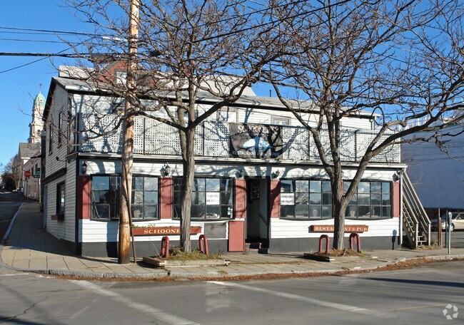

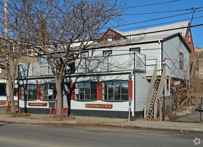
Property Detail
50 Rogers St
Commercialofficeresidentialmixeduse
Essex
CB
Massachusetts
B and X Area of moderate flood hazard, usually the area between the limits of the 100-year and 500-year floods.
0.09 AC
2025
Essex/Gloucester
2025
Boston
221500
Boston-Cambridge-Newton, MA-NH
5,117 SF
GLOU-000008-000047
NEARBY LISTINGS FOR SALE OR LEASE
DEMOGRAPHICS near 50 Rogers St
1 mile
3 mile
5 mile
2025 Total Population
13,696
26,513
41,793
2030 Population
13,946
27,389
43,508
Pop Growth 2025-2030
+ 1.83%
+ 3.30%
+ 4.10%
Average Age
44
46
47
2025 Total Households
6,348
11,836
18,732
HH Growth 2025-2030
+ 1.76%
+ 3.22%
+ 4.06%
Median Household Inc
$69,523
$85,747
$92,225
Avg Household Size
2.10
2.20
2.20
2025 Avg HH Vehicles
1.00
2.00
2.00
Median Home Value
$576,072
$697,856
$737,263
Median Year Built
1947
1949
1950
Nearby Places
Map Layers
Map Styles
 Street
 Aerial
Layers
 Traffic
 Biking
Places
Listings with unknown addresses are not visible on the map
- Restaurants
- Banks
- Shops
- Fitness
- Groceries
PUBLIC TRANSPORTATION
TRANSIT/SUBWAY
Gloucester (Newburyport/Rockport Line - Massachusetts Bay Transportation Authority Commuter Rail (Purple Line))
Drive
Walk
Distance
Gloucester (Newburyport/Rockport Line - Massachusetts Bay Transportation Authority Commuter Rail (Purple Line))
2 min
10 min
0.5 mi
COMMUTER RAIL
Gloucester (Newburyport/Rockport Line - Massachusetts Bay Transportation Authority Commuter Rail (Purple Line))
Drive
Walk
Distance
Gloucester (Newburyport/Rockport Line - Massachusetts Bay Transportation Authority Commuter Rail (Purple Line))
2 min
10 min
0.5 mi
West Gloucester (Newburyport/Rockport Line - Massachusetts Bay Transportation Authority Commuter Rail (Purple Line))
Drive
Walk
Distance
West Gloucester (Newburyport/Rockport Line - Massachusetts Bay Transportation Authority Commuter Rail (Purple Line))
5 min
2.5 mi
AIRPORT
General Edward Lawrence Logan International
Drive
Walk
Distance
General Edward Lawrence Logan International
52 min
31.1 mi
Portsmouth International at Pease
Drive
Walk
Distance
Portsmouth International at Pease
72 min
47.7 mi
Freight Ports
Port of Boston
Drive
Walk
Distance
Port of Boston
57 min
38.1 mi
Nearby Properties
Address
Land Use
TOTAL SIZE
Lot Size
Zoning
Address
Land Use
TOTAL SIZE
Lot Size
Zoning
187,125 SF
6.22 AC
R-10
Address
Land Use
TOTAL SIZE
Lot Size
Zoning
246,863 SF
18.84 AC
R-20
Address
Land Use
TOTAL SIZE
Lot Size
Zoning
17.56 AC
R-10
Address
Land Use
TOTAL SIZE
Lot Size
Zoning
86,922 SF
7.25 AC
R-20
Address
Land Use
TOTAL SIZE
Lot Size
Zoning
31.17 AC
EB
Address
Land Use
TOTAL SIZE
Lot Size
Zoning
11,513 SF
17.50 AC
R-20
Address
Land Use
TOTAL SIZE
Lot Size
Zoning
60,000 SF
9.91 AC
R-10
Address
Land Use
TOTAL SIZE
Lot Size
Zoning
1,834 SF
23.45 AC
R-10
Address
Land Use
TOTAL SIZE
Lot Size
Zoning
67,972 SF
20.94 AC
R-20
Address
Land Use
TOTAL SIZE
Lot Size
Zoning
19.43 AC
BP
Address
Land Use
TOTAL SIZE
Lot Size
Zoning
85,464 SF
1.85 AC
MI
Address
Land Use
TOTAL SIZE
Lot Size
Zoning
20,109 SF
30.81 AC
RC-40
Address
Land Use
TOTAL SIZE
Lot Size
Zoning
19.26 AC
BP
Address
Land Use
TOTAL SIZE
Lot Size
Zoning
99,838 SF
7.48 AC
BP
Address
Land Use
TOTAL SIZE
Lot Size
Zoning
1,872 SF
54.90 AC
R-10
Address
Land Use
TOTAL SIZE
Lot Size
Zoning
59,161 SF
5.12 AC
EB
Address
Land Use
TOTAL SIZE
Lot Size
Zoning
8.42 AC
EB
Address
Land Use
TOTAL SIZE
Lot Size
Zoning
14,493 SF
3.98 AC
R-5
Address
Land Use
TOTAL SIZE
Lot Size
Zoning
66,657 SF
0.77 AC
R-5
Address
Land Use
TOTAL SIZE
Lot Size
Zoning
47,350 SF
3.52 AC
BP
Address
Land Use
TOTAL SIZE
Lot Size
Zoning
2.60 AC
MI
Address
Land Use
TOTAL SIZE
Lot Size
Zoning
158,752 SF
10.38 AC
BP
Address
Land Use
TOTAL SIZE
Lot Size
Zoning
1.49 AC
R-5
Address
Land Use
TOTAL SIZE
Lot Size
Zoning
14,042 SF
12 AC
R-20
Address
Land Use
TOTAL SIZE
Lot Size
Zoning
14,914 SF
2.25 AC
RC-40
Address
Land Use
TOTAL SIZE
Lot Size
Zoning
71,950 SF
1 AC
CCD
Address
Land Use
TOTAL SIZE
Lot Size
Zoning
65,108 SF
7.37 AC
EB
Address
Land Use
TOTAL SIZE
Lot Size
Zoning
138,050 SF
2.63 AC
MI
Address
Land Use
TOTAL SIZE
Lot Size
Zoning
56,266 SF
9.59 AC
BP
Address
Land Use
TOTAL SIZE
Lot Size
Zoning
12,028 SF
0.75 AC
RC-40
The World's #1 Commercial Real Estate Marketplace
Connect with us
© 2026 CoStar Group
The information above has been obtained from sources believed reliable. While we do not doubt its accuracy we have not verified it and make no guarantee, warranty or representation about it. It is your responsibility to independently confirm its accuracy and completeness. Any projections, opinions, assumptions, or estimates used are for example only and do not represent the current or future performance of the property. The value of this transaction to you depends on tax and other factors which should be evaluated by your tax, financial, and legal advisors. You and your advisors should conduct a careful, independent investigation of the property to determine to your satisfaction the suitability of the property for your needs.