Property Record
500 10Th St, Alamogordo, NM 88310
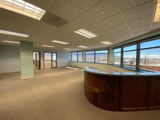


Property Detail
500 10Th St
R010978
SUBD: ALAMO BLOCKS REPLAT A BLK 29 LOT 1A BLOCK: 29
Financialbuilding
Otero
C-3
New Mexico
AH Areas with a 1% annual chance of shallow flooding, usually in the form of a pond, withan average depth ranging from 1 to 3 feet. These areas have a 26% chance of flooding over the life of a 30-year mortgage.
1a
2025
1.81 AC
2025
Las Cruces/Alamogordo
000100
Other Market Areas
32,430 SF
Alamogordo, NM
NEARBY LISTINGS FOR SALE OR LEASE
DEMOGRAPHICS near 500 10Th St
1 mile
3 mile
5 mile
2025 Total Population
5,793
27,471
32,324
2030 Population
5,904
27,590
32,540
Pop Growth 2025-2030
+ 1.92%
+ 0.43%
+ 0.67%
Average Age
40
40
40
2025 Total Households
2,582
11,832
13,854
HH Growth 2025-2030
+ 1.86%
+ 0.26%
+ 0.51%
Median Household Inc
$45,222
$51,143
$51,784
Avg Household Size
2.10
2.20
2.20
2025 Avg HH Vehicles
2.00
2.00
2.00
Median Home Value
$128,321
$174,150
$174,327
Median Year Built
1959
1976
1978
Nearby Places
Map Layers
Map Styles
 Street
 Aerial
Transit
 Traffic
 Biking
Places
Listings with unknown addresses are not visible on the map
- Restaurants
- Banks
- Shops
- Fitness
- Groceries
SALE & LEASE HISTORY
LISTING DATE
SALE/LEASE

Aug 19, 2021
For Lease
Nearby Properties
Address
Land Use
TOTAL SIZE
Lot Size
Zoning
Address
Land Use
TOTAL SIZE
Lot Size
Zoning
252,192 SF
21.50 AC
C-3
Address
Land Use
TOTAL SIZE
Lot Size
Zoning
5,378 SF
18.65 AC
C-3
Address
Land Use
TOTAL SIZE
Lot Size
Zoning
7,534 SF
66.27 AC
R-1
Address
Land Use
TOTAL SIZE
Lot Size
Zoning
21,306 SF
8.85 AC
R-1
Address
Land Use
TOTAL SIZE
Lot Size
Zoning
33.74 AC
R-1
Address
Land Use
TOTAL SIZE
Lot Size
Zoning
366,561 SF
16.31 AC
C-3
Address
Land Use
TOTAL SIZE
Lot Size
Zoning
76,539 SF
8.24 AC
R-1
Address
Land Use
TOTAL SIZE
Lot Size
Zoning
211,757 SF
4.86 AC
Address
Land Use
TOTAL SIZE
Lot Size
Zoning
22,893 SF
2.18 AC
C-3
Address
Land Use
TOTAL SIZE
Lot Size
Zoning
48,176 SF
2.35 AC
C-3
Address
Land Use
TOTAL SIZE
Lot Size
Zoning
56,121 SF
1.81 AC
C-3
Address
Land Use
TOTAL SIZE
Lot Size
Zoning
6,928 SF
30.66 AC
R-1
Address
Land Use
TOTAL SIZE
Lot Size
Zoning
102,439 SF
12.52 AC
R-2
Address
Land Use
TOTAL SIZE
Lot Size
Zoning
53,799 SF
3.97 AC
C-3
Address
Land Use
TOTAL SIZE
Lot Size
Zoning
42,104 SF
6.70 AC
C-3
Address
Land Use
TOTAL SIZE
Lot Size
Zoning
31,264 SF
4.75 AC
C-3
Address
Land Use
TOTAL SIZE
Lot Size
Zoning
28,510 SF
5.87 AC
C-3
Address
Land Use
TOTAL SIZE
Lot Size
Zoning
112,326 SF
11.14 AC
R-4
Address
Land Use
TOTAL SIZE
Lot Size
Zoning
39,856 SF
1.97 AC
C-3
Address
Land Use
TOTAL SIZE
Lot Size
Zoning
2,440 SF
22.25 AC
M-2
Address
Land Use
TOTAL SIZE
Lot Size
Zoning
34,589 SF
3.42 AC
C-3
Address
Land Use
TOTAL SIZE
Lot Size
Zoning
20,889 SF
3.12 AC
C-3
Address
Land Use
TOTAL SIZE
Lot Size
Zoning
40,607 SF
3.06 AC
M-2
Address
Land Use
TOTAL SIZE
Lot Size
Zoning
32,278 SF
8.39 AC
Address
Land Use
TOTAL SIZE
Lot Size
Zoning
45,123 SF
2.03 AC
C-3
Address
Land Use
TOTAL SIZE
Lot Size
Zoning
7,320 SF
5.74 AC
C-3
Address
Land Use
TOTAL SIZE
Lot Size
Zoning
54,880 SF
5.17 AC
C-3
Address
Land Use
TOTAL SIZE
Lot Size
Zoning
2,304 SF
4.19 AC
C-3
Address
Land Use
TOTAL SIZE
Lot Size
Zoning
46,761 SF
2.42 AC
C-3
The World's #1 Commercial Real Estate Marketplace
Connect with us
© 2026 CoStar Group
The information above has been obtained from sources believed reliable. While we do not doubt its accuracy we have not verified it and make no guarantee, warranty or representation about it. It is your responsibility to independently confirm its accuracy and completeness. Any projections, opinions, assumptions, or estimates used are for example only and do not represent the current or future performance of the property. The value of this transaction to you depends on tax and other factors which should be evaluated by your tax, financial, and legal advisors. You and your advisors should conduct a careful, independent investigation of the property to determine to your satisfaction the suitability of the property for your needs.