Property Record
5020 Chaparral Ct, Boulder, CO 80301
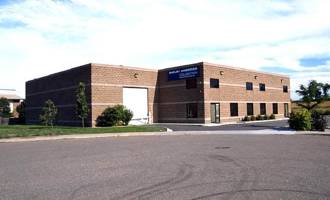

Property Detail
5020 Chaparral Ct
1463112-12-003
LOT 3 TRACT E FIRST REPLAT
Warehouse
Boulder
MF
Colorado
B and X Area of moderate flood hazard, usually the area between the limits of the 100-year and 500-year floods.
3
2024
0.61 AC
2025
Boulder
012705
Denver
10,054 SF
Boulder, CO
NEARBY LISTINGS FOR SALE OR LEASE
DEMOGRAPHICS near 5020 Chaparral Ct
1 mile
3 mile
5 mile
2024 Total Population
6,720
17,488
76,600
2029 Population
6,630
17,307
76,574
Pop Growth 2024-2029
(1.34%)
(1.03%)
(0.03%)
Average Age
42
44
41
2024 Total Households
3,413
7,573
33,570
HH Growth 2024-2029
(1.52%)
(1.20%)
+ 0.01%
Median Household Inc
$98,291
$113,951
$94,188
Avg Household Size
1.90
2.20
2.20
2024 Avg HH Vehicles
2.00
2.00
2.00
Median Home Value
$776,896
$841,690
$926,718
Median Year Built
1984
1982
1982
Nearby Places
Map Layers
Map Styles
 Street
 Aerial
Transit
 Traffic
 Biking
Places
Listings with unknown addresses are not visible on the map
- Restaurants
- Banks
- Shops
- Fitness
- Groceries
PUBLIC TRANSPORTATION
AIRPORT
Denver International
Drive
Walk
Distance
Denver International
56 min
44.4 mi
Nearby Properties
Address
Land Use
TOTAL SIZE
Lot Size
Zoning
Address
Land Use
TOTAL SIZE
Lot Size
Zoning
17.51 AC
Address
Land Use
TOTAL SIZE
Lot Size
Zoning
155.96 AC
Address
Land Use
TOTAL SIZE
Lot Size
Zoning
141.82 AC
A
Address
Land Use
TOTAL SIZE
Lot Size
Zoning
2,696,002 SF
344.44 AC
Address
Land Use
TOTAL SIZE
Lot Size
Zoning
329,080 SF
16.41 AC
Address
Land Use
TOTAL SIZE
Lot Size
Zoning
97.48 AC
A
Address
Land Use
TOTAL SIZE
Lot Size
Zoning
558,472 SF
23.18 AC
Address
Land Use
TOTAL SIZE
Lot Size
Zoning
228.08 AC
A
Address
Land Use
TOTAL SIZE
Lot Size
Zoning
158.31 AC
Address
Land Use
TOTAL SIZE
Lot Size
Zoning
38.79 AC
RR
Address
Land Use
TOTAL SIZE
Lot Size
Zoning
147.13 AC
A
Address
Land Use
TOTAL SIZE
Lot Size
Zoning
48.98 AC
A
Address
Land Use
TOTAL SIZE
Lot Size
Zoning
161.08 AC
A
Address
Land Use
TOTAL SIZE
Lot Size
Zoning
158.19 AC
A
Address
Land Use
TOTAL SIZE
Lot Size
Zoning
159.19 AC
A
Address
Land Use
TOTAL SIZE
Lot Size
Zoning
42.88 AC
RR
Address
Land Use
TOTAL SIZE
Lot Size
Zoning
161,711 SF
20.40 AC
MH
Address
Land Use
TOTAL SIZE
Lot Size
Zoning
107.31 AC
A
Address
Land Use
TOTAL SIZE
Lot Size
Zoning
27.92 AC
RR
Address
Land Use
TOTAL SIZE
Lot Size
Zoning
223,669 SF
14.27 AC
Address
Land Use
TOTAL SIZE
Lot Size
Zoning
304,116 SF
23.66 AC
MF
Address
Land Use
TOTAL SIZE
Lot Size
Zoning
103,400 SF
21.82 AC
Address
Land Use
TOTAL SIZE
Lot Size
Zoning
165.77 AC
A
Address
Land Use
TOTAL SIZE
Lot Size
Zoning
86.70 AC
A
Address
Land Use
TOTAL SIZE
Lot Size
Zoning
267.15 AC
RR
Address
Land Use
TOTAL SIZE
Lot Size
Zoning
33.28 AC
A
Address
Land Use
TOTAL SIZE
Lot Size
Zoning
150.10 AC
A
Address
Land Use
TOTAL SIZE
Lot Size
Zoning
1,072,030 SF
119.89 AC
Address
Land Use
TOTAL SIZE
Lot Size
Zoning
83.95 AC
A
Address
Land Use
TOTAL SIZE
Lot Size
Zoning
84.07 AC
A
The World's #1 Commercial Real Estate Marketplace
Connect with us
© 2026 CoStar Group
The information above has been obtained from sources believed reliable. While we do not doubt its accuracy we have not verified it and make no guarantee, warranty or representation about it. It is your responsibility to independently confirm its accuracy and completeness. Any projections, opinions, assumptions, or estimates used are for example only and do not represent the current or future performance of the property. The value of this transaction to you depends on tax and other factors which should be evaluated by your tax, financial, and legal advisors. You and your advisors should conduct a careful, independent investigation of the property to determine to your satisfaction the suitability of the property for your needs.