Property Record
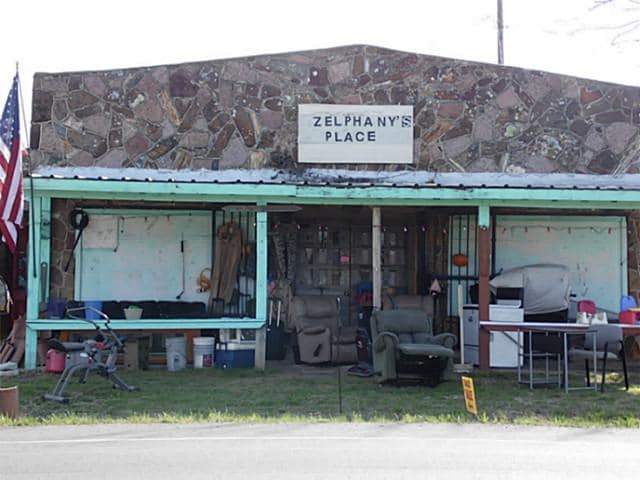
5050 E Highway 199, Springtown, TX 76082

Property Detail
5050 E Highway 199
R000052342
ACRES: 1.382 ABST: 1280, DRIVING NAILS GUNSMITHING
Commercialnec
Parker
B and X Area of moderate flood hazard, usually the area between the limits of the 100-year and 500-year floods.
Texas
2024
1.38 AC
2025
Parker County
140408
Dallas/Ft Worth
1,975 SF
Dallas-Fort Worth-Arlington, TX
NEARBY LISTINGS FOR SALE OR LEASE
-
-
View all Springtown listings for sale on LoopNet.com
DEMOGRAPHICS near 5050 E Highway 199
1 mile
3 mile
5 mile
2025 Total Population
1,423
13,950
41,130
2030 Population
1,667
16,298
46,863
Pop Growth 2025-2030
+ 17.15%
+ 16.83%
+ 13.94%
Average Age
40
39
40
2025 Total Households
503
4,840
14,920
HH Growth 2025-2030
+ 16.30%
+ 16.10%
+ 13.34%
Median Household Inc
$92,929
$87,997
$86,790
Avg Household Size
2.70
2.80
2.70
2025 Avg HH Vehicles
3.00
2.00
2.00
Median Home Value
$344,852
$266,463
$318,785
Median Year Built
2000
1999
1996
Nearby Places
Map Layers
Map Styles
 Street
 Aerial
Transit
 Traffic
 Biking
Places
Listings with unknown addresses are not visible on the map
- Restaurants
- Banks
- Shops
- Fitness
- Groceries
SALE & LEASE HISTORY
LISTING DATE
SALE/LEASE

Oct 13, 2017
For Sale
May 30, 2018
For Sale
Nearby Properties
Address
Land Use
TOTAL SIZE
Lot Size
Zoning
Address
Land Use
TOTAL SIZE
Lot Size
Zoning
62,068 SF
18.93 AC
Address
Land Use
TOTAL SIZE
Lot Size
Zoning
69,227 SF
19.02 AC
Address
Land Use
TOTAL SIZE
Lot Size
Zoning
15,520 SF
5.46 AC
Address
Land Use
TOTAL SIZE
Lot Size
Zoning
585 SF
7.25 AC
Address
Land Use
TOTAL SIZE
Lot Size
Zoning
13,281 SF
1 AC
Address
Land Use
TOTAL SIZE
Lot Size
Zoning
19,632 SF
10.05 AC
Address
Land Use
TOTAL SIZE
Lot Size
Zoning
16,200 SF
9.28 AC
Address
Land Use
TOTAL SIZE
Lot Size
Zoning
18,491 SF
6.60 AC
Address
Land Use
TOTAL SIZE
Lot Size
Zoning
25,564 SF
3.59 AC
Address
Land Use
TOTAL SIZE
Lot Size
Zoning
52,648 SF
4.08 AC
Address
Land Use
TOTAL SIZE
Lot Size
Zoning
5,000 SF
7.73 AC
Address
Land Use
TOTAL SIZE
Lot Size
Zoning
900 SF
11.21 AC
Address
Land Use
TOTAL SIZE
Lot Size
Zoning
1,820 SF
7.79 AC
Address
Land Use
TOTAL SIZE
Lot Size
Zoning
6,378 SF
9.16 AC
Address
Land Use
TOTAL SIZE
Lot Size
Zoning
25,200 SF
10.16 AC
Address
Land Use
TOTAL SIZE
Lot Size
Zoning
5,828 SF
6.80 AC
Address
Land Use
TOTAL SIZE
Lot Size
Zoning
5,954 SF
3.43 AC
Address
Land Use
TOTAL SIZE
Lot Size
Zoning
42,240 SF
4.27 AC
Address
Land Use
TOTAL SIZE
Lot Size
Zoning
7,319 SF
1.48 AC
Address
Land Use
TOTAL SIZE
Lot Size
Zoning
10,857 SF
1.49 AC
Address
Land Use
TOTAL SIZE
Lot Size
Zoning
5,520 SF
3.08 AC
Address
Land Use
TOTAL SIZE
Lot Size
Zoning
42,245 SF
6.68 AC
Address
Land Use
TOTAL SIZE
Lot Size
Zoning
9,100 SF
1.32 AC
Address
Land Use
TOTAL SIZE
Lot Size
Zoning
2,790 SF
38.05 AC
Address
Land Use
TOTAL SIZE
Lot Size
Zoning
16,800 SF
3.35 AC
Address
Land Use
TOTAL SIZE
Lot Size
Zoning
10,440 SF
0.86 AC
Address
Land Use
TOTAL SIZE
Lot Size
Zoning
4.18 AC
Address
Land Use
TOTAL SIZE
Lot Size
Zoning
16,575 SF
1.38 AC
Address
Land Use
TOTAL SIZE
Lot Size
Zoning
53,494 SF
6.28 AC
Address
Land Use
TOTAL SIZE
Lot Size
Zoning
5,077 SF
3.74 AC
The World's #1 Commercial Real Estate Marketplace
Connect with us
© 2026 CoStar Group
The information above has been obtained from sources believed reliable. While we do not doubt its accuracy we have not verified it and make no guarantee, warranty or representation about it. It is your responsibility to independently confirm its accuracy and completeness. Any projections, opinions, assumptions, or estimates used are for example only and do not represent the current or future performance of the property. The value of this transaction to you depends on tax and other factors which should be evaluated by your tax, financial, and legal advisors. You and your advisors should conduct a careful, independent investigation of the property to determine to your satisfaction the suitability of the property for your needs.