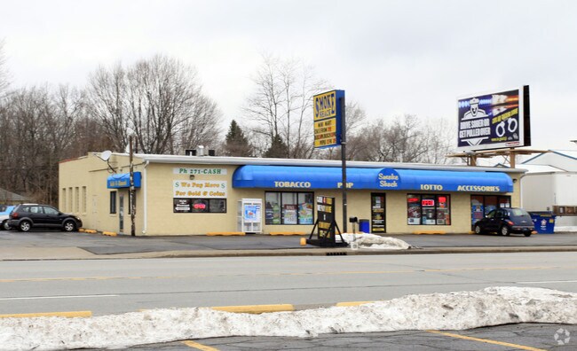
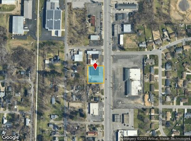
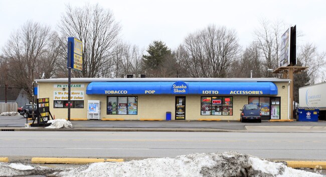
Property Record
50649 Indiana State Route 933, South Bend, IN 46637
NEARBY LISTINGS FOR SALE OR LEASE
Property Detail
50649 Indiana State Route 933
South Bend-Mishawaka, IN-MI
Mich Inda
71-03-12-307-014.000-003
S 1/2 LOT 25 & ALL LOTS 26, 27, 28 & N 1/2 LOT 29 MICH INDA 21/22 CON W/ 002-1082-3779 PER ASSESSOR IC 6-1.1-5-16
Storebuilding
St Joseph
X
Indiana
18141C0070D
25,26
2023
0.54 AC
2024
Outlying St Joseph County
011308
South Bend/Mishawaka
5,760 SF
DEMOGRAPHICS near 50649 Indiana State Route 933
1 Mile
3 Mile
5 Mile
2024 Total Population
3,070
28,641
91,406
2029 Population
3,029
28,240
90,862
Pop Growth 2024-2029
(1.34%)
(1.40%)
(0.60%)
Average Age
43
42
39
2024 Total Households
1,196
11,887
34,778
HH Growth 2024-2029
(1.42%)
(1.44%)
(0.65%)
Median Household Inc
$67,083
$80,782
$65,577
Avg Household Size
2.30
2.30
2.30
2024 Avg HH Vehicles
2.00
2.00
2.00
Median Home Value
$152,650
$185,099
$177,536
Median Year Built
1958
1976
1973
Nearby Places
Map Layers
Map Styles
 Street
 Aerial
- Restaurants
- Banks
- Shops
- Fitness
- Groceries
PUBLIC TRANSPORTATION
AIRPORT
South Bend International
DRIVE
WALK
Distance
South Bend International
27 min
10.4 mi
Freight Ports
Port Milwaukee
DRIVE
WALK
Distance
Port Milwaukee
217 min
181.4 mi
Nearby Properties
Address
Land Use
TOTAL SIZE
Lot Size
Zoning
Address
Land Use
TOTAL SIZE
Lot Size
Zoning
799,664 SF
0.01 AC
Address
Land Use
TOTAL SIZE
Lot Size
Zoning
356,520 SF
28.07 AC
Address
Land Use
TOTAL SIZE
Lot Size
Zoning
157,702 SF
44 SF
Address
Land Use
TOTAL SIZE
Lot Size
Zoning
114,844 SF
4.17 AC
Address
Land Use
TOTAL SIZE
Lot Size
Zoning
63,780 SF
44 SF
Address
Land Use
TOTAL SIZE
Lot Size
Zoning
214,657 SF
131 SF
Address
Land Use
TOTAL SIZE
Lot Size
Zoning
203,750 SF
22.36 AC
Address
Land Use
TOTAL SIZE
Lot Size
Zoning
63,374 SF
1.99 AC
Address
Land Use
TOTAL SIZE
Lot Size
Zoning
33,936 SF
1.84 AC
GB
Address
Land Use
TOTAL SIZE
Lot Size
Zoning
70,170 SF
4.01 AC
Address
Land Use
TOTAL SIZE
Lot Size
Zoning
62,968 SF
2.66 AC
Address
Land Use
TOTAL SIZE
Lot Size
Zoning
164,768 SF
24.57 AC
GB
Address
Land Use
TOTAL SIZE
Lot Size
Zoning
215,252 SF
18.33 AC
Address
Land Use
TOTAL SIZE
Lot Size
Zoning
80,666 SF
3.41 AC
Address
Land Use
TOTAL SIZE
Lot Size
Zoning
41,512 SF
1.37 AC
Address
Land Use
TOTAL SIZE
Lot Size
Zoning
40,244 SF
2.15 AC
Address
Land Use
TOTAL SIZE
Lot Size
Zoning
135,152 SF
8.76 AC
GB
Address
Land Use
TOTAL SIZE
Lot Size
Zoning
35,651 SF
87 SF
Address
Land Use
TOTAL SIZE
Lot Size
Zoning
20,553 SF
44 SF
Address
Land Use
TOTAL SIZE
Lot Size
Zoning
58,646 SF
1 AC
Address
Land Use
TOTAL SIZE
Lot Size
Zoning
93,452 SF
44 SF
Address
Land Use
TOTAL SIZE
Lot Size
Zoning
72,906 SF
2.73 AC
Address
Land Use
TOTAL SIZE
Lot Size
Zoning
55,137 SF
1.90 AC
Address
Land Use
TOTAL SIZE
Lot Size
Zoning
300,000 SF
65.30 AC
I
Address
Land Use
TOTAL SIZE
Lot Size
Zoning
40,373 SF
5.23 AC
Address
Land Use
TOTAL SIZE
Lot Size
Zoning
46,764 SF
0.92 AC
Address
Land Use
TOTAL SIZE
Lot Size
Zoning
26,140 SF
131 SF
Address
Land Use
TOTAL SIZE
Lot Size
Zoning
49,914 SF
6.18 AC
GB
Address
Land Use
TOTAL SIZE
Lot Size
Zoning
52,528 SF
2.41 AC
Address
Land Use
TOTAL SIZE
Lot Size
Zoning
42,210 SF
15.08 AC
The World's #1 Commercial Real Estate Marketplace
Connect with us
© 2025 CoStar Group
The information above has been obtained from sources believed reliable. While we do not doubt its accuracy we have not verified it and make no guarantee, warranty or representation about it. It is your responsibility to independently confirm its accuracy and completeness. Any projections, opinions, assumptions, or estimates used are for example only and do not represent the current or future performance of the property. The value of this transaction to you depends on tax and other factors which should be evaluated by your tax, financial, and legal advisors. You and your advisors should conduct a careful, independent investigation of the property to determine to your satisfaction the suitability of the property for your needs.