Property Record
River Rd, Naperville, IL 60536
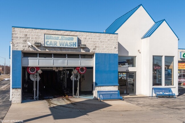

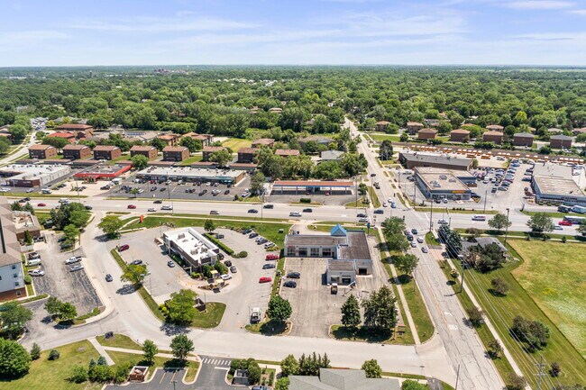
Property Detail
River Rd
07-14-101-009
AMOCO SUB ALL
Commercialnec
DUPAGE
C
Illinois
B and X Area of moderate flood hazard, usually the area between the limits of the 100-year and 500-year floods.
1
2024
0.88 AC
2024
Western East/West Corr
890602
Chicago
9,443 SF
Chicago-Naperville-Elgin, IL-IN
NEARBY LISTINGS FOR SALE OR LEASE
DEMOGRAPHICS near River Rd
1 mile
3 mile
5 mile
2024 Total Population
13,135
86,665
217,150
2029 Population
13,420
88,465
220,215
Pop Growth 2024-2029
+ 2.17%
+ 2.08%
+ 1.41%
Average Age
40
40
40
2024 Total Households
5,269
33,781
80,972
HH Growth 2024-2029
+ 2.30%
+ 2.17%
+ 1.47%
Median Household Inc
$100,947
$117,902
$122,320
Avg Household Size
2.40
2.50
2.60
2024 Avg HH Vehicles
2.00
2.00
2.00
Median Home Value
$450,476
$452,308
$445,506
Median Year Built
1983
1986
1987
Nearby Places
Map Layers
Map Styles
 Street
 Aerial
Transit
 Traffic
 Biking
Places
Listings with unknown addresses are not visible on the map
- Restaurants
- Banks
- Shops
- Fitness
- Groceries
PUBLIC TRANSPORTATION
COMMUTER RAIL
Route 59 Station (Burlington Northern-Santa Fe Railway Line - Northeast Illinois Regional Commuter Railroad (Metra))
Drive
Walk
Distance
Route 59 Station (Burlington Northern-Santa Fe Railway Line - Northeast Illinois Regional Commuter Railroad (Metra))
5 min
2.0 mi
Naperville Station (Burlington Northern-Santa Fe Railway Line - Northeast Illinois Regional Commuter Railroad (Metra))
Drive
Walk
Distance
Naperville Station (Burlington Northern-Santa Fe Railway Line - Northeast Illinois Regional Commuter Railroad (Metra))
6 min
2.3 mi
AIRPORT
Chicago Midway International
Drive
Walk
Distance
Chicago Midway International
45 min
27.9 mi
Chicago O'Hare International
Drive
Walk
Distance
Chicago O'Hare International
45 min
28.7 mi
SALE & LEASE HISTORY
LISTING DATE
SALE/LEASE

May 22, 2024
For Sale
Mar 10, 2020
For Lease
Jun 30, 2022
For Sale
Nearby Properties
Address
Land Use
TOTAL SIZE
Lot Size
Zoning
Address
Land Use
TOTAL SIZE
Lot Size
Zoning
916,143 SF
32.66 AC
Address
Land Use
TOTAL SIZE
Lot Size
Zoning
29.20 AC
C
Address
Land Use
TOTAL SIZE
Lot Size
Zoning
20.60 AC
Address
Land Use
TOTAL SIZE
Lot Size
Zoning
47.26 AC
Address
Land Use
TOTAL SIZE
Lot Size
Zoning
Address
Land Use
TOTAL SIZE
Lot Size
Zoning
17.59 AC
Address
Land Use
TOTAL SIZE
Lot Size
Zoning
31.66 AC
C
Address
Land Use
TOTAL SIZE
Lot Size
Zoning
19.92 AC
C
Address
Land Use
TOTAL SIZE
Lot Size
Zoning
17.70 AC
Address
Land Use
TOTAL SIZE
Lot Size
Zoning
Address
Land Use
TOTAL SIZE
Lot Size
Zoning
Address
Land Use
TOTAL SIZE
Lot Size
Zoning
797,399 SF
52.38 AC
C
Address
Land Use
TOTAL SIZE
Lot Size
Zoning
829,087 SF
35.83 AC
C
Address
Land Use
TOTAL SIZE
Lot Size
Zoning
272,400 SF
20.94 AC
C
Address
Land Use
TOTAL SIZE
Lot Size
Zoning
315,328 SF
5.06 AC
Address
Land Use
TOTAL SIZE
Lot Size
Zoning
25 AC
M
Address
Land Use
TOTAL SIZE
Lot Size
Zoning
20.97 AC
R
Address
Land Use
TOTAL SIZE
Lot Size
Zoning
15.33 AC
I
Address
Land Use
TOTAL SIZE
Lot Size
Zoning
5.43 AC
Address
Land Use
TOTAL SIZE
Lot Size
Zoning
266,118 SF
21.65 AC
C
Address
Land Use
TOTAL SIZE
Lot Size
Zoning
17.84 AC
M
Address
Land Use
TOTAL SIZE
Lot Size
Zoning
1,059,897 SF
122.10 AC
C
Address
Land Use
TOTAL SIZE
Lot Size
Zoning
721,600 SF
34.74 AC
I
Address
Land Use
TOTAL SIZE
Lot Size
Zoning
16.15 AC
M
Address
Land Use
TOTAL SIZE
Lot Size
Zoning
166,222 SF
8.81 AC
C
Address
Land Use
TOTAL SIZE
Lot Size
Zoning
15.61 AC
M
Address
Land Use
TOTAL SIZE
Lot Size
Zoning
31.08 AC
Address
Land Use
TOTAL SIZE
Lot Size
Zoning
Address
Land Use
TOTAL SIZE
Lot Size
Zoning
239,418 SF
21.27 AC
C
Address
Land Use
TOTAL SIZE
Lot Size
Zoning
505,720 SF
27.67 AC
The World's #1 Commercial Real Estate Marketplace
Connect with us
© 2026 CoStar Group
The information above has been obtained from sources believed reliable. While we do not doubt its accuracy we have not verified it and make no guarantee, warranty or representation about it. It is your responsibility to independently confirm its accuracy and completeness. Any projections, opinions, assumptions, or estimates used are for example only and do not represent the current or future performance of the property. The value of this transaction to you depends on tax and other factors which should be evaluated by your tax, financial, and legal advisors. You and your advisors should conduct a careful, independent investigation of the property to determine to your satisfaction the suitability of the property for your needs.