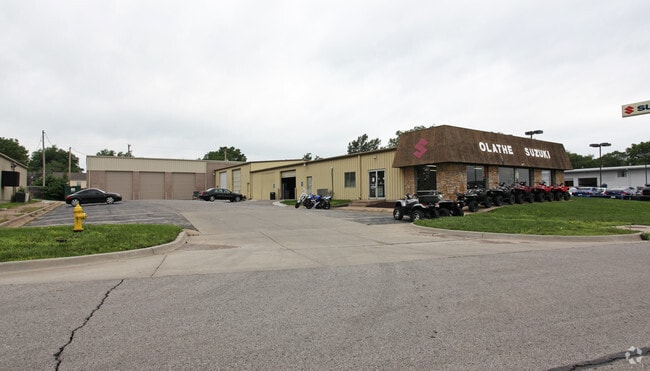
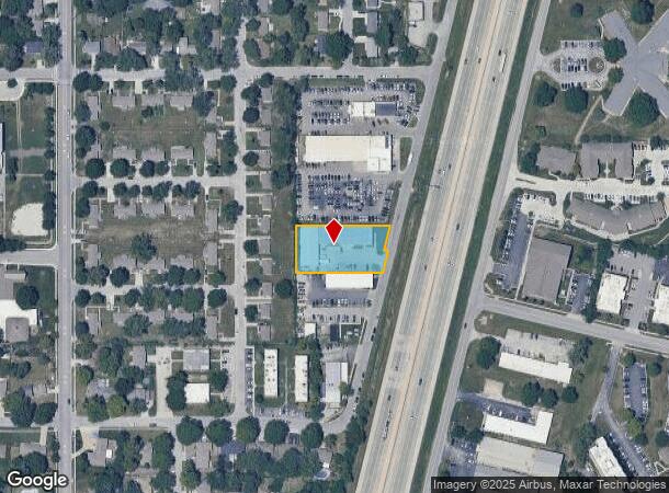
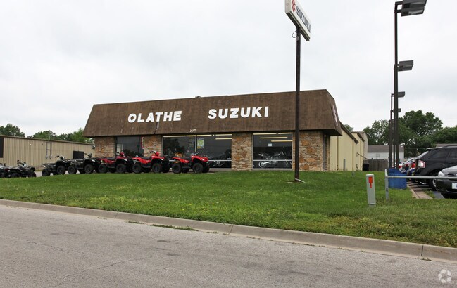
Property Record
509 S Fir St, Olathe, KS 66061
NEARBY LISTINGS FOR SALE OR LEASE
Property Detail
509 S Fir St
Kansas City, MO-KS
Ridgeview Addition To The
DP63000004-000A1
RIDGEVIEW ADDITION TO THE CITY OF OLATHE KANSAS BLOCKS 1 TO 4 INCLUSIVE N 65.1 LT A BLK 4 & RIDGEVIEW ADDITION NO. 3 S 69.9 LT H OLC 2639 39A
Vehiclerentalsvehiclesales
Johnson
X
Kansas
20091C0079G
a
2024
0.75 AC
2024
Olathe
053556
Kansas City
13,000 SF
DEMOGRAPHICS near 509 S Fir St
1 Mile
3 Mile
5 Mile
2024 Total Population
11,733
99,846
173,348
2029 Population
12,101
103,510
180,616
Pop Growth 2024-2029
+ 3.14%
+ 3.67%
+ 4.19%
Average Age
36
37
38
2024 Total Households
4,382
35,775
62,704
HH Growth 2024-2029
+ 3.19%
+ 3.84%
+ 4.28%
Median Household Inc
$55,483
$88,719
$101,581
Avg Household Size
2.40
2.70
2.70
2024 Avg HH Vehicles
2.00
2.00
2.00
Median Home Value
$208,871
$265,641
$322,331
Median Year Built
1971
1988
1994
Nearby Places
Map Layers
Map Styles
 Street
 Aerial
- Restaurants
- Banks
- Shops
- Fitness
- Groceries
PUBLIC TRANSPORTATION
AIRPORT
Kansas City International
DRIVE
WALK
Distance
Kansas City International
49 min
38.1 mi
Freight Ports
Tulsa Port Of Catoosa
DRIVE
WALK
Distance
Tulsa Port Of Catoosa
256 min
225.6 mi
Nearby Properties
Address
Land Use
TOTAL SIZE
Lot Size
Zoning
Address
Land Use
TOTAL SIZE
Lot Size
Zoning
401,604 SF
28.35 AC
CP-O
Address
Land Use
TOTAL SIZE
Lot Size
Zoning
307,761 SF
6.59 AC
C-2
Address
Land Use
TOTAL SIZE
Lot Size
Zoning
482,713 SF
77.78 AC
AG
Address
Land Use
TOTAL SIZE
Lot Size
Zoning
162,499 SF
38.74 AC
R-1
Address
Land Use
TOTAL SIZE
Lot Size
Zoning
512,643 SF
75.55 AC
AG
Address
Land Use
TOTAL SIZE
Lot Size
Zoning
456,742 SF
27.31 AC
R-1
Address
Land Use
TOTAL SIZE
Lot Size
Zoning
97,340 SF
1.82 AC
C-2
Address
Land Use
TOTAL SIZE
Lot Size
Zoning
211,054 SF
77.48 AC
R-1
Address
Land Use
TOTAL SIZE
Lot Size
Zoning
88,459 SF
15.13 AC
R-1
Address
Land Use
TOTAL SIZE
Lot Size
Zoning
130,576 SF
15.20 AC
RP-4
Address
Land Use
TOTAL SIZE
Lot Size
Zoning
323,377 SF
15.55 AC
R-1
Address
Land Use
TOTAL SIZE
Lot Size
Zoning
211,785 SF
35.56 AC
RP-3
Address
Land Use
TOTAL SIZE
Lot Size
Zoning
19,460 SF
9.12 AC
R-1
Address
Land Use
TOTAL SIZE
Lot Size
Zoning
66,664 SF
2.94 AC
C-2
Address
Land Use
TOTAL SIZE
Lot Size
Zoning
202,726 SF
9.37 AC
R-1
Address
Land Use
TOTAL SIZE
Lot Size
Zoning
40,647 SF
7.40 AC
R-4
Address
Land Use
TOTAL SIZE
Lot Size
Zoning
177,274 SF
2.69 AC
C-2
Address
Land Use
TOTAL SIZE
Lot Size
Zoning
251,981 SF
10.79 AC
R-5
Address
Land Use
TOTAL SIZE
Lot Size
Zoning
129,325 SF
4.50 AC
R-1
Address
Land Use
TOTAL SIZE
Lot Size
Zoning
137,955 SF
23.80 AC
R-1
Address
Land Use
TOTAL SIZE
Lot Size
Zoning
107,857 SF
10.94 AC
C-2
Address
Land Use
TOTAL SIZE
Lot Size
Zoning
137,122 SF
7.68 AC
C-1
Address
Land Use
TOTAL SIZE
Lot Size
Zoning
146,832 SF
30 AC
R-1
Address
Land Use
TOTAL SIZE
Lot Size
Zoning
53,359 SF
41.55 AC
R-1
Address
Land Use
TOTAL SIZE
Lot Size
Zoning
150,122 SF
17.48 AC
R-1
Address
Land Use
TOTAL SIZE
Lot Size
Zoning
934,106 SF
34.09 AC
BP
Address
Land Use
TOTAL SIZE
Lot Size
Zoning
157,344 SF
12.69 AC
R-1
Address
Land Use
TOTAL SIZE
Lot Size
Zoning
188,944 SF
31.48 AC
R-1
Address
Land Use
TOTAL SIZE
Lot Size
Zoning
44,486 SF
2.70 AC
C-2
Address
Land Use
TOTAL SIZE
Lot Size
Zoning
61,479 SF
8.14 AC
C-2
The World's #1 Commercial Real Estate Marketplace
Connect with us
© 2025 CoStar Group
The information above has been obtained from sources believed reliable. While we do not doubt its accuracy we have not verified it and make no guarantee, warranty or representation about it. It is your responsibility to independently confirm its accuracy and completeness. Any projections, opinions, assumptions, or estimates used are for example only and do not represent the current or future performance of the property. The value of this transaction to you depends on tax and other factors which should be evaluated by your tax, financial, and legal advisors. You and your advisors should conduct a careful, independent investigation of the property to determine to your satisfaction the suitability of the property for your needs.