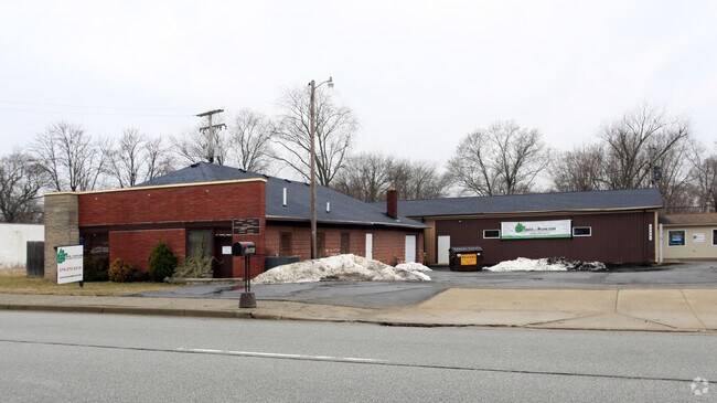
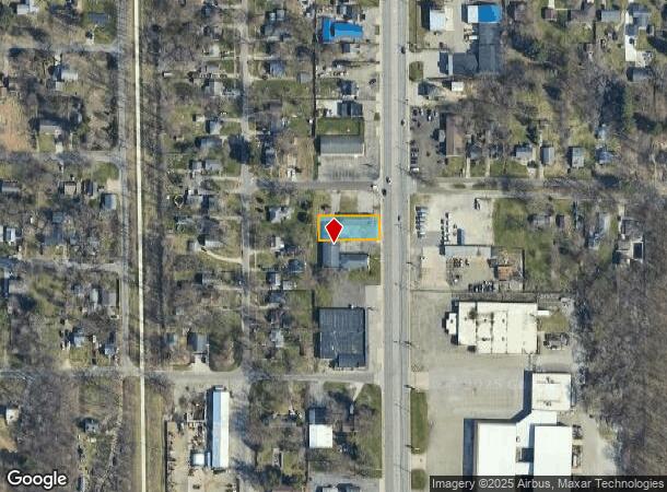
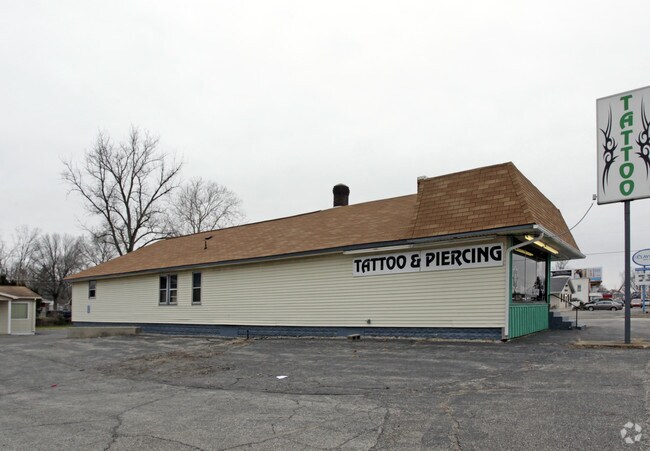
Property Record
50941 Indiana State Route 933, South Bend, IN 46637
NEARBY LISTINGS FOR SALE OR LEASE
Property Detail
50941 Indiana State Route 933
South Bend-Mishawaka, IN-MI
Dreamwold Hts 1St
71-03-12-357-011.000-003
LOT 8 & 14 S END LOT 9 DREAMWOLD HTS 1ST ALSO 7 VAC ALLEY W ADJ
Storebuilding
St Joseph
X
Indiana
18141C0070D
8,9
2023
0.24 AC
2024
Outlying St Joseph County
011303
South Bend/Mishawaka
4,648 SF
DEMOGRAPHICS near 50941 Indiana State Route 933
1 Mile
3 Mile
5 Mile
2024 Total Population
3,902
30,426
98,094
2029 Population
3,857
30,072
97,776
Pop Growth 2024-2029
(1.15%)
(1.16%)
(0.32%)
Average Age
42
42
38
2024 Total Households
1,568
12,723
37,675
HH Growth 2024-2029
(1.21%)
(1.19%)
(0.37%)
Median Household Inc
$76,635
$78,537
$63,251
Avg Household Size
2.40
2.30
2.30
2024 Avg HH Vehicles
2.00
2.00
2.00
Median Home Value
$158,465
$185,861
$177,280
Median Year Built
1964
1976
1973
Nearby Places
Map Layers
Map Styles
 Street
 Aerial
- Restaurants
- Banks
- Shops
- Fitness
- Groceries
PUBLIC TRANSPORTATION
AIRPORT
South Bend International
DRIVE
WALK
Distance
South Bend International
12 min
6.4 mi
Freight Ports
Port of Baltimore
DRIVE
WALK
Distance
Port of Baltimore
1 min
535.2 mi
SALE & LEASE HISTORY
LISTING DATE
SALE/LEASE

Aug 12, 2025
For Lease
Aug 07, 2017
For Sale
Nearby Properties
Address
Land Use
TOTAL SIZE
Lot Size
Zoning
Address
Land Use
TOTAL SIZE
Lot Size
Zoning
151,377 SF
0.01 AC
Address
Land Use
TOTAL SIZE
Lot Size
Zoning
799,664 SF
0.01 AC
Address
Land Use
TOTAL SIZE
Lot Size
Zoning
356,520 SF
28.07 AC
Address
Land Use
TOTAL SIZE
Lot Size
Zoning
174,997 SF
0.70 AC
Address
Land Use
TOTAL SIZE
Lot Size
Zoning
157,702 SF
44 SF
Address
Land Use
TOTAL SIZE
Lot Size
Zoning
114,844 SF
4.17 AC
Address
Land Use
TOTAL SIZE
Lot Size
Zoning
63,780 SF
44 SF
Address
Land Use
TOTAL SIZE
Lot Size
Zoning
214,657 SF
131 SF
Address
Land Use
TOTAL SIZE
Lot Size
Zoning
203,750 SF
22.36 AC
Address
Land Use
TOTAL SIZE
Lot Size
Zoning
63,374 SF
1.99 AC
Address
Land Use
TOTAL SIZE
Lot Size
Zoning
33,936 SF
1.84 AC
GB
Address
Land Use
TOTAL SIZE
Lot Size
Zoning
70,170 SF
4.01 AC
Address
Land Use
TOTAL SIZE
Lot Size
Zoning
266,881 SF
26.20 AC
Address
Land Use
TOTAL SIZE
Lot Size
Zoning
62,968 SF
2.66 AC
Address
Land Use
TOTAL SIZE
Lot Size
Zoning
54,048 SF
2.11 AC
Address
Land Use
TOTAL SIZE
Lot Size
Zoning
164,768 SF
24.57 AC
GB
Address
Land Use
TOTAL SIZE
Lot Size
Zoning
215,252 SF
18.33 AC
Address
Land Use
TOTAL SIZE
Lot Size
Zoning
4,448 SF
174 SF
Address
Land Use
TOTAL SIZE
Lot Size
Zoning
80,666 SF
3.41 AC
Address
Land Use
TOTAL SIZE
Lot Size
Zoning
41,512 SF
1.37 AC
Address
Land Use
TOTAL SIZE
Lot Size
Zoning
40,244 SF
2.15 AC
Address
Land Use
TOTAL SIZE
Lot Size
Zoning
27,132 SF
174 SF
Address
Land Use
TOTAL SIZE
Lot Size
Zoning
135,152 SF
8.76 AC
GB
Address
Land Use
TOTAL SIZE
Lot Size
Zoning
35,651 SF
87 SF
Address
Land Use
TOTAL SIZE
Lot Size
Zoning
20,553 SF
44 SF
Address
Land Use
TOTAL SIZE
Lot Size
Zoning
58,646 SF
1 AC
Address
Land Use
TOTAL SIZE
Lot Size
Zoning
93,452 SF
44 SF
Address
Land Use
TOTAL SIZE
Lot Size
Zoning
72,906 SF
2.73 AC
Address
Land Use
TOTAL SIZE
Lot Size
Zoning
55,137 SF
1.90 AC
Address
Land Use
TOTAL SIZE
Lot Size
Zoning
112,728 SF
9.61 AC
The World's #1 Commercial Real Estate Marketplace
Connect with us
© 2025 CoStar Group
The information above has been obtained from sources believed reliable. While we do not doubt its accuracy we have not verified it and make no guarantee, warranty or representation about it. It is your responsibility to independently confirm its accuracy and completeness. Any projections, opinions, assumptions, or estimates used are for example only and do not represent the current or future performance of the property. The value of this transaction to you depends on tax and other factors which should be evaluated by your tax, financial, and legal advisors. You and your advisors should conduct a careful, independent investigation of the property to determine to your satisfaction the suitability of the property for your needs.