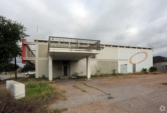
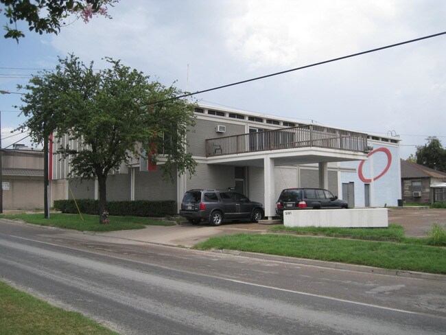
Property Record
5115 Navigation Blvd, Houston, TX 77011
Current Lease Availabilities
Property Detail
5115 Navigation Blvd
Houston-Pasadena-The Woodlands, TX
TRS 2 & 4 BLK 22 ENGEL
0131010220003
HARRIS
Commercialacreage
Texas
B and X Area of moderate flood hazard, usually the area between the limits of the 100-year and 500-year floods.
0.12 AC
2024
Gulf Freeway/Pasadena
2025
Houston
310500
NEARBY LISTINGS FOR SALE OR LEASE
DEMOGRAPHICS near 5115 Navigation Blvd
1 mile
3 mile
5 mile
2025 Total Population
12,122
153,793
404,347
2030 Population
13,109
165,638
437,013
Pop Growth 2025-2030
+ 8.14%
+ 7.70%
+ 8.08%
Average Age
40
37
37
2025 Total Households
4,737
54,800
163,032
HH Growth 2025-2030
+ 8.34%
+ 8.99%
+ 8.85%
Median Household Inc
$50,498
$57,257
$66,268
Avg Household Size
2.50
2.40
2.30
2025 Avg HH Vehicles
1.00
1.00
2.00
Median Home Value
$328,168
$288,604
$318,408
Median Year Built
1949
1963
1976
Nearby Places
Map Layers
Map Styles
 Street
 Aerial
Layers
 Traffic
 Biking
Places
Listings with unknown addresses are not visible on the map
- Restaurants
- Banks
- Shops
- Fitness
- Groceries
PUBLIC TRANSPORTATION
TRANSIT/SUBWAY
Altic / Howard Hughes Eb (METRORAIL GREEN LINE - Metropolitan Transit Authority of Harris County, METRORAIL PURPLE LINE - Metropolitan Transit Authority of Harris County)
Drive
Walk
Distance
Altic / Howard Hughes Eb (METRORAIL GREEN LINE - Metropolitan Transit Authority of Harris County, METRORAIL PURPLE LINE - Metropolitan Transit Authority of Harris County)
2 min
15 min
0.8 mi
Lockwood / Eastwood Eb (METRORAIL GREEN LINE - Metropolitan Transit Authority of Harris County, METRORAIL PURPLE LINE - Metropolitan Transit Authority of Harris County)
Drive
Walk
Distance
Lockwood / Eastwood Eb (METRORAIL GREEN LINE - Metropolitan Transit Authority of Harris County, METRORAIL PURPLE LINE - Metropolitan Transit Authority of Harris County)
1 min
16 min
0.8 mi
Lockwood / Eastwood Wb (METRORAIL GREEN LINE - Metropolitan Transit Authority of Harris County, METRORAIL PURPLE LINE - Metropolitan Transit Authority of Harris County)
Drive
Walk
Distance
Lockwood / Eastwood Wb (METRORAIL GREEN LINE - Metropolitan Transit Authority of Harris County, METRORAIL PURPLE LINE - Metropolitan Transit Authority of Harris County)
1 min
17 min
0.9 mi
COMMUTER RAIL
Houston (Sunset Limited - Amtrak)
Drive
Walk
Distance
Houston (Sunset Limited - Amtrak)
7 min
3.4 mi
AIRPORT
William P Hobby
Drive
Walk
Distance
William P Hobby
21 min
11.0 mi
George Bush Intcntl/Houston
Drive
Walk
Distance
George Bush Intcntl/Houston
28 min
19.8 mi
Freight Ports
Port of Houston
Drive
Walk
Distance
Port of Houston
13 min
5.9 mi
Nearby Properties
Address
Land Use
TOTAL SIZE
Lot Size
Zoning
Address
Land Use
TOTAL SIZE
Lot Size
Zoning
1,383,720 SF
1.47 AC
Address
Land Use
TOTAL SIZE
Lot Size
Zoning
1,101,686 SF
1.45 AC
Address
Land Use
TOTAL SIZE
Lot Size
Zoning
973,861 SF
1.18 AC
Address
Land Use
TOTAL SIZE
Lot Size
Zoning
899,279 SF
1.18 AC
Address
Land Use
TOTAL SIZE
Lot Size
Zoning
797,208 SF
1.46 AC
Address
Land Use
TOTAL SIZE
Lot Size
Zoning
1,916,394 SF
1.46 AC
Address
Land Use
TOTAL SIZE
Lot Size
Zoning
1,871,418 SF
1.44 AC
Address
Land Use
TOTAL SIZE
Lot Size
Zoning
1,091,726 SF
2.60 AC
Address
Land Use
TOTAL SIZE
Lot Size
Zoning
1,436,400 SF
1.44 AC
Address
Land Use
TOTAL SIZE
Lot Size
Zoning
1,321,033 SF
1.46 AC
Address
Land Use
TOTAL SIZE
Lot Size
Zoning
1,374,271 SF
1.44 AC
Address
Land Use
TOTAL SIZE
Lot Size
Zoning
515,025 SF
1.50 AC
Address
Land Use
TOTAL SIZE
Lot Size
Zoning
1,657,484 SF
1.44 AC
Address
Land Use
TOTAL SIZE
Lot Size
Zoning
1,311,133 SF
1.44 AC
Address
Land Use
TOTAL SIZE
Lot Size
Zoning
1,181,384 SF
1.47 AC
Address
Land Use
TOTAL SIZE
Lot Size
Zoning
1,162,204 SF
1.44 AC
Address
Land Use
TOTAL SIZE
Lot Size
Zoning
934,258 SF
1.45 AC
Address
Land Use
TOTAL SIZE
Lot Size
Zoning
1,103,424 SF
1.44 AC
Address
Land Use
TOTAL SIZE
Lot Size
Zoning
1,365,801 SF
1.44 AC
Address
Land Use
TOTAL SIZE
Lot Size
Zoning
1,017,783 SF
1.44 AC
Address
Land Use
TOTAL SIZE
Lot Size
Zoning
1,182,525 SF
1.11 AC
Address
Land Use
TOTAL SIZE
Lot Size
Zoning
612,078 SF
1.44 AC
Address
Land Use
TOTAL SIZE
Lot Size
Zoning
468,513 SF
0.86 AC
Address
Land Use
TOTAL SIZE
Lot Size
Zoning
1,392,720 SF
83.75 AC
Address
Land Use
TOTAL SIZE
Lot Size
Zoning
1,102,279 SF
1.44 AC
Address
Land Use
TOTAL SIZE
Lot Size
Zoning
396,910 SF
0.44 AC
Address
Land Use
TOTAL SIZE
Lot Size
Zoning
1,008,419 SF
1.44 AC
Address
Land Use
TOTAL SIZE
Lot Size
Zoning
871,650 SF
0.62 AC
Address
Land Use
TOTAL SIZE
Lot Size
Zoning
656,994 SF
4.01 AC
Address
Land Use
TOTAL SIZE
Lot Size
Zoning
596,700 SF
0.82 AC
The World's #1 Commercial Real Estate Marketplace
Connect with us
© 2026 CoStar Group
The information above has been obtained from sources believed reliable. While we do not doubt its accuracy we have not verified it and make no guarantee, warranty or representation about it. It is your responsibility to independently confirm its accuracy and completeness. Any projections, opinions, assumptions, or estimates used are for example only and do not represent the current or future performance of the property. The value of this transaction to you depends on tax and other factors which should be evaluated by your tax, financial, and legal advisors. You and your advisors should conduct a careful, independent investigation of the property to determine to your satisfaction the suitability of the property for your needs.