Property Record
5103 Portland Rd Ne, Salem, OR 97305
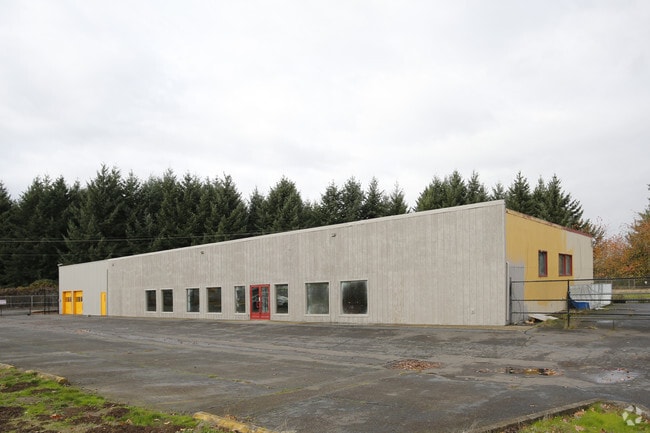

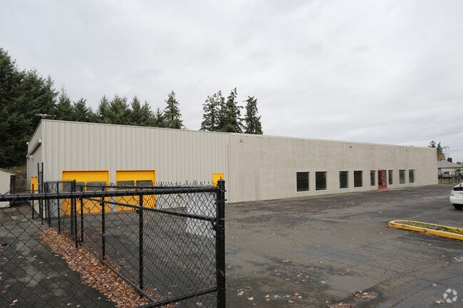

Property Detail
5103 Portland Rd Ne
522169
ACRES 1.25
Officebuilding
Marion
CG
Oregon
B and X Area of moderate flood hazard, usually the area between the limits of the 100-year and 500-year floods.
1.25 AC
2024
Marion County
2025
Portland
002502
Salem, OR
10,000 SF
NEARBY LISTINGS FOR SALE OR LEASE
DEMOGRAPHICS near 5103 Portland Rd Ne
1 mile
3 mile
5 mile
2025 Total Population
10,474
83,905
153,398
2030 Population
10,755
84,652
155,017
Pop Growth 2025-2030
+ 2.68%
+ 0.89%
+ 1.06%
Average Age
40
38
38
2025 Total Households
3,624
29,176
53,944
HH Growth 2025-2030
+ 2.84%
+ 1.01%
+ 1.13%
Median Household Inc
$73,046
$67,444
$67,277
Avg Household Size
2.80
2.80
2.70
2025 Avg HH Vehicles
2.00
2.00
2.00
Median Home Value
$390,552
$396,096
$391,193
Median Year Built
1990
1983
1978
Nearby Places
Map Layers
Map Styles
 Street
 Aerial
Transit
 Traffic
 Biking
Places
Listings with unknown addresses are not visible on the map
- Restaurants
- Banks
- Shops
- Fitness
- Groceries
PUBLIC TRANSPORTATION
COMMUTER RAIL
Drive
Walk
Distance
14 min
8.5 mi
Freight Ports
Port of Portland
Drive
Walk
Distance
Port of Portland
59 min
45.2 mi
SALE & LEASE HISTORY
LISTING DATE
SALE/LEASE

Jan 05, 2017
For Lease
Nearby Properties
Address
Land Use
TOTAL SIZE
Lot Size
Zoning
Address
Land Use
TOTAL SIZE
Lot Size
Zoning
58,868 SF
38.09 AC
P; RM
Address
Land Use
TOTAL SIZE
Lot Size
Zoning
532,684 SF
158.53 AC
PA
Address
Land Use
TOTAL SIZE
Lot Size
Zoning
94,577 SF
10.65 AC
PA
Address
Land Use
TOTAL SIZE
Lot Size
Zoning
236,632 SF
24.45 AC
CO
Address
Land Use
TOTAL SIZE
Lot Size
Zoning
318,068 SF
14.57 AC
RM2
Address
Land Use
TOTAL SIZE
Lot Size
Zoning
84,940 SF
16.75 AC
IBP
Address
Land Use
TOTAL SIZE
Lot Size
Zoning
164,539 SF
8.98 AC
CR; RM2
Address
Land Use
TOTAL SIZE
Lot Size
Zoning
253,189 SF
12.83 AC
RM2
Address
Land Use
TOTAL SIZE
Lot Size
Zoning
68,512 SF
9.09 AC
P
Address
Land Use
TOTAL SIZE
Lot Size
Zoning
29.36 AC
IG; CR
Address
Land Use
TOTAL SIZE
Lot Size
Zoning
161,418 SF
4.48 AC
MU
Address
Land Use
TOTAL SIZE
Lot Size
Zoning
74,496 SF
11.65 AC
IC
Address
Land Use
TOTAL SIZE
Lot Size
Zoning
134,440 SF
12.25 AC
IBP
Address
Land Use
TOTAL SIZE
Lot Size
Zoning
Address
Land Use
TOTAL SIZE
Lot Size
Zoning
42,077 SF
8.54 AC
P
Address
Land Use
TOTAL SIZE
Lot Size
Zoning
150,649 SF
3.67 AC
MU
Address
Land Use
TOTAL SIZE
Lot Size
Zoning
216,460 SF
CO
Address
Land Use
TOTAL SIZE
Lot Size
Zoning
171,349 SF
6.88 AC
RM
Address
Land Use
TOTAL SIZE
Lot Size
Zoning
101,921 SF
3.76 AC
MU
Address
Land Use
TOTAL SIZE
Lot Size
Zoning
74,549 SF
1.62 AC
IC
Address
Land Use
TOTAL SIZE
Lot Size
Zoning
112,380 SF
15.48 AC
P
Address
Land Use
TOTAL SIZE
Lot Size
Zoning
123,752 SF
10.14 AC
IBP
Address
Land Use
TOTAL SIZE
Lot Size
Zoning
143,992 SF
6.81 AC
RM2
Address
Land Use
TOTAL SIZE
Lot Size
Zoning
49,861 SF
8.60 AC
IC
Address
Land Use
TOTAL SIZE
Lot Size
Zoning
105,537 SF
5.86 AC
RS
Address
Land Use
TOTAL SIZE
Lot Size
Zoning
87,872 SF
7.99 AC
CR
Address
Land Use
TOTAL SIZE
Lot Size
Zoning
167,516 SF
7.42 AC
RM
Address
Land Use
TOTAL SIZE
Lot Size
Zoning
54,745 SF
5.32 AC
IBP
Address
Land Use
TOTAL SIZE
Lot Size
Zoning
136,937 SF
6.44 AC
RM2
Address
Land Use
TOTAL SIZE
Lot Size
Zoning
102,832 SF
4.93 AC
MU
The World's #1 Commercial Real Estate Marketplace
Connect with us
© 2026 CoStar Group
The information above has been obtained from sources believed reliable. While we do not doubt its accuracy we have not verified it and make no guarantee, warranty or representation about it. It is your responsibility to independently confirm its accuracy and completeness. Any projections, opinions, assumptions, or estimates used are for example only and do not represent the current or future performance of the property. The value of this transaction to you depends on tax and other factors which should be evaluated by your tax, financial, and legal advisors. You and your advisors should conduct a careful, independent investigation of the property to determine to your satisfaction the suitability of the property for your needs.