Property Record
5103 Robinhood Rd, Winston Salem, NC 27106
NEARBY LISTINGS FOR SALE OR LEASE
Property Detail
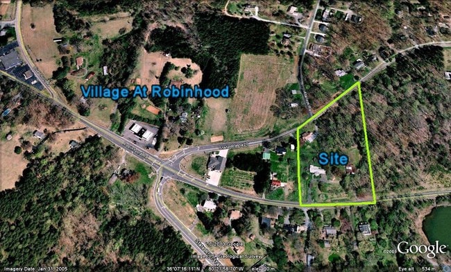
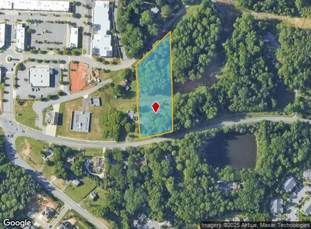
5103 Robinhood Rd
Winston-Salem, NC
Fleetwood Circle/Robinhood Rd
5896-75-0766
LO:030B BL:4637
Residentialacreage
Forsyth
X
North Carolina
3710589600J
30b
2024
3.08 AC
2025
Western Forsyth County
002606
Greensboro/Winston-Salem
DEMOGRAPHICS near 5103 Robinhood Rd
1 Mile
3 Mile
5 Mile
2024 Total Population
4,119
38,906
103,341
2029 Population
4,363
40,480
107,472
Pop Growth 2024-2029
+ 5.92%
+ 4.05%
+ 4.00%
Average Age
40
42
41
2024 Total Households
1,592
15,699
43,591
HH Growth 2024-2029
+ 5.97%
+ 4.02%
+ 4.01%
Median Household Inc
$116,948
$102,488
$77,426
Avg Household Size
2.60
2.40
2.30
2024 Avg HH Vehicles
2.00
2.00
2.00
Median Home Value
$383,715
$323,380
$281,836
Median Year Built
1998
1988
1983
Nearby Places
- Restaurants
- Banks
- Shops
- Fitness
- Groceries
PUBLIC TRANSPORTATION
AIRPORT
Piedmont Triad International
DRIVE
WALK
Distance
Piedmont Triad International
47 min
29.5 mi
Freight Ports
Virginia Port Authority - Richmond
DRIVE
WALK
Distance
Virginia Port Authority - Richmond
274 min
233.2 mi
Nearby Properties
Address
Land Use
TOTAL SIZE
Lot Size
Zoning
Address
Land Use
TOTAL SIZE
Lot Size
Zoning
124,972 SF
19.32 AC
MU-S
Address
Land Use
TOTAL SIZE
Lot Size
Zoning
128,592 SF
28.33 AC
GB-S
Address
Land Use
TOTAL SIZE
Lot Size
Zoning
95,995 SF
31.49 AC
RM12,RM18
Address
Land Use
TOTAL SIZE
Lot Size
Zoning
61,125 SF
8.66 AC
MU-S
Address
Land Use
TOTAL SIZE
Lot Size
Zoning
275,051 SF
32.47 AC
PB-S,RM18
Address
Land Use
TOTAL SIZE
Lot Size
Zoning
189,737 SF
20.53 AC
CD1-S
Address
Land Use
TOTAL SIZE
Lot Size
Zoning
139,775 SF
11.57 AC
HB,RS9
Address
Land Use
TOTAL SIZE
Lot Size
Zoning
115,352 SF
11.21 AC
RM8-S
Address
Land Use
TOTAL SIZE
Lot Size
Zoning
68,118 SF
12.74 AC
MU-S
Address
Land Use
TOTAL SIZE
Lot Size
Zoning
179,142 SF
42.52 AC
RS9
Address
Land Use
TOTAL SIZE
Lot Size
Zoning
120,118 SF
15.71 AC
RM18
Address
Land Use
TOTAL SIZE
Lot Size
Zoning
141,377 SF
37.07 AC
IP
Address
Land Use
TOTAL SIZE
Lot Size
Zoning
73,930 SF
18 AC
RM12-S
Address
Land Use
TOTAL SIZE
Lot Size
Zoning
113,351 SF
11.87 AC
MU-S
Address
Land Use
TOTAL SIZE
Lot Size
Zoning
68,153 SF
8.60 AC
GB-S
Address
Land Use
TOTAL SIZE
Lot Size
Zoning
89,801 SF
9.50 AC
PB-S
Address
Land Use
TOTAL SIZE
Lot Size
Zoning
90,769 SF
11.09 AC
RM18
Address
Land Use
TOTAL SIZE
Lot Size
Zoning
82,432 SF
11.28 AC
HB-S
Address
Land Use
TOTAL SIZE
Lot Size
Zoning
79,327 SF
22.97 AC
RS9
Address
Land Use
TOTAL SIZE
Lot Size
Zoning
74,416 SF
9.47 AC
RM8-S
Address
Land Use
TOTAL SIZE
Lot Size
Zoning
80,418 SF
21.94 AC
IP
Address
Land Use
TOTAL SIZE
Lot Size
Zoning
29,089 SF
4.14 AC
GO-S
Address
Land Use
TOTAL SIZE
Lot Size
Zoning
93,420 SF
1.84 AC
GB-S
Address
Land Use
TOTAL SIZE
Lot Size
Zoning
62,004 SF
6.15 AC
IP
Address
Land Use
TOTAL SIZE
Lot Size
Zoning
100 SF
4.12 AC
IP-S
Address
Land Use
TOTAL SIZE
Lot Size
Zoning
82,587 SF
7.23 AC
HB,HB-S
Address
Land Use
TOTAL SIZE
Lot Size
Zoning
75,991 SF
8.68 AC
PB-S,RM12
Address
Land Use
TOTAL SIZE
Lot Size
Zoning
45,065 SF
6.62 AC
RM18
Address
Land Use
TOTAL SIZE
Lot Size
Zoning
63,340 SF
6.36 AC
HB-S
Address
Land Use
TOTAL SIZE
Lot Size
Zoning
44,674 SF
4.06 AC
HB
The World's #1 Commercial Real Estate Marketplace
Connect with us
© 2025 CoStar Group
The information above has been obtained from sources believed reliable. While we do not doubt its accuracy we have not verified it and make no guarantee, warranty or representation about it. It is your responsibility to independently confirm its accuracy and completeness. Any projections, opinions, assumptions, or estimates used are for example only and do not represent the current or future performance of the property. The value of this transaction to you depends on tax and other factors which should be evaluated by your tax, financial, and legal advisors. You and your advisors should conduct a careful, independent investigation of the property to determine to your satisfaction the suitability of the property for your needs.