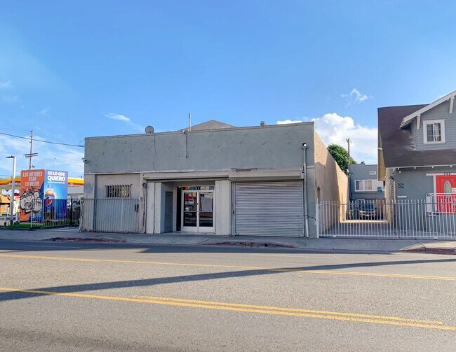
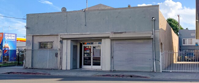
Property Record
512 W Vernon Ave, Los Angeles, CA 90037
NEARBY LISTINGS FOR SALE OR LEASE
Property Detail
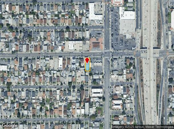
512 W Vernon Ave
Los Angeles-Long Beach-Glendale, CA
Bradford & Espes Figueroa & Vernon Ave
5018-033-016
BRADFORD AND ESPES FIGUEROA AND VERNON AVE TRACT EX OF ST LOT 50
Officebuilding
Los Angeles
X
California
06037C1618G
50
2024
0.17 AC
2025
South LA
232120
Los Angeles
6,820 SF
DEMOGRAPHICS near 512 W Vernon Ave
1 Mile
3 Mile
5 Mile
2024 Total Population
61,691
443,559
1,234,766
2029 Population
58,069
424,517
1,193,342
Pop Growth 2024-2029
(5.87%)
(4.29%)
(3.35%)
Average Age
34
36
37
2024 Total Households
14,822
125,234
407,610
HH Growth 2024-2029
(6.57%)
(4.29%)
(3.23%)
Median Household Inc
$45,698
$47,904
$50,381
Avg Household Size
3.60
3.30
2.80
2024 Avg HH Vehicles
2.00
2.00
1.00
Median Home Value
$616,674
$653,443
$700,846
Median Year Built
1948
1949
1955
Nearby Places
Map Layers
Map Styles
 Street
 Aerial
- Restaurants
- Banks
- Shops
- Fitness
- Groceries
PUBLIC TRANSPORTATION
COMMUTER RAIL
DRIVE
WALK
Distance
10 min
5.8 mi
Union Station (91 Line - Southern California Regional Rail Authority (Metrolink), Antelope Valley Line - Southern California Regional Rail Authority (Metrolink), Orange County Line - Southern California Regional Rail Authority (Metrolink), Riverside Line - Southern California Regional Rail Authority (Metrolink), San Bernardino Line - Southern California Regional Rail Authority (Metrolink), Ventura County Line - Southern California Regional Rail Authority (Metrolink))
DRIVE
WALK
Distance
Union Station (91 Line - Southern California Regional Rail Authority (Metrolink), Antelope Valley Line - Southern California Regional Rail Authority (Metrolink), Orange County Line - Southern California Regional Rail Authority (Metrolink), Riverside Line - Southern California Regional Rail Authority (Metrolink), San Bernardino Line - Southern California Regional Rail Authority (Metrolink), Ventura County Line - Southern California Regional Rail Authority (Metrolink))
12 min
6.0 mi
AIRPORT
Los Angeles International
DRIVE
WALK
Distance
Los Angeles International
20 min
13.9 mi
Long Beach (Daugherty Field)
DRIVE
WALK
Distance
Long Beach (Daugherty Field)
26 min
19.0 mi
Bob Hope
DRIVE
WALK
Distance
Bob Hope
30 min
21.0 mi
Freight Ports
Port of Long Beach
DRIVE
WALK
Distance
Port of Long Beach
30 min
21.0 mi
SALE & LEASE HISTORY
LISTING DATE
SALE/LEASE

Sep 25, 2016
For Lease
Sep 24, 2016
For Sale
Mar 28, 2022
For Lease
Jul 21, 2021
For Sale
Jan 23, 2019
For Sale
Feb 28, 2023
For Lease
Feb 24, 2017
For Sale
Feb 08, 2023
For Sale
Nearby Properties
Address
Land Use
TOTAL SIZE
Lot Size
Zoning
Address
Land Use
TOTAL SIZE
Lot Size
Zoning
969,516 SF
14.75 AC
Address
Land Use
TOTAL SIZE
Lot Size
Zoning
200,811 SF
4.59 AC
LALASED
Address
Land Use
TOTAL SIZE
Lot Size
Zoning
1,178,786 SF
3.89 AC
LAC2
Address
Land Use
TOTAL SIZE
Lot Size
Zoning
764,804 SF
1.48 AC
Address
Land Use
TOTAL SIZE
Lot Size
Zoning
420,864 SF
63.07 AC
LAUSC-1A
Address
Land Use
TOTAL SIZE
Lot Size
Zoning
574,047 SF
1.70 AC
LAR5
Address
Land Use
TOTAL SIZE
Lot Size
Zoning
256,059 SF
Address
Land Use
TOTAL SIZE
Lot Size
Zoning
200,689 SF
5.79 AC
LAUSC-1A
Address
Land Use
TOTAL SIZE
Lot Size
Zoning
50,048 SF
1.16 AC
LAR5
Address
Land Use
TOTAL SIZE
Lot Size
Zoning
337,025 SF
14.59 AC
LAUSC-1A
Address
Land Use
TOTAL SIZE
Lot Size
Zoning
666,499 SF
10.63 AC
LAC2
Address
Land Use
TOTAL SIZE
Lot Size
Zoning
298,630 SF
4.64 AC
LAUSC-1B
Address
Land Use
TOTAL SIZE
Lot Size
Zoning
448,914 SF
2.67 AC
LAC2
Address
Land Use
TOTAL SIZE
Lot Size
Zoning
311,717 SF
1.45 AC
LAR5
Address
Land Use
TOTAL SIZE
Lot Size
Zoning
1,027,870 SF
2.02 AC
LAC2
Address
Land Use
TOTAL SIZE
Lot Size
Zoning
377,946 SF
5.03 AC
LAUSC-1A
Address
Land Use
TOTAL SIZE
Lot Size
Zoning
269,786 SF
1.76 AC
LAR5
Address
Land Use
TOTAL SIZE
Lot Size
Zoning
236,423 SF
9.17 AC
LALASED
Address
Land Use
TOTAL SIZE
Lot Size
Zoning
279,351 SF
1.25 AC
LAC2
Address
Land Use
TOTAL SIZE
Lot Size
Zoning
277,250 SF
1.60 AC
LAC2
Address
Land Use
TOTAL SIZE
Lot Size
Zoning
235,687 SF
0.66 AC
LAR5
Address
Land Use
TOTAL SIZE
Lot Size
Zoning
186,931 SF
1.15 AC
LAR5
Address
Land Use
TOTAL SIZE
Lot Size
Zoning
242,190 SF
1.84 AC
LAC-4D-O
Address
Land Use
TOTAL SIZE
Lot Size
Zoning
152,000 SF
1.04 AC
LAC2
Address
Land Use
TOTAL SIZE
Lot Size
Zoning
690,514 SF
LACM
Address
Land Use
TOTAL SIZE
Lot Size
Zoning
112,636 SF
24.20 AC
LAUSC-1A
Address
Land Use
TOTAL SIZE
Lot Size
Zoning
284,335 SF
2.01 AC
LAM1
Address
Land Use
TOTAL SIZE
Lot Size
Zoning
216,569 SF
1.08 AC
LAC2
Address
Land Use
TOTAL SIZE
Lot Size
Zoning
95,053 SF
0.20 AC
LAC2
Address
Land Use
TOTAL SIZE
Lot Size
Zoning
200,780 SF
1.06 AC
LAC2
The World's #1 Commercial Real Estate Marketplace
Connect with us
© 2025 CoStar Group
The information above has been obtained from sources believed reliable. While we do not doubt its accuracy we have not verified it and make no guarantee, warranty or representation about it. It is your responsibility to independently confirm its accuracy and completeness. Any projections, opinions, assumptions, or estimates used are for example only and do not represent the current or future performance of the property. The value of this transaction to you depends on tax and other factors which should be evaluated by your tax, financial, and legal advisors. You and your advisors should conduct a careful, independent investigation of the property to determine to your satisfaction the suitability of the property for your needs.