Property Record
512 N Alexandria Ave, Los Angeles, CA 90004
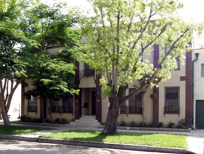

This Property Is For Sale
NEARBY LISTINGS FOR SALE OR LEASE
Property Detail
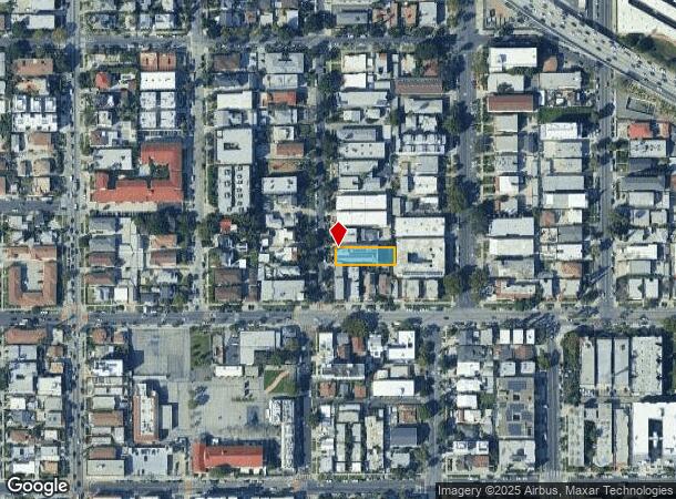
512 N Alexandria Ave
Los Angeles-Long Beach-Glendale, CA
Pioneer Investment & Trust Cos
5520-009-025
PIONEER INVESTMENT AND TRUST COS WINDERMERE PARK LOT 183
Multifamilydwelling
Los Angeles
X
California
06037C1610F
183
2024
0.20 AC
2025
East Hollywood
192610
Los Angeles
11,184 SF
DEMOGRAPHICS near 512 N Alexandria Ave
1 Mile
3 Mile
5 Mile
2024 Total Population
95,934
566,261
1,090,994
2029 Population
93,921
554,405
1,064,461
Pop Growth 2024-2029
(2.10%)
(2.09%)
(2.43%)
Average Age
38
39
39
2024 Total Households
37,814
241,227
458,512
HH Growth 2024-2029
(2.35%)
(2.15%)
(2.42%)
Median Household Inc
$51,980
$56,357
$60,740
Avg Household Size
2.40
2.20
2.20
2024 Avg HH Vehicles
1.00
1.00
1.00
Median Home Value
$971,062
$1,052,749
$996,655
Median Year Built
1961
1961
1961
Nearby Places
Map Layers
Map Styles
 Street
 Aerial
- Restaurants
- Banks
- Shops
- Fitness
- Groceries
PUBLIC TRANSPORTATION
TRANSIT/SUBWAY
Vermont/Beverly Station (Red Line - Los Angeles County Metropolitan Transportation Authority (Metro))
DRIVE
WALK
Distance
Vermont/Beverly Station (Red Line - Los Angeles County Metropolitan Transportation Authority (Metro))
1 min
11 min
0.6 mi
Vermont/Santa Monica Station (Red Line - Los Angeles County Metropolitan Transportation Authority (Metro))
DRIVE
WALK
Distance
Vermont/Santa Monica Station (Red Line - Los Angeles County Metropolitan Transportation Authority (Metro))
2 min
20 min
1.1 mi
COMMUTER RAIL
Los Angeles (Coast Starlight - Amtrak, Pacific Surfliner - Amtrak, Southwest Chief - Amtrak, Texas Eagle - Amtrak)
DRIVE
WALK
Distance
Los Angeles (Coast Starlight - Amtrak, Pacific Surfliner - Amtrak, Southwest Chief - Amtrak, Texas Eagle - Amtrak)
8 min
4.2 mi
Glendale (Antelope Valley Line - Southern California Regional Rail Authority (Metrolink), Ventura County Line - Southern California Regional Rail Authority (Metrolink))
DRIVE
WALK
Distance
Glendale (Antelope Valley Line - Southern California Regional Rail Authority (Metrolink), Ventura County Line - Southern California Regional Rail Authority (Metrolink))
10 min
5.4 mi
AIRPORT
Bob Hope
DRIVE
WALK
Distance
Bob Hope
19 min
11.1 mi
Los Angeles International
DRIVE
WALK
Distance
Los Angeles International
26 min
13.8 mi
Long Beach (Daugherty Field)
DRIVE
WALK
Distance
Long Beach (Daugherty Field)
35 min
25.3 mi
Freight Ports
Port of Long Beach
DRIVE
WALK
Distance
Port of Long Beach
38 min
27.2 mi
Nearby Properties
Address
Land Use
TOTAL SIZE
Lot Size
Zoning
Address
Land Use
TOTAL SIZE
Lot Size
Zoning
930,249 SF
7.39 AC
LAC2
Address
Land Use
TOTAL SIZE
Lot Size
Zoning
108,464 SF
9.17 AC
LALASED
Address
Land Use
TOTAL SIZE
Lot Size
Zoning
969,264 SF
0.94 AC
LAC2
Address
Land Use
TOTAL SIZE
Lot Size
Zoning
949,529 SF
1.50 AC
LAC2
Address
Land Use
TOTAL SIZE
Lot Size
Zoning
709,584 SF
1.80 AC
LAPB
Address
Land Use
TOTAL SIZE
Lot Size
Zoning
738,975 SF
2.71 AC
LAC2
Address
Land Use
TOTAL SIZE
Lot Size
Zoning
161,046 SF
6.88 AC
LAM1
Address
Land Use
TOTAL SIZE
Lot Size
Zoning
67,126 SF
48.09 AC
LAM1
Address
Land Use
TOTAL SIZE
Lot Size
Zoning
472,363 SF
3.24 AC
LAC4
Address
Land Use
TOTAL SIZE
Lot Size
Zoning
641,453 SF
2.93 AC
LAC4
Address
Land Use
TOTAL SIZE
Lot Size
Zoning
497,377 SF
3.29 AC
LAC4
Address
Land Use
TOTAL SIZE
Lot Size
Zoning
651,289 SF
3.79 AC
LACW
Address
Land Use
TOTAL SIZE
Lot Size
Zoning
1.28 AC
LAC2
Address
Land Use
TOTAL SIZE
Lot Size
Zoning
724,958 SF
5.88 AC
LAC2
Address
Land Use
TOTAL SIZE
Lot Size
Zoning
520,825 SF
2.13 AC
LAC2
Address
Land Use
TOTAL SIZE
Lot Size
Zoning
289,633 SF
1.55 AC
LAP
Address
Land Use
TOTAL SIZE
Lot Size
Zoning
323,927 SF
0.85 AC
LALASED
Address
Land Use
TOTAL SIZE
Lot Size
Zoning
255,868 SF
9.58 AC
WDC2C*
Address
Land Use
TOTAL SIZE
Lot Size
Zoning
289,108 SF
0.57 AC
LAC2
Address
Land Use
TOTAL SIZE
Lot Size
Zoning
746,938 SF
0.98 AC
LAC4
Address
Land Use
TOTAL SIZE
Lot Size
Zoning
556,235 SF
4.22 AC
LAC4
Address
Land Use
TOTAL SIZE
Lot Size
Zoning
406,948 SF
8.04 AC
LAC2
Address
Land Use
TOTAL SIZE
Lot Size
Zoning
341,221 SF
1.84 AC
LAC4
Address
Land Use
TOTAL SIZE
Lot Size
Zoning
490,689 SF
3.60 AC
LAM1
Address
Land Use
TOTAL SIZE
Lot Size
Zoning
256,032 SF
4.69 AC
LAC4
Address
Land Use
TOTAL SIZE
Lot Size
Zoning
216,433 SF
1.38 AC
LAR5
Address
Land Use
TOTAL SIZE
Lot Size
Zoning
320,944 SF
1.97 AC
LAC4
Address
Land Use
TOTAL SIZE
Lot Size
Zoning
264,720 SF
4.69 AC
LAC4
Address
Land Use
TOTAL SIZE
Lot Size
Zoning
310,063 SF
2.22 AC
LAC2
Address
Land Use
TOTAL SIZE
Lot Size
Zoning
259,502 SF
2 AC
LAC2
The World's #1 Commercial Real Estate Marketplace
Connect with us
© 2025 CoStar Group
The information above has been obtained from sources believed reliable. While we do not doubt its accuracy we have not verified it and make no guarantee, warranty or representation about it. It is your responsibility to independently confirm its accuracy and completeness. Any projections, opinions, assumptions, or estimates used are for example only and do not represent the current or future performance of the property. The value of this transaction to you depends on tax and other factors which should be evaluated by your tax, financial, and legal advisors. You and your advisors should conduct a careful, independent investigation of the property to determine to your satisfaction the suitability of the property for your needs.