Property Record
5135 Paramount Blvd, Pico Rivera, CA 90660


Save to a Folder
{{folder.Name}}
{{folder.ListingIds.length}} Properties
{{folder.ListingIds.length}} Property
Create a New Folder
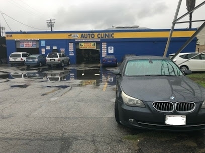
Property Detail
5135 Paramount Blvd
6348-022-030
RANCHO PASO DE BARTOLO FINALLY CONFIRMED TO PIO PICO ET AL LOT EX T/L EASE COM SW ON NW LINE OF PARAMOUNT BLVD PER CSB1564-2, 839.56 FT FROM INTERSECTION OF SD NW LINE WITH SW LINE OF WHITTIER A UNIFORM DEPTH OF 209.62 FT N 62 45 W
Autorepair
Los Angeles
PRIG-OS*
California
2025
0.55 AC
2025
Montebello
500700
Los Angeles
4,928 SF
Los Angeles-Long Beach-Glendale, CA
NEARBY LISTINGS FOR SALE OR LEASE
DEMOGRAPHICS near 5135 Paramount Blvd
1 mile
3 mile
5 mile
2025 Total Population
25,872
174,550
501,473
2030 Population
25,335
171,671
493,628
Pop Growth 2025-2030
(2.08%)
(1.65%)
(1.56%)
Average Age
40
40
40
2025 Total Households
7,066
51,290
146,408
HH Growth 2025-2030
(2.34%)
(1.89%)
(1.81%)
Median Household Inc
$72,789
$86,139
$80,481
Avg Household Size
3.50
3.30
3.30
2025 Avg HH Vehicles
2.00
2.00
2.00
Median Home Value
$688,660
$722,048
$740,412
Median Year Built
1956
1957
1957
Nearby Places
Map Layers
Map Styles
 Street
 Aerial
Layers
 Traffic
 Biking
Places
Listings with unknown addresses are not visible on the map
- Restaurants
- Banks
- Shops
- Fitness
- Groceries
PUBLIC TRANSPORTATION
COMMUTER RAIL
Montebello/ Commerce Metrolink Station (Metrolink Riverside Line - Metrolink Trains)
Drive
Walk
Distance
Montebello/ Commerce Metrolink Station (Metrolink Riverside Line - Metrolink Trains)
7 min
2.8 mi
Commerce Metrolink Station (Metrolink Orange County Line - Metrolink Trains)
Drive
Walk
Distance
Commerce Metrolink Station (Metrolink Orange County Line - Metrolink Trains)
10 min
4.8 mi
AIRPORT
Long Beach (Daugherty Field)
Drive
Walk
Distance
Long Beach (Daugherty Field)
27 min
18.2 mi
Los Angeles International
Drive
Walk
Distance
Los Angeles International
34 min
26.5 mi
Bob Hope
Drive
Walk
Distance
Bob Hope
38 min
27.1 mi
Freight Ports
Port of Long Beach
Drive
Walk
Distance
Port of Long Beach
33 min
23.9 mi
Nearby Properties
Address
Land Use
TOTAL SIZE
Lot Size
Zoning
Address
Land Use
TOTAL SIZE
Lot Size
Zoning
884,553 SF
13.63 AC
RMC3*
Address
Land Use
TOTAL SIZE
Lot Size
Zoning
347,306 SF
14.37 AC
LCA25-CPD*
Address
Land Use
TOTAL SIZE
Lot Size
Zoning
137,162 SF
6.44 AC
Address
Land Use
TOTAL SIZE
Lot Size
Zoning
304,520 SF
14.18 AC
LCA25-CPD*
Address
Land Use
TOTAL SIZE
Lot Size
Zoning
234,324 SF
10.05 AC
SSM2*
Address
Land Use
TOTAL SIZE
Lot Size
Zoning
98,118 SF
14.95 AC
Address
Land Use
TOTAL SIZE
Lot Size
Zoning
244,768 SF
10.59 AC
PR1G
Address
Land Use
TOTAL SIZE
Lot Size
Zoning
875,558 SF
24.08 AC
CMM2*
Address
Land Use
TOTAL SIZE
Lot Size
Zoning
170,222 SF
7.50 AC
PR1G
Address
Land Use
TOTAL SIZE
Lot Size
Zoning
173,100 SF
7.83 AC
PRIG*
Address
Land Use
TOTAL SIZE
Lot Size
Zoning
155,920 SF
12.13 AC
MPM*
Address
Land Use
TOTAL SIZE
Lot Size
Zoning
168,548 SF
7.53 AC
CMM2*
Address
Land Use
TOTAL SIZE
Lot Size
Zoning
188,940 SF
9 AC
PR1G
Address
Land Use
TOTAL SIZE
Lot Size
Zoning
88,801 SF
10.59 AC
MNC2*
Address
Land Use
TOTAL SIZE
Lot Size
Zoning
513,222 SF
13.35 AC
PR1G
Address
Land Use
TOTAL SIZE
Lot Size
Zoning
159,960 SF
6.22 AC
MNR3*
Address
Land Use
TOTAL SIZE
Lot Size
Zoning
1,094,138 SF
23.73 AC
CMM2YY
Address
Land Use
TOTAL SIZE
Lot Size
Zoning
183,034 SF
19.57 AC
IDM11/2*
Address
Land Use
TOTAL SIZE
Lot Size
Zoning
118,026 SF
5.73 AC
CMM2*
Address
Land Use
TOTAL SIZE
Lot Size
Zoning
74,018 SF
14.92 AC
WHM1*
Address
Land Use
TOTAL SIZE
Lot Size
Zoning
244,390 SF
12.99 AC
CMM2
Address
Land Use
TOTAL SIZE
Lot Size
Zoning
826,068 SF
21.11 AC
Address
Land Use
TOTAL SIZE
Lot Size
Zoning
107,778 SF
8.87 AC
MPM*
Address
Land Use
TOTAL SIZE
Lot Size
Zoning
102,761 SF
4.47 AC
CMM2YY
Address
Land Use
TOTAL SIZE
Lot Size
Zoning
331,322 SF
13.69 AC
MNM2*
Address
Land Use
TOTAL SIZE
Lot Size
Zoning
621,229 SF
7.98 AC
MPM*
Address
Land Use
TOTAL SIZE
Lot Size
Zoning
244,489 SF
6.73 AC
CMM2*
Address
Land Use
TOTAL SIZE
Lot Size
Zoning
313,965 SF
8.22 AC
PRCG*
Address
Land Use
TOTAL SIZE
Lot Size
Zoning
221,850 SF
17.91 AC
PR1G
Address
Land Use
TOTAL SIZE
Lot Size
Zoning
66,102 SF
1.90 AC
MPCM*
The World's #1 Commercial Real Estate Marketplace
Connect with us
© 2026 CoStar Group
The information above has been obtained from sources believed reliable. While we do not doubt its accuracy we have not verified it and make no guarantee, warranty or representation about it. It is your responsibility to independently confirm its accuracy and completeness. Any projections, opinions, assumptions, or estimates used are for example only and do not represent the current or future performance of the property. The value of this transaction to you depends on tax and other factors which should be evaluated by your tax, financial, and legal advisors. You and your advisors should conduct a careful, independent investigation of the property to determine to your satisfaction the suitability of the property for your needs.