Property Record
515 E 7Th St, Maryville, MO 64468
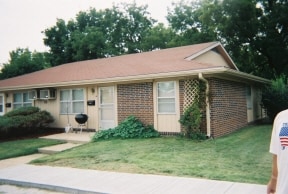
This Property Is For Sale
Property Detail
515 E 7Th St
Maryville, MO
COM 30 E & 333 N OF SW COR LOT 5 N BDRY OF OT TH N 92' TH W 30' TH N 96' TH SE 388.83'; TH S 105'; TH SW 136.99'; TH W 88.88'
22-04-17-03-01-06801
NODAWAY
Apartment
Missouri
B and X Area of moderate flood hazard, usually the area between the limits of the 100-year and 500-year floods.
5
2025
1.57 AC
2025
Missouri North Area
470400
Other Market Areas
2,989 SF
NEARBY LISTINGS FOR SALE OR LEASE
DEMOGRAPHICS near 515 E 7Th St
1 mile
3 mile
5 mile
2025 Total Population
6,885
12,112
13,091
2030 Population
6,722
11,783
12,707
Pop Growth 2025-2030
(2.37%)
(2.72%)
(2.93%)
Average Age
33
35
36
2025 Total Households
2,752
4,768
5,100
HH Growth 2025-2030
(2.87%)
(3.23%)
(3.49%)
Median Household Inc
$42,929
$50,914
$52,451
Avg Household Size
2.10
2.20
2.20
2025 Avg HH Vehicles
2.00
2.00
2.00
Median Home Value
$164,476
$204,771
$210,024
Median Year Built
1973
1976
1976
Nearby Places
Map Layers
Map Styles
 Street
 Aerial
Layers
 Traffic
 Biking
Places
Listings with unknown addresses are not visible on the map
- Restaurants
- Banks
- Shops
- Fitness
- Groceries
Nearby Properties
Address
Land Use
TOTAL SIZE
Lot Size
Zoning
Address
Land Use
TOTAL SIZE
Lot Size
Zoning
36,840 SF
5.30 AC
Address
Land Use
TOTAL SIZE
Lot Size
Zoning
7,392 SF
2.77 AC
Address
Land Use
TOTAL SIZE
Lot Size
Zoning
3,000 SF
1.39 AC
Address
Land Use
TOTAL SIZE
Lot Size
Zoning
9,954 SF
5.35 AC
Address
Land Use
TOTAL SIZE
Lot Size
Zoning
5,599 SF
0.85 AC
Address
Land Use
TOTAL SIZE
Lot Size
Zoning
3,096 SF
1.46 AC
Address
Land Use
TOTAL SIZE
Lot Size
Zoning
1.25 AC
Address
Land Use
TOTAL SIZE
Lot Size
Zoning
5,280 SF
1.41 AC
Address
Land Use
TOTAL SIZE
Lot Size
Zoning
4,500 SF
0.40 AC
Address
Land Use
TOTAL SIZE
Lot Size
Zoning
12,160 SF
26.49 AC
Address
Land Use
TOTAL SIZE
Lot Size
Zoning
0.51 AC
Address
Land Use
TOTAL SIZE
Lot Size
Zoning
0.42 AC
Address
Land Use
TOTAL SIZE
Lot Size
Zoning
2,852 SF
0.75 AC
Address
Land Use
TOTAL SIZE
Lot Size
Zoning
1,536 SF
0.40 AC
Address
Land Use
TOTAL SIZE
Lot Size
Zoning
Address
Land Use
TOTAL SIZE
Lot Size
Zoning
17.09 AC
Address
Land Use
TOTAL SIZE
Lot Size
Zoning
1,813 SF
0.49 AC
Address
Land Use
TOTAL SIZE
Lot Size
Zoning
Address
Land Use
TOTAL SIZE
Lot Size
Zoning
8,052 SF
3 AC
Address
Land Use
TOTAL SIZE
Lot Size
Zoning
11.29 AC
Address
Land Use
TOTAL SIZE
Lot Size
Zoning
3,296 SF
0.71 AC
Address
Land Use
TOTAL SIZE
Lot Size
Zoning
0.26 AC
Address
Land Use
TOTAL SIZE
Lot Size
Zoning
5,112 SF
5.40 AC
Address
Land Use
TOTAL SIZE
Lot Size
Zoning
3,296 SF
0.69 AC
Address
Land Use
TOTAL SIZE
Lot Size
Zoning
1,248 SF
1.02 AC
Address
Land Use
TOTAL SIZE
Lot Size
Zoning
3,096 SF
0.86 AC
Address
Land Use
TOTAL SIZE
Lot Size
Zoning
0.25 AC
Address
Land Use
TOTAL SIZE
Lot Size
Zoning
3,096 SF
0.73 AC
Address
Land Use
TOTAL SIZE
Lot Size
Zoning
3,096 SF
0.73 AC
The World's #1 Commercial Real Estate Marketplace
Connect with us
© 2026 CoStar Group
The information above has been obtained from sources believed reliable. While we do not doubt its accuracy we have not verified it and make no guarantee, warranty or representation about it. It is your responsibility to independently confirm its accuracy and completeness. Any projections, opinions, assumptions, or estimates used are for example only and do not represent the current or future performance of the property. The value of this transaction to you depends on tax and other factors which should be evaluated by your tax, financial, and legal advisors. You and your advisors should conduct a careful, independent investigation of the property to determine to your satisfaction the suitability of the property for your needs.