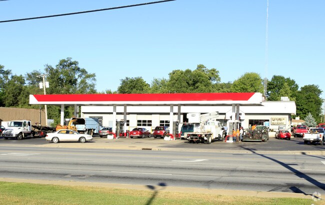
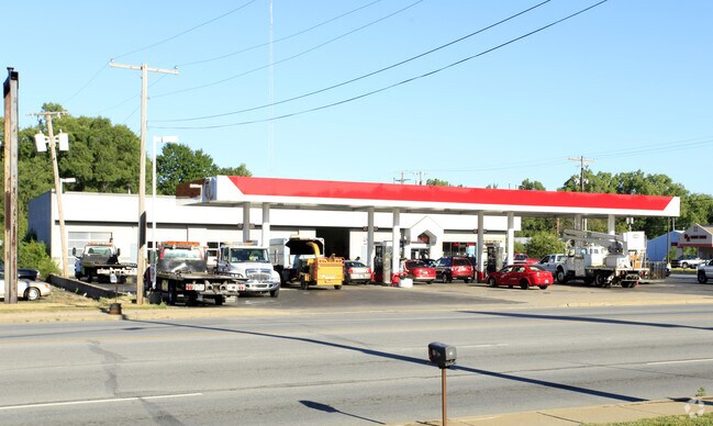
Property Record
51519 Us31 Rick N, South Bend, IN 46637
NEARBY LISTINGS FOR SALE OR LEASE
Property Detail
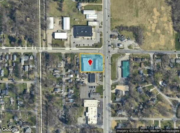
51519 Us31 Rick N
South Bend-Mishawaka, IN-MI
Ponds
71-03-13-306-006.000-003
LOTS 1 & 2 EX TRI NE COR TO STATE AND LOTS 31 & 30 ALL IN MARKHAM PRO W 1/2 SW 1/4 SEC 13-38-2E 21/22 CON W/ 002-1071-3191 & -3190 PER ASSESSOR REQ IC 6-1.1-5-16 SOLD 06-30-93
Servicestation
St Joseph
X
Indiana
18141C0182D
1-2,1
2023
0.94 AC
2024
Outlying St Joseph County
011308
South Bend/Mishawaka
9,035 SF
DEMOGRAPHICS near 51519 Us31 Rick N
1 Mile
3 Mile
5 Mile
2024 Total Population
4,916
34,028
109,024
2029 Population
4,862
33,653
109,073
Pop Growth 2024-2029
(1.10%)
(1.10%)
+ 0.04%
Average Age
42
42
38
2024 Total Households
2,029
13,936
42,365
HH Growth 2024-2029
(1.13%)
(1.18%)
+ 0.04%
Median Household Inc
$75,167
$75,571
$60,520
Avg Household Size
2.30
2.30
2.30
2024 Avg HH Vehicles
2.00
2.00
2.00
Median Home Value
$159,842
$182,654
$175,923
Median Year Built
1968
1975
1972
Nearby Places
Map Layers
Map Styles
 Street
 Aerial
- Restaurants
- Banks
- Shops
- Fitness
- Groceries
PUBLIC TRANSPORTATION
COMMUTER RAIL
South Bend Airport Station (South Shore Line - Northern Indiana Commuter Transportation District (South Shore Line))
DRIVE
WALK
Distance
South Bend Airport Station (South Shore Line - Northern Indiana Commuter Transportation District (South Shore Line))
14 min
6.5 mi
South Bend Amtrak Station (Capitol Limited - Amtrak, Lake Shore Limited - Amtrak)
DRIVE
WALK
Distance
South Bend Amtrak Station (Capitol Limited - Amtrak, Lake Shore Limited - Amtrak)
14 min
6.5 mi
AIRPORT
South Bend International
DRIVE
WALK
Distance
South Bend International
25 min
9.4 mi
Freight Ports
Port Milwaukee
DRIVE
WALK
Distance
Port Milwaukee
218 min
180.4 mi
Nearby Properties
Address
Land Use
TOTAL SIZE
Lot Size
Zoning
Address
Land Use
TOTAL SIZE
Lot Size
Zoning
3,879,729 SF
436.76 AC
Address
Land Use
TOTAL SIZE
Lot Size
Zoning
369,116 SF
19.80 AC
Address
Land Use
TOTAL SIZE
Lot Size
Zoning
538,338 SF
0.01 AC
Address
Land Use
TOTAL SIZE
Lot Size
Zoning
160,546 SF
Address
Land Use
TOTAL SIZE
Lot Size
Zoning
151,377 SF
0.01 AC
Address
Land Use
TOTAL SIZE
Lot Size
Zoning
799,664 SF
0.01 AC
Address
Land Use
TOTAL SIZE
Lot Size
Zoning
25,756 SF
337.40 AC
Address
Land Use
TOTAL SIZE
Lot Size
Zoning
356,520 SF
28.07 AC
Address
Land Use
TOTAL SIZE
Lot Size
Zoning
174,997 SF
0.70 AC
Address
Land Use
TOTAL SIZE
Lot Size
Zoning
128,298 SF
0.84 AC
Address
Land Use
TOTAL SIZE
Lot Size
Zoning
73,254 SF
96.72 AC
Address
Land Use
TOTAL SIZE
Lot Size
Zoning
747,842 SF
30.05 AC
Address
Land Use
TOTAL SIZE
Lot Size
Zoning
142,065 SF
44 SF
Address
Land Use
TOTAL SIZE
Lot Size
Zoning
140,994 SF
13.58 AC
Address
Land Use
TOTAL SIZE
Lot Size
Zoning
159,834 SF
44 SF
Address
Land Use
TOTAL SIZE
Lot Size
Zoning
157,702 SF
44 SF
Address
Land Use
TOTAL SIZE
Lot Size
Zoning
114,844 SF
4.17 AC
Address
Land Use
TOTAL SIZE
Lot Size
Zoning
63,780 SF
44 SF
Address
Land Use
TOTAL SIZE
Lot Size
Zoning
178,316 SF
44 SF
Address
Land Use
TOTAL SIZE
Lot Size
Zoning
214,657 SF
131 SF
Address
Land Use
TOTAL SIZE
Lot Size
Zoning
203,750 SF
22.36 AC
Address
Land Use
TOTAL SIZE
Lot Size
Zoning
63,374 SF
1.99 AC
Address
Land Use
TOTAL SIZE
Lot Size
Zoning
255,684 SF
23.71 AC
Address
Land Use
TOTAL SIZE
Lot Size
Zoning
58,213 SF
87 SF
Address
Land Use
TOTAL SIZE
Lot Size
Zoning
70,170 SF
4.01 AC
Address
Land Use
TOTAL SIZE
Lot Size
Zoning
266,881 SF
26.20 AC
Address
Land Use
TOTAL SIZE
Lot Size
Zoning
63,696 SF
5 AC
Address
Land Use
TOTAL SIZE
Lot Size
Zoning
62,968 SF
2.66 AC
Address
Land Use
TOTAL SIZE
Lot Size
Zoning
17,176 SF
73 AC
Address
Land Use
TOTAL SIZE
Lot Size
Zoning
74,400 SF
1.13 AC
The World's #1 Commercial Real Estate Marketplace
Connect with us
© 2025 CoStar Group
The information above has been obtained from sources believed reliable. While we do not doubt its accuracy we have not verified it and make no guarantee, warranty or representation about it. It is your responsibility to independently confirm its accuracy and completeness. Any projections, opinions, assumptions, or estimates used are for example only and do not represent the current or future performance of the property. The value of this transaction to you depends on tax and other factors which should be evaluated by your tax, financial, and legal advisors. You and your advisors should conduct a careful, independent investigation of the property to determine to your satisfaction the suitability of the property for your needs.