Property Record
911 Springfield Rd, Fayetteville, NC 28301
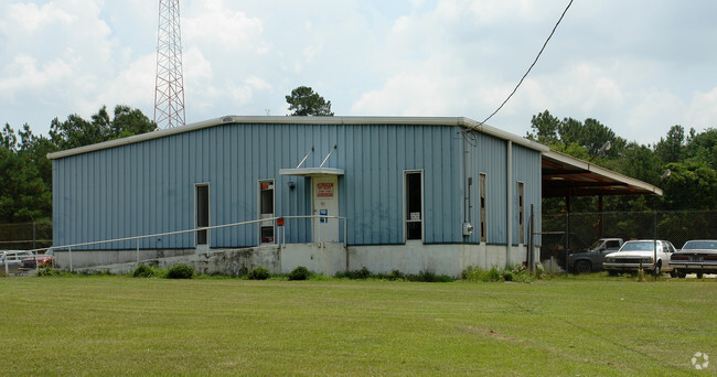


This Property Is For Sale
NEARBY LISTINGS FOR SALE OR LEASE
Property Detail
911 Springfield Rd
Fayetteville, NC
Murchison Rd/Rowan To Pamalee
0428-76-6107
LD PL:0040-0046
Publicstorage
Cumberland
X
North Carolina
3720042800J
6107
2025
3.81 AC
2025
North Fayetteville
003800
Fayetteville
1,400 SF
DEMOGRAPHICS near 911 Springfield Rd
1 Mile
3 Mile
5 Mile
2024 Total Population
8,099
53,605
115,252
2029 Population
8,227
53,830
115,557
Pop Growth 2024-2029
+ 1.58%
+ 0.42%
+ 0.26%
Average Age
37
39
38
2024 Total Households
2,960
23,013
49,270
HH Growth 2024-2029
+ 1.72%
+ 0.42%
+ 0.28%
Median Household Inc
$33,901
$42,561
$46,777
Avg Household Size
2.20
2.20
2.20
2024 Avg HH Vehicles
1.00
1.00
2.00
Median Home Value
$111,303
$164,990
$156,260
Median Year Built
1967
1974
1977
Nearby Places
Map Layers
Map Styles
 Street
 Aerial
- Restaurants
- Banks
- Shops
- Fitness
- Groceries
PUBLIC TRANSPORTATION
COMMUTER RAIL
DRIVE
WALK
Distance
5 min
2.8 mi
AIRPORT
Fayetteville Regional/Grannis Field
DRIVE
WALK
Distance
Fayetteville Regional/Grannis Field
14 min
8.3 mi
Nearby Properties
Address
Land Use
TOTAL SIZE
Lot Size
Zoning
Address
Land Use
TOTAL SIZE
Lot Size
Zoning
2,193 SF
133.52 AC
MR5
Address
Land Use
TOTAL SIZE
Lot Size
Zoning
46,110 SF
25.72 AC
OI
Address
Land Use
TOTAL SIZE
Lot Size
Zoning
91,620 SF
9.67 AC
CC
Address
Land Use
TOTAL SIZE
Lot Size
Zoning
11,894 SF
8.39 AC
DTCZ
Address
Land Use
TOTAL SIZE
Lot Size
Zoning
2,842 SF
23.27 AC
MR5
Address
Land Use
TOTAL SIZE
Lot Size
Zoning
3,999 SF
44.59 AC
MR5
Address
Land Use
TOTAL SIZE
Lot Size
Zoning
1,920 SF
14.88 AC
MR5
Address
Land Use
TOTAL SIZE
Lot Size
Zoning
1,352 SF
43.38 AC
MR5
Address
Land Use
TOTAL SIZE
Lot Size
Zoning
4,380 SF
33.27 AC
SF10
Address
Land Use
TOTAL SIZE
Lot Size
Zoning
7,434 SF
5.87 AC
R5CZ
Address
Land Use
TOTAL SIZE
Lot Size
Zoning
1,682 SF
30.53 AC
CC-COMMUNI
Address
Land Use
TOTAL SIZE
Lot Size
Zoning
1 AC
DTCZ
Address
Land Use
TOTAL SIZE
Lot Size
Zoning
2,797 SF
54.38 AC
(UC) UNIVE
Address
Land Use
TOTAL SIZE
Lot Size
Zoning
29,896 SF
58.43 AC
SF6
Address
Land Use
TOTAL SIZE
Lot Size
Zoning
1 AC
DTCZ-DOWNT
Address
Land Use
TOTAL SIZE
Lot Size
Zoning
212,754 SF
29.98 AC
CC
Address
Land Use
TOTAL SIZE
Lot Size
Zoning
27,825 SF
1.67 AC
DT
Address
Land Use
TOTAL SIZE
Lot Size
Zoning
10,158 SF
11.49 AC
SF6
Address
Land Use
TOTAL SIZE
Lot Size
Zoning
26,818 SF
OI-OFFICE
Address
Land Use
TOTAL SIZE
Lot Size
Zoning
104,350 SF
23.28 AC
CC
Address
Land Use
TOTAL SIZE
Lot Size
Zoning
4,602 SF
29.92 AC
MR5
Address
Land Use
TOTAL SIZE
Lot Size
Zoning
65,113 SF
28.39 AC
SF6
Address
Land Use
TOTAL SIZE
Lot Size
Zoning
194,874 SF
24.60 AC
CC
Address
Land Use
TOTAL SIZE
Lot Size
Zoning
103,072 SF
21.71 AC
CC
Address
Land Use
TOTAL SIZE
Lot Size
Zoning
152,924 SF
18.14 AC
CC
Address
Land Use
TOTAL SIZE
Lot Size
Zoning
40,786 SF
3.80 AC
DT
Address
Land Use
TOTAL SIZE
Lot Size
Zoning
16,366 SF
3.20 AC
CC
Address
Land Use
TOTAL SIZE
Lot Size
Zoning
1,920 SF
16.30 AC
CC-COMMUNI
Address
Land Use
TOTAL SIZE
Lot Size
Zoning
15.13 AC
(UC) UNIVE
Address
Land Use
TOTAL SIZE
Lot Size
Zoning
40,590 SF
27.97 AC
SF6
The World's #1 Commercial Real Estate Marketplace
Connect with us
© 2026 CoStar Group
The information above has been obtained from sources believed reliable. While we do not doubt its accuracy we have not verified it and make no guarantee, warranty or representation about it. It is your responsibility to independently confirm its accuracy and completeness. Any projections, opinions, assumptions, or estimates used are for example only and do not represent the current or future performance of the property. The value of this transaction to you depends on tax and other factors which should be evaluated by your tax, financial, and legal advisors. You and your advisors should conduct a careful, independent investigation of the property to determine to your satisfaction the suitability of the property for your needs.