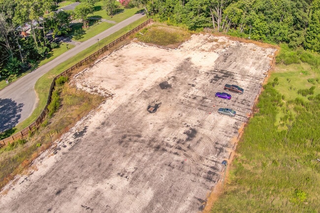
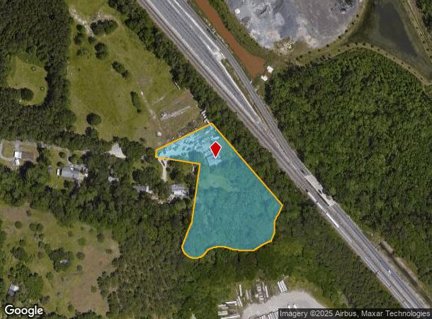
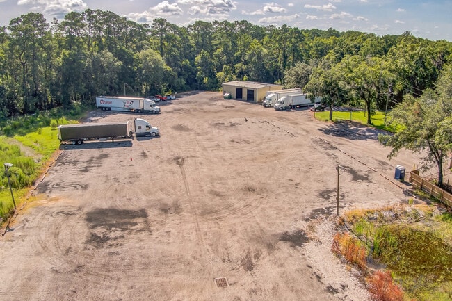
Property Record
5196 Pickett Dr, Jacksonville, FL 32219
Current Lease Availabilities
NEARBY LISTINGS FOR SALE OR LEASE
Property Detail
5196 Pickett Dr
029908-0220
Section Land
Warehouse
39-1S-26E 3.16 SIBBALD GRANT PT RECD O/R 20650-1830 BEING PARCEL 3
AE
Duval
12031C0351H
Florida
2024
4.52 AC
2025
Northwest Jacksonville
010601
Jacksonville (Florida)
2,400 SF
Jacksonville, FL
DEMOGRAPHICS near 5196 Pickett Dr
1 Mile
3 Mile
5 Mile
2024 Total Population
2,933
42,124
140,745
2029 Population
3,092
44,417
148,809
Pop Growth 2024-2029
+ 5.42%
+ 5.44%
+ 5.73%
Average Age
41
40
39
2024 Total Households
1,131
16,187
55,601
HH Growth 2024-2029
+ 5.57%
+ 5.55%
+ 5.82%
Median Household Inc
$33,982
$38,428
$38,018
Avg Household Size
2.50
2.50
2.40
2024 Avg HH Vehicles
1.00
1.00
1.00
Median Home Value
$142,562
$102,011
$135,310
Median Year Built
1968
1964
1963
Nearby Places
- Restaurants
- Banks
- Shops
- Fitness
- Groceries
PUBLIC TRANSPORTATION
COMMUTER RAIL
Jacksonville (Silver Meteor - Amtrak, Silver Star - Amtrak)
DRIVE
WALK
Distance
Jacksonville (Silver Meteor - Amtrak, Silver Star - Amtrak)
7 min
19 min
1.0 mi
AIRPORT
Jacksonville International
DRIVE
WALK
Distance
Jacksonville International
24 min
13.2 mi
Freight Ports
Jacksonville Port
DRIVE
WALK
Distance
Jacksonville Port
18 min
9.4 mi
Nearby Properties
Address
Land Use
TOTAL SIZE
Lot Size
Zoning
Address
Land Use
TOTAL SIZE
Lot Size
Zoning
973,797 SF
105.79 AC
PUD
Address
Land Use
TOTAL SIZE
Lot Size
Zoning
874,178 SF
46.91 AC
PBF-2
Address
Land Use
TOTAL SIZE
Lot Size
Zoning
600,857 SF
38.14 AC
IL
Address
Land Use
TOTAL SIZE
Lot Size
Zoning
465,664 SF
21.27 AC
IL
Address
Land Use
TOTAL SIZE
Lot Size
Zoning
352,439 SF
3.40 AC
CCBD
Address
Land Use
TOTAL SIZE
Lot Size
Zoning
449,967 SF
23.08 AC
IL
Address
Land Use
TOTAL SIZE
Lot Size
Zoning
449,367 SF
26.16 AC
PUD
Address
Land Use
TOTAL SIZE
Lot Size
Zoning
414,674 SF
21.03 AC
PUD
Address
Land Use
TOTAL SIZE
Lot Size
Zoning
392,050 SF
50.22 AC
PUD
Address
Land Use
TOTAL SIZE
Lot Size
Zoning
594,573 SF
27.69 AC
IL
Address
Land Use
TOTAL SIZE
Lot Size
Zoning
262,792 SF
15.23 AC
PUD
Address
Land Use
TOTAL SIZE
Lot Size
Zoning
299,588 SF
75.26 AC
IBP
Address
Land Use
TOTAL SIZE
Lot Size
Zoning
311,382 SF
18.57 AC
PUD
Address
Land Use
TOTAL SIZE
Lot Size
Zoning
307,732 SF
41.23 AC
IL
Address
Land Use
TOTAL SIZE
Lot Size
Zoning
302,066 SF
15.70 AC
IL
Address
Land Use
TOTAL SIZE
Lot Size
Zoning
277,582 SF
16.49 AC
IL
Address
Land Use
TOTAL SIZE
Lot Size
Zoning
397,865 SF
42 AC
IL
Address
Land Use
TOTAL SIZE
Lot Size
Zoning
117,227 SF
14.32 AC
CCG-2
Address
Land Use
TOTAL SIZE
Lot Size
Zoning
240,050 SF
28.53 AC
IBP
Address
Land Use
TOTAL SIZE
Lot Size
Zoning
317,474 SF
17.74 AC
IL
Address
Land Use
TOTAL SIZE
Lot Size
Zoning
249,082 SF
31.28 AC
PUD
Address
Land Use
TOTAL SIZE
Lot Size
Zoning
255,048 SF
20.15 AC
IL
Address
Land Use
TOTAL SIZE
Lot Size
Zoning
171,572 SF
10.47 AC
PUD
Address
Land Use
TOTAL SIZE
Lot Size
Zoning
197,164 SF
13.35 AC
PUD
Address
Land Use
TOTAL SIZE
Lot Size
Zoning
320,741 SF
56.62 AC
IL
Address
Land Use
TOTAL SIZE
Lot Size
Zoning
161,001 SF
10.32 AC
IL
Address
Land Use
TOTAL SIZE
Lot Size
Zoning
189,832 SF
13.08 AC
PUD
Address
Land Use
TOTAL SIZE
Lot Size
Zoning
176,798 SF
14.77 AC
PUD
Address
Land Use
TOTAL SIZE
Lot Size
Zoning
236,224 SF
14.13 AC
PUD
Address
Land Use
TOTAL SIZE
Lot Size
Zoning
296,575 SF
16.24 AC
PUD
The World's #1 Commercial Real Estate Marketplace
Connect with us
© 2025 CoStar Group
The information above has been obtained from sources believed reliable. While we do not doubt its accuracy we have not verified it and make no guarantee, warranty or representation about it. It is your responsibility to independently confirm its accuracy and completeness. Any projections, opinions, assumptions, or estimates used are for example only and do not represent the current or future performance of the property. The value of this transaction to you depends on tax and other factors which should be evaluated by your tax, financial, and legal advisors. You and your advisors should conduct a careful, independent investigation of the property to determine to your satisfaction the suitability of the property for your needs.