Property Record
52 Maxim Rd, Howell, NJ 07731
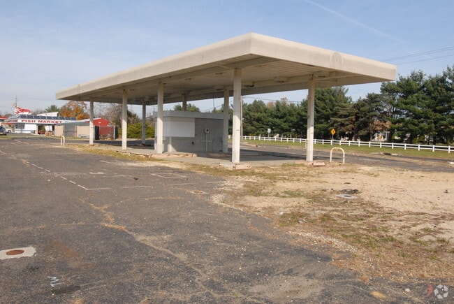

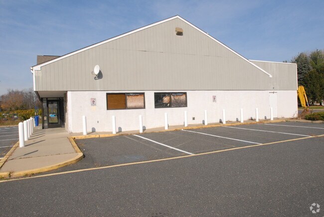
Property Detail
52 Maxim Rd
21-00053-0000-00020
Monmouth
Farms
New Jersey
ARE6
20
B and X Area of moderate flood hazard, usually the area between the limits of the 100-year and 500-year floods.
0.50 AC
2024
Western Monmouth
2025
Northern New Jersey
811200
Lakewood-New Brunswick, NJ
860 SF
NEARBY LISTINGS FOR SALE OR LEASE
DEMOGRAPHICS near 52 Maxim Rd
1 mile
3 mile
5 mile
2025 Total Population
3,326
24,206
121,807
2030 Population
3,284
23,960
120,779
Pop Growth 2025-2030
(1.26%)
(1.02%)
(0.84%)
Average Age
40
40
33
2025 Total Households
1,034
8,016
34,188
HH Growth 2025-2030
(1.55%)
(1.32%)
(1.40%)
Median Household Inc
$157,511
$130,441
$100,981
Avg Household Size
3.10
2.90
3.30
2025 Avg HH Vehicles
2.00
2.00
2.00
Median Home Value
$553,642
$508,005
$511,491
Median Year Built
1984
1980
1982
Nearby Places
Map Layers
Map Styles
 Street
 Aerial
Layers
 Traffic
 Biking
Places
Listings with unknown addresses are not visible on the map
- Restaurants
- Banks
- Shops
- Fitness
- Groceries
Nearby Properties
Address
Land Use
TOTAL SIZE
Lot Size
Zoning
Address
Land Use
TOTAL SIZE
Lot Size
Zoning
161,340 SF
35.35 AC
HD-1
Address
Land Use
TOTAL SIZE
Lot Size
Zoning
25.63 AC
HD-1
Address
Land Use
TOTAL SIZE
Lot Size
Zoning
13 AC
SF40
Address
Land Use
TOTAL SIZE
Lot Size
Zoning
28.99 AC
HD-1
Address
Land Use
TOTAL SIZE
Lot Size
Zoning
240,362 SF
61.13 AC
ARE6
Address
Land Use
TOTAL SIZE
Lot Size
Zoning
360,400 SF
35.98 AC
SED
Address
Land Use
TOTAL SIZE
Lot Size
Zoning
98,731 SF
13.65 AC
HD
Address
Land Use
TOTAL SIZE
Lot Size
Zoning
141,437 SF
13.35 AC
HD-1
Address
Land Use
TOTAL SIZE
Lot Size
Zoning
125,379 SF
22.16 AC
HD
Address
Land Use
TOTAL SIZE
Lot Size
Zoning
51,531 SF
13.30 AC
HD
Address
Land Use
TOTAL SIZE
Lot Size
Zoning
24,630 SF
6.93 AC
HD-1
Address
Land Use
TOTAL SIZE
Lot Size
Zoning
13,350 SF
71.10 AC
ARE6
Address
Land Use
TOTAL SIZE
Lot Size
Zoning
161,000 SF
21.60 AC
ARE2
Address
Land Use
TOTAL SIZE
Lot Size
Zoning
123,578 SF
9.28 AC
HD-1
Address
Land Use
TOTAL SIZE
Lot Size
Zoning
66,768 SF
10.90 AC
ARE2
Address
Land Use
TOTAL SIZE
Lot Size
Zoning
8.96 AC
HD
Address
Land Use
TOTAL SIZE
Lot Size
Zoning
52,985 SF
20.92 AC
C50
Address
Land Use
TOTAL SIZE
Lot Size
Zoning
55,984 SF
16.11 AC
I0
Address
Land Use
TOTAL SIZE
Lot Size
Zoning
10.11 AC
SED
Address
Land Use
TOTAL SIZE
Lot Size
Zoning
35.06 AC
HD-1
Address
Land Use
TOTAL SIZE
Lot Size
Zoning
86,936 SF
3.42 AC
I0
Address
Land Use
TOTAL SIZE
Lot Size
Zoning
30,529 SF
1.41 AC
HD-1
Address
Land Use
TOTAL SIZE
Lot Size
Zoning
13.24 AC
SED
Address
Land Use
TOTAL SIZE
Lot Size
Zoning
65.74 AC
SED
Address
Land Use
TOTAL SIZE
Lot Size
Zoning
78,528 SF
6.21 AC
R-3
Address
Land Use
TOTAL SIZE
Lot Size
Zoning
212.49 AC
ARE6
Address
Land Use
TOTAL SIZE
Lot Size
Zoning
13.33 AC
SED
Address
Land Use
TOTAL SIZE
Lot Size
Zoning
7.04 AC
SED
Address
Land Use
TOTAL SIZE
Lot Size
Zoning
6.24 AC
SED
Address
Land Use
TOTAL SIZE
Lot Size
Zoning
72,459 SF
20.74 AC
R-3A
The World's #1 Commercial Real Estate Marketplace
Connect with us
© 2026 CoStar Group
The information above has been obtained from sources believed reliable. While we do not doubt its accuracy we have not verified it and make no guarantee, warranty or representation about it. It is your responsibility to independently confirm its accuracy and completeness. Any projections, opinions, assumptions, or estimates used are for example only and do not represent the current or future performance of the property. The value of this transaction to you depends on tax and other factors which should be evaluated by your tax, financial, and legal advisors. You and your advisors should conduct a careful, independent investigation of the property to determine to your satisfaction the suitability of the property for your needs.