Property Record
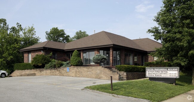
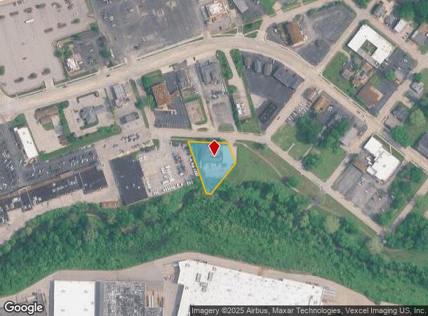
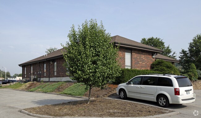
520 Center St, Fenton, MO 63026

NEARBY LISTINGS FOR SALE OR LEASE
Property Detail
520 Center St
St. Louis, MO-IL
Center St. Park
28O-32-0504
CENTER ST. PARK LOT B
Medicalbuilding
St. Louis
AE
Missouri
29099C0050F
b
2024
0.67 AC
2025
Fenton
221423
St. Louis
4,380 SF
DEMOGRAPHICS near 520 Center St
1 Mile
3 Mile
5 Mile
2024 Total Population
1,820
39,074
130,533
2029 Population
1,808
39,212
129,346
Pop Growth 2024-2029
(0.66%)
+ 0.35%
(0.91%)
Average Age
42
43
43
2024 Total Households
753
15,281
53,784
HH Growth 2024-2029
(0.66%)
+ 0.54%
(0.95%)
Median Household Inc
$87,874
$83,380
$84,255
Avg Household Size
2.40
2.50
2.40
2024 Avg HH Vehicles
2.00
2.00
2.00
Median Home Value
$322,549
$290,152
$281,968
Median Year Built
1985
1984
1977
Nearby Places
Map Layers
Map Styles
 Street
 Aerial
- Restaurants
- Banks
- Shops
- Fitness
- Groceries
PUBLIC TRANSPORTATION
COMMUTER RAIL
DRIVE
WALK
Distance
15 min
8.5 mi
AIRPORT
St Louis Lambert International
DRIVE
WALK
Distance
St Louis Lambert International
37 min
23.7 mi
Scott AFB/Midamerica St Louis
DRIVE
WALK
Distance
Scott AFB/Midamerica St Louis
62 min
44.4 mi
Nearby Properties
Address
Land Use
TOTAL SIZE
Lot Size
Zoning
Address
Land Use
TOTAL SIZE
Lot Size
Zoning
429,212 SF
53.13 AC
C-8
Address
Land Use
TOTAL SIZE
Lot Size
Zoning
862,067 SF
40.98 AC
C-8
Address
Land Use
TOTAL SIZE
Lot Size
Zoning
851,923 SF
32.28 AC
101PDMXD
Address
Land Use
TOTAL SIZE
Lot Size
Zoning
256,956 SF
23.68 AC
21IP-1
Address
Land Use
TOTAL SIZE
Lot Size
Zoning
62.50 AC
NU
Address
Land Use
TOTAL SIZE
Lot Size
Zoning
534,280 SF
23.37 AC
21IP-1
Address
Land Use
TOTAL SIZE
Lot Size
Zoning
105.49 AC
Address
Land Use
TOTAL SIZE
Lot Size
Zoning
460,421 SF
34.91 AC
21BP-2
Address
Land Use
TOTAL SIZE
Lot Size
Zoning
5,040 SF
53.51 AC
101R-1
Address
Land Use
TOTAL SIZE
Lot Size
Zoning
194,252 SF
10.66 AC
21IP-1
Address
Land Use
TOTAL SIZE
Lot Size
Zoning
139,212 SF
15.58 AC
21C-1
Address
Land Use
TOTAL SIZE
Lot Size
Zoning
112,840 SF
0.54 AC
C-8
Address
Land Use
TOTAL SIZE
Lot Size
Zoning
159,696 SF
10.52 AC
21IP-1
Address
Land Use
TOTAL SIZE
Lot Size
Zoning
157,584 SF
13.60 AC
21IP-1
Address
Land Use
TOTAL SIZE
Lot Size
Zoning
10.41 AC
21IP-1
Address
Land Use
TOTAL SIZE
Lot Size
Zoning
26.56 AC
NU
Address
Land Use
TOTAL SIZE
Lot Size
Zoning
375,522 SF
42.58 AC
C-8
Address
Land Use
TOTAL SIZE
Lot Size
Zoning
148,800 SF
26.31 AC
21IP-1
Address
Land Use
TOTAL SIZE
Lot Size
Zoning
224,872 SF
34.78 AC
21BP-2
Address
Land Use
TOTAL SIZE
Lot Size
Zoning
154,844 SF
13.29 AC
21OT-3
Address
Land Use
TOTAL SIZE
Lot Size
Zoning
129,090 SF
17.78 AC
21C-1
Address
Land Use
TOTAL SIZE
Lot Size
Zoning
8.84 AC
21IP-1
Address
Land Use
TOTAL SIZE
Lot Size
Zoning
182,616 SF
15.86 AC
21IP-1
Address
Land Use
TOTAL SIZE
Lot Size
Zoning
211,612 SF
41.36 AC
PB
Address
Land Use
TOTAL SIZE
Lot Size
Zoning
9.63 AC
21IP-1
Address
Land Use
TOTAL SIZE
Lot Size
Zoning
65,702 SF
12.33 AC
21HP-1
Address
Land Use
TOTAL SIZE
Lot Size
Zoning
221,724 SF
21.98 AC
21OT-4
Address
Land Use
TOTAL SIZE
Lot Size
Zoning
169,296 SF
11.93 AC
21IP-1
Address
Land Use
TOTAL SIZE
Lot Size
Zoning
91,465 SF
29.86 AC
21CP-1
Address
Land Use
TOTAL SIZE
Lot Size
Zoning
265,291 SF
14.91 AC
PR2
The World's #1 Commercial Real Estate Marketplace
Connect with us
© 2025 CoStar Group
The information above has been obtained from sources believed reliable. While we do not doubt its accuracy we have not verified it and make no guarantee, warranty or representation about it. It is your responsibility to independently confirm its accuracy and completeness. Any projections, opinions, assumptions, or estimates used are for example only and do not represent the current or future performance of the property. The value of this transaction to you depends on tax and other factors which should be evaluated by your tax, financial, and legal advisors. You and your advisors should conduct a careful, independent investigation of the property to determine to your satisfaction the suitability of the property for your needs.