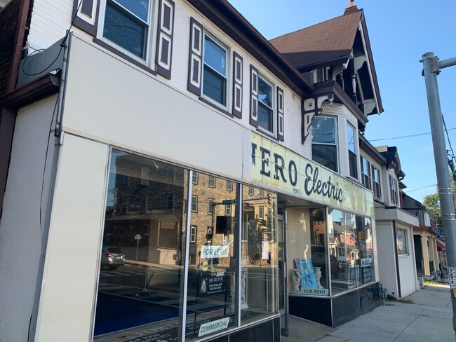
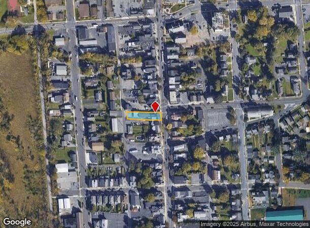
Property Record
520 Main St, Hellertown, PA 18055
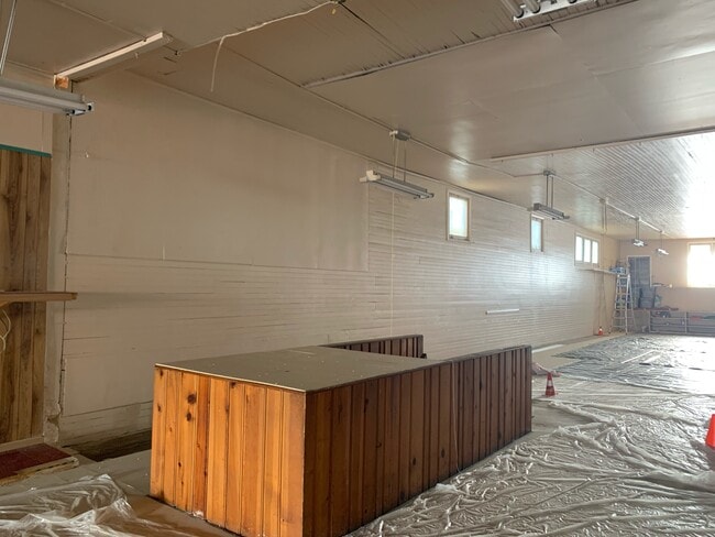
Current Lease Availabilities
NEARBY LISTINGS FOR SALE OR LEASE
Property Detail
520 Main St
Storesoffices
Northampton
X
Pennsylvania
42095C0329E
0.21 AC
2025
Lehigh Valley
2025
Philadelphia
017902
Allentown-Bethlehem-Easton, PA-NJ
8,228 SF
Q7SW3A 2 2 0715
DEMOGRAPHICS near 520 Main St
1 Mile
3 Mile
5 Mile
2024 Total Population
8,339
33,767
108,369
2029 Population
8,395
33,917
108,829
Pop Growth 2024-2029
+ 0.67%
+ 0.44%
+ 0.42%
Average Age
43
37
40
2024 Total Households
3,479
11,356
41,202
HH Growth 2024-2029
+ 0.52%
+ 0.79%
+ 0.49%
Median Household Inc
$76,475
$67,434
$70,149
Avg Household Size
2.30
2.50
2.40
2024 Avg HH Vehicles
2.00
2.00
2.00
Median Home Value
$254,077
$274,833
$242,794
Median Year Built
1959
1956
1956
Nearby Places
- Restaurants
- Banks
- Shops
- Fitness
- Groceries
PUBLIC TRANSPORTATION
AIRPORT
Lehigh Valley International
DRIVE
WALK
Distance
Lehigh Valley International
22 min
10.3 mi
Freight Ports
Port of Philadelphia
DRIVE
WALK
Distance
Port of Philadelphia
80 min
49.4 mi
Nearby Properties
Address
Land Use
TOTAL SIZE
Lot Size
Zoning
Address
Land Use
TOTAL SIZE
Lot Size
Zoning
425,507 SF
52.58 AC
HI
Address
Land Use
TOTAL SIZE
Lot Size
Zoning
1,197,396 SF
57.03 AC
HI
Address
Land Use
TOTAL SIZE
Lot Size
Zoning
12,838 SF
36.50 AC
IP
Address
Land Use
TOTAL SIZE
Lot Size
Zoning
1,200,000 SF
107.27 AC
HI
Address
Land Use
TOTAL SIZE
Lot Size
Zoning
1,710,800 SF
68.08 AC
HI
Address
Land Use
TOTAL SIZE
Lot Size
Zoning
26,653 SF
13.51 AC
HI
Address
Land Use
TOTAL SIZE
Lot Size
Zoning
11,856 SF
454.48 AC
CM
Address
Land Use
TOTAL SIZE
Lot Size
Zoning
800,280 SF
18.20 AC
HI
Address
Land Use
TOTAL SIZE
Lot Size
Zoning
332,641 SF
2.27 AC
HI
Address
Land Use
TOTAL SIZE
Lot Size
Zoning
800,250 SF
40.07 AC
HI
Address
Land Use
TOTAL SIZE
Lot Size
Zoning
676,788 SF
39.39 AC
HI
Address
Land Use
TOTAL SIZE
Lot Size
Zoning
10,572 SF
54.17 AC
IP
Address
Land Use
TOTAL SIZE
Lot Size
Zoning
421,883 SF
34.66 AC
HI
Address
Land Use
TOTAL SIZE
Lot Size
Zoning
31,442 SF
9.87 AC
IP
Address
Land Use
TOTAL SIZE
Lot Size
Zoning
39,016 SF
17.40 AC
RG
Address
Land Use
TOTAL SIZE
Lot Size
Zoning
24,354 SF
11.16 AC
HI
Address
Land Use
TOTAL SIZE
Lot Size
Zoning
21,462 SF
255.01 AC
IP
Address
Land Use
TOTAL SIZE
Lot Size
Zoning
809,830 SF
21.93 AC
HI
Address
Land Use
TOTAL SIZE
Lot Size
Zoning
5,578 SF
11.80 AC
R-2
Address
Land Use
TOTAL SIZE
Lot Size
Zoning
20,000 SF
2.81 AC
HI
Address
Land Use
TOTAL SIZE
Lot Size
Zoning
536,726 SF
12.02 AC
HI
Address
Land Use
TOTAL SIZE
Lot Size
Zoning
75,833 SF
10.64 AC
IP
Address
Land Use
TOTAL SIZE
Lot Size
Zoning
508,842 SF
26.64 AC
HI
Address
Land Use
TOTAL SIZE
Lot Size
Zoning
45.04 AC
HI
Address
Land Use
TOTAL SIZE
Lot Size
Zoning
53.47 AC
HI
Address
Land Use
TOTAL SIZE
Lot Size
Zoning
2,088 SF
98.89 AC
OSR
Address
Land Use
TOTAL SIZE
Lot Size
Zoning
182,845 SF
12.09 AC
HI
Address
Land Use
TOTAL SIZE
Lot Size
Zoning
2,320 SF
34.53 AC
RM
Address
Land Use
TOTAL SIZE
Lot Size
Zoning
151,013 SF
104.20 AC
R12
Address
Land Use
TOTAL SIZE
Lot Size
Zoning
246,960 SF
17.02 AC
HI
The World's #1 Commercial Real Estate Marketplace
Connect with us
© 2025 CoStar Group
The information above has been obtained from sources believed reliable. While we do not doubt its accuracy we have not verified it and make no guarantee, warranty or representation about it. It is your responsibility to independently confirm its accuracy and completeness. Any projections, opinions, assumptions, or estimates used are for example only and do not represent the current or future performance of the property. The value of this transaction to you depends on tax and other factors which should be evaluated by your tax, financial, and legal advisors. You and your advisors should conduct a careful, independent investigation of the property to determine to your satisfaction the suitability of the property for your needs.