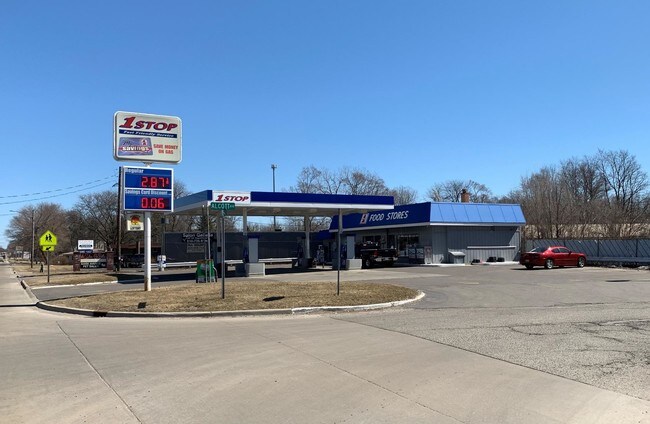
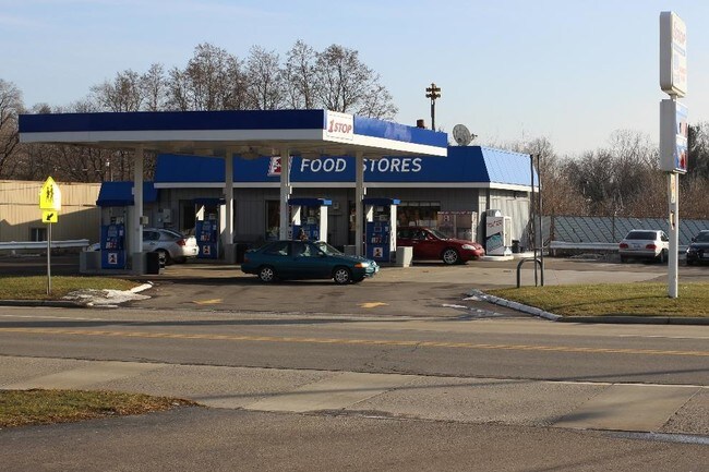
Property Record
5216 Richfield Rd, Flint, MI 48506

Save to a Folder
{{folder.Name}}
{{folder.ListingIds.length}} Properties
{{folder.ListingIds.length}} Property
Create a New Folder
Property Detail
5216 Richfield Rd
11-35-553-004
LOT 5 MACS SUB
Commercialnec
Genesee
C-2 HWY CO
Michigan
B and X Area of moderate flood hazard, usually the area between the limits of the 100-year and 500-year floods.
5
2025
0.62 AC
2025
Flint
012008
Detroit
1,501 SF
Flint, MI
NEARBY LISTINGS FOR SALE OR LEASE
DEMOGRAPHICS near 5216 Richfield Rd
1 mile
3 mile
5 mile
2025 Total Population
3,406
29,897
91,706
2030 Population
3,312
29,684
92,266
Pop Growth 2025-2030
(2.76%)
(0.71%)
+ 0.61%
Average Age
43
41
40
2025 Total Households
1,410
12,208
38,710
HH Growth 2025-2030
(2.84%)
(0.78%)
+ 0.51%
Median Household Inc
$65,804
$55,299
$47,156
Avg Household Size
2.40
2.40
2.30
2025 Avg HH Vehicles
2.00
2.00
2.00
Median Home Value
$151,687
$135,595
$134,898
Median Year Built
1958
1960
1964
Nearby Places
Map Layers
Map Styles
 Street
 Aerial
Layers
 Traffic
 Biking
Places
Listings with unknown addresses are not visible on the map
- Restaurants
- Banks
- Shops
- Fitness
- Groceries
PUBLIC TRANSPORTATION
AIRPORT
Bishop International
Drive
Walk
Distance
Bishop International
30 min
14.8 mi
SALE & LEASE HISTORY
LISTING DATE
SALE/LEASE

Apr 02, 2019
For Sale
Nearby Properties
Address
Land Use
TOTAL SIZE
Lot Size
Zoning
Address
Land Use
TOTAL SIZE
Lot Size
Zoning
MOBILE
Address
Land Use
TOTAL SIZE
Lot Size
Zoning
290,267 SF
79 AC
PC
Address
Land Use
TOTAL SIZE
Lot Size
Zoning
227,669 SF
25.87 AC
C-2
Address
Land Use
TOTAL SIZE
Lot Size
Zoning
354,079 SF
48.41 AC
C-4
Address
Land Use
TOTAL SIZE
Lot Size
Zoning
371,636 SF
12.50 AC
M-1
Address
Land Use
TOTAL SIZE
Lot Size
Zoning
2,400 SF
81 AC
R-4 MANUF
Address
Land Use
TOTAL SIZE
Lot Size
Zoning
111,882 SF
5.36 AC
C-4
Address
Land Use
TOTAL SIZE
Lot Size
Zoning
419,038 SF
57.18 AC
M-2
Address
Land Use
TOTAL SIZE
Lot Size
Zoning
136,506 SF
16.54 AC
C-4
Address
Land Use
TOTAL SIZE
Lot Size
Zoning
Address
Land Use
TOTAL SIZE
Lot Size
Zoning
218,229 SF
37.64 AC
CE
Address
Land Use
TOTAL SIZE
Lot Size
Zoning
107,580 SF
5.18 AC
RETAIL
Address
Land Use
TOTAL SIZE
Lot Size
Zoning
82,240 SF
15.03 AC
C-2
Address
Land Use
TOTAL SIZE
Lot Size
Zoning
192,900 SF
6.50 AC
CE
Address
Land Use
TOTAL SIZE
Lot Size
Zoning
118,210 SF
6.60 AC
CE
Address
Land Use
TOTAL SIZE
Lot Size
Zoning
14,336 SF
3.29 AC
NOT AVAILA
Address
Land Use
TOTAL SIZE
Lot Size
Zoning
72,720 SF
6.41 AC
C-2
Address
Land Use
TOTAL SIZE
Lot Size
Zoning
57.47 AC
R-4 MANUF
Address
Land Use
TOTAL SIZE
Lot Size
Zoning
726 SF
10.40 AC
R-4 MANUF
Address
Land Use
TOTAL SIZE
Lot Size
Zoning
19,744 SF
3.52 AC
C-2
Address
Land Use
TOTAL SIZE
Lot Size
Zoning
58,197 SF
11.90 AC
C-2
Address
Land Use
TOTAL SIZE
Lot Size
Zoning
43,751 SF
3.14 AC
TN-2
Address
Land Use
TOTAL SIZE
Lot Size
Zoning
70,312 SF
30.90 AC
M-1
Address
Land Use
TOTAL SIZE
Lot Size
Zoning
114,221 SF
6.16 AC
CC
Address
Land Use
TOTAL SIZE
Lot Size
Zoning
138,232 SF
16.84 AC
C-4
Address
Land Use
TOTAL SIZE
Lot Size
Zoning
60,925 SF
2.69 AC
M-1
Address
Land Use
TOTAL SIZE
Lot Size
Zoning
39,274 SF
20.76 AC
CE
Address
Land Use
TOTAL SIZE
Lot Size
Zoning
108,740 SF
5.56 AC
CE
Address
Land Use
TOTAL SIZE
Lot Size
Zoning
28,476 SF
3.39 AC
NC
Address
Land Use
TOTAL SIZE
Lot Size
Zoning
74,480 SF
3.73 AC
M-1
The World's #1 Commercial Real Estate Marketplace
Connect with us
© 2026 CoStar Group
The information above has been obtained from sources believed reliable. While we do not doubt its accuracy we have not verified it and make no guarantee, warranty or representation about it. It is your responsibility to independently confirm its accuracy and completeness. Any projections, opinions, assumptions, or estimates used are for example only and do not represent the current or future performance of the property. The value of this transaction to you depends on tax and other factors which should be evaluated by your tax, financial, and legal advisors. You and your advisors should conduct a careful, independent investigation of the property to determine to your satisfaction the suitability of the property for your needs.