Property Record
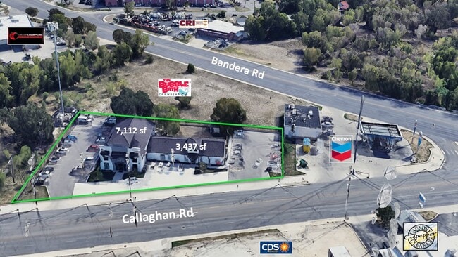
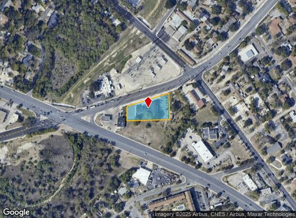
5250 Callaghan Rd, San Antonio, TX 78228
NEARBY LISTINGS FOR SALE OR LEASE
Property Detail
5250 Callaghan Rd
San Antonio-New Braunfels, TX
Block 2077
11544-001-0990
NCB 11544 BLK E LOT S IRR 184.84 FT OF 99 (SW KOREAN BAPTIST CHURCH) 2016-UPDATED LEGAL DESCRIPTION & ACREAGE PER 17563/222 (.049 AC WENT TO STREET). JF/GIS/2-2-16.
Officebuilding
Bexar
X
Texas
48029C0380G
99
2024
0.97 AC
2025
Northwest
180604
San Antonio
11,590 SF
DEMOGRAPHICS near 5250 Callaghan Rd
1 Mile
3 Mile
5 Mile
2024 Total Population
12,614
132,488
370,148
2029 Population
13,329
140,592
391,829
Pop Growth 2024-2029
+ 5.67%
+ 6.12%
+ 5.86%
Average Age
39
38
37
2024 Total Households
5,037
54,112
144,533
HH Growth 2024-2029
+ 6.00%
+ 6.42%
+ 6.14%
Median Household Inc
$42,918
$45,001
$47,677
Avg Household Size
2.40
2.40
2.50
2024 Avg HH Vehicles
2.00
2.00
2.00
Median Home Value
$167,377
$163,022
$168,260
Median Year Built
1973
1977
1977
Nearby Places
Map Layers
Map Styles
 Street
 Aerial
- Restaurants
- Banks
- Shops
- Fitness
- Groceries
PUBLIC TRANSPORTATION
COMMUTER RAIL
San Antonio Amtrak Station (Sunset Limited - Amtrak, Texas Eagle - Amtrak)
DRIVE
WALK
Distance
San Antonio Amtrak Station (Sunset Limited - Amtrak, Texas Eagle - Amtrak)
15 min
8.6 mi
AIRPORT
San Antonio International
DRIVE
WALK
Distance
San Antonio International
11 min
8.1 mi
Freight Ports
Calhoun Port
DRIVE
WALK
Distance
Calhoun Port
192 min
156.0 mi
SALE & LEASE HISTORY
LISTING DATE
SALE/LEASE

Sep 23, 2016
For Sale
Nearby Properties
Address
Land Use
TOTAL SIZE
Lot Size
Zoning
Address
Land Use
TOTAL SIZE
Lot Size
Zoning
1,414,945 SF
16.77 AC
Address
Land Use
TOTAL SIZE
Lot Size
Zoning
429,561 SF
25.70 AC
Address
Land Use
TOTAL SIZE
Lot Size
Zoning
370,870 SF
27.27 AC
Address
Land Use
TOTAL SIZE
Lot Size
Zoning
541,776 SF
22.15 AC
Address
Land Use
TOTAL SIZE
Lot Size
Zoning
97.47 AC
Address
Land Use
TOTAL SIZE
Lot Size
Zoning
278,352 SF
10 AC
Address
Land Use
TOTAL SIZE
Lot Size
Zoning
301,817 SF
12.22 AC
Address
Land Use
TOTAL SIZE
Lot Size
Zoning
326,820 SF
12.57 AC
Address
Land Use
TOTAL SIZE
Lot Size
Zoning
284,359 SF
21.53 AC
Address
Land Use
TOTAL SIZE
Lot Size
Zoning
227,744 SF
3.99 AC
Address
Land Use
TOTAL SIZE
Lot Size
Zoning
239,623 SF
26.63 AC
Address
Land Use
TOTAL SIZE
Lot Size
Zoning
213,968 SF
21.30 AC
Address
Land Use
TOTAL SIZE
Lot Size
Zoning
253,862 SF
14.78 AC
Address
Land Use
TOTAL SIZE
Lot Size
Zoning
495,484 SF
5.81 AC
Address
Land Use
TOTAL SIZE
Lot Size
Zoning
61.64 AC
Address
Land Use
TOTAL SIZE
Lot Size
Zoning
264,676 SF
11.91 AC
Address
Land Use
TOTAL SIZE
Lot Size
Zoning
259,934 SF
9.81 AC
Address
Land Use
TOTAL SIZE
Lot Size
Zoning
285,150 SF
13.62 AC
Address
Land Use
TOTAL SIZE
Lot Size
Zoning
340,653 SF
19.27 AC
Address
Land Use
TOTAL SIZE
Lot Size
Zoning
8,508 SF
3.34 AC
Address
Land Use
TOTAL SIZE
Lot Size
Zoning
243,251 SF
10 AC
Address
Land Use
TOTAL SIZE
Lot Size
Zoning
221,778 SF
16.31 AC
Address
Land Use
TOTAL SIZE
Lot Size
Zoning
536,162 SF
25.11 AC
Address
Land Use
TOTAL SIZE
Lot Size
Zoning
272,456 SF
21.53 AC
Address
Land Use
TOTAL SIZE
Lot Size
Zoning
63.25 AC
Address
Land Use
TOTAL SIZE
Lot Size
Zoning
299,088 SF
15.66 AC
Address
Land Use
TOTAL SIZE
Lot Size
Zoning
232,398 SF
12.66 AC
Address
Land Use
TOTAL SIZE
Lot Size
Zoning
291,385 SF
16.19 AC
Address
Land Use
TOTAL SIZE
Lot Size
Zoning
388,553 SF
29 AC
Address
Land Use
TOTAL SIZE
Lot Size
Zoning
137,036 SF
4.73 AC
The World's #1 Commercial Real Estate Marketplace
Connect with us
© 2026 CoStar Group
The information above has been obtained from sources believed reliable. While we do not doubt its accuracy we have not verified it and make no guarantee, warranty or representation about it. It is your responsibility to independently confirm its accuracy and completeness. Any projections, opinions, assumptions, or estimates used are for example only and do not represent the current or future performance of the property. The value of this transaction to you depends on tax and other factors which should be evaluated by your tax, financial, and legal advisors. You and your advisors should conduct a careful, independent investigation of the property to determine to your satisfaction the suitability of the property for your needs.