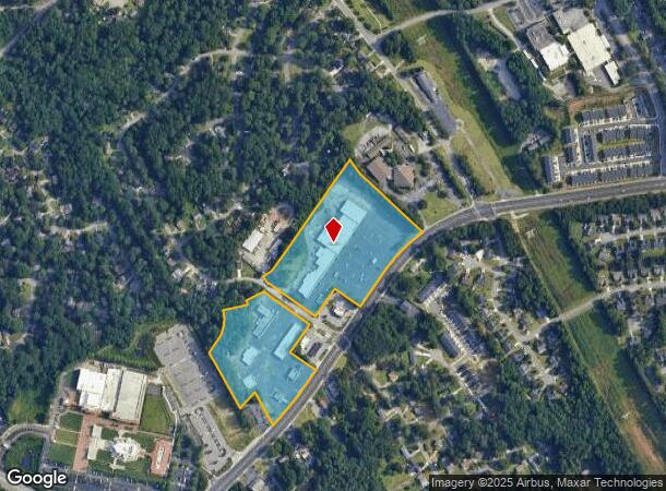
Property Record
5385 Lawrenceville Hwy Nw, Lilburn, GA 30047

Current Lease Availabilities
NEARBY LISTINGS FOR SALE OR LEASE
Property Detail
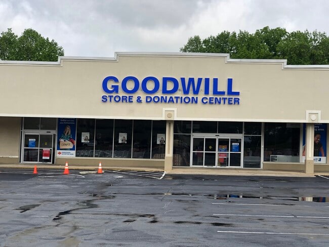
5385 Lawrenceville Hwy Nw
6-146-062
U S HWY 29
Regionalshoppingcenterormallwithanchorstore
Gwinnett
X
Georgia
13135C0112F
146
2025
16.26 AC
2025
Norcross/Peachtree
050459
Atlanta
93,310 SF
Atlanta-Sandy Springs-Roswell, GA
DEMOGRAPHICS near 5385 Lawrenceville Hwy Nw
1 Mile
3 Mile
5 Mile
2024 Total Population
10,992
93,593
246,178
2029 Population
11,406
96,875
254,194
Pop Growth 2024-2029
+ 3.77%
+ 3.51%
+ 3.26%
Average Age
36
36
36
2024 Total Households
3,299
30,519
84,817
HH Growth 2024-2029
+ 3.94%
+ 3.46%
+ 3.15%
Median Household Inc
$56,666
$55,887
$56,865
Avg Household Size
3.20
3.00
2.80
2024 Avg HH Vehicles
2.00
2.00
2.00
Median Home Value
$233,086
$263,875
$281,879
Median Year Built
1986
1986
1986
Nearby Places
Map Layers
Map Styles
 Street
 Aerial
- Restaurants
- Banks
- Shops
- Fitness
- Groceries
PUBLIC TRANSPORTATION
AIRPORT
Hartsfield - Jackson Atlanta International
DRIVE
WALK
Distance
Hartsfield - Jackson Atlanta International
43 min
29.3 mi
Nearby Properties
Address
Land Use
TOTAL SIZE
Lot Size
Zoning
Address
Land Use
TOTAL SIZE
Lot Size
Zoning
709,399 SF
59.34 AC
RM13
Address
Land Use
TOTAL SIZE
Lot Size
Zoning
338,670 SF
28.61 AC
RM
Address
Land Use
TOTAL SIZE
Lot Size
Zoning
483,912 SF
43.10 AC
OI
Address
Land Use
TOTAL SIZE
Lot Size
Zoning
525,526 SF
80.61 AC
RA200
Address
Land Use
TOTAL SIZE
Lot Size
Zoning
273,492 SF
23.08 AC
RM
Address
Land Use
TOTAL SIZE
Lot Size
Zoning
285,440 SF
24.68 AC
RM
Address
Land Use
TOTAL SIZE
Lot Size
Zoning
413,878 SF
29.13 AC
CB
Address
Land Use
TOTAL SIZE
Lot Size
Zoning
321,956 SF
26.87 AC
RM13
Address
Land Use
TOTAL SIZE
Lot Size
Zoning
455,471 SF
48.23 AC
R75
Address
Land Use
TOTAL SIZE
Lot Size
Zoning
334,795 SF
42.50 AC
RM13
Address
Land Use
TOTAL SIZE
Lot Size
Zoning
257,050 SF
26.17 AC
RM13
Address
Land Use
TOTAL SIZE
Lot Size
Zoning
321,756 SF
26.28 AC
RM
Address
Land Use
TOTAL SIZE
Lot Size
Zoning
356,488 SF
33 AC
RM10
Address
Land Use
TOTAL SIZE
Lot Size
Zoning
284,236 SF
22.25 AC
RM100
Address
Land Use
TOTAL SIZE
Lot Size
Zoning
285,384 SF
21.32 AC
RM
Address
Land Use
TOTAL SIZE
Lot Size
Zoning
287,502 SF
43.15 AC
R1
Address
Land Use
TOTAL SIZE
Lot Size
Zoning
276,262 SF
22.17 AC
RM13
Address
Land Use
TOTAL SIZE
Lot Size
Zoning
367,517 SF
34.61 AC
RM13
Address
Land Use
TOTAL SIZE
Lot Size
Zoning
245,165 SF
16.66 AC
RA200
Address
Land Use
TOTAL SIZE
Lot Size
Zoning
283,958 SF
23.75 AC
RM13
Address
Land Use
TOTAL SIZE
Lot Size
Zoning
225,939 SF
19.79 AC
RM13
Address
Land Use
TOTAL SIZE
Lot Size
Zoning
353,094 SF
23.33 AC
RM
Address
Land Use
TOTAL SIZE
Lot Size
Zoning
244,131 SF
32.59 AC
RM8
Address
Land Use
TOTAL SIZE
Lot Size
Zoning
172,197 SF
18.03 AC
RM10
Address
Land Use
TOTAL SIZE
Lot Size
Zoning
241,314 SF
20.22 AC
RM10
Address
Land Use
TOTAL SIZE
Lot Size
Zoning
188,118 SF
13.87 AC
RM13
Address
Land Use
TOTAL SIZE
Lot Size
Zoning
174,905 SF
35.72 AC
R1
Address
Land Use
TOTAL SIZE
Lot Size
Zoning
253,672 SF
15.07 AC
M1
Address
Land Use
TOTAL SIZE
Lot Size
Zoning
195,253 SF
21.87 AC
R100
Address
Land Use
TOTAL SIZE
Lot Size
Zoning
186,325 SF
17.24 AC
RM13
The World's #1 Commercial Real Estate Marketplace
Connect with us
© 2026 CoStar Group
The information above has been obtained from sources believed reliable. While we do not doubt its accuracy we have not verified it and make no guarantee, warranty or representation about it. It is your responsibility to independently confirm its accuracy and completeness. Any projections, opinions, assumptions, or estimates used are for example only and do not represent the current or future performance of the property. The value of this transaction to you depends on tax and other factors which should be evaluated by your tax, financial, and legal advisors. You and your advisors should conduct a careful, independent investigation of the property to determine to your satisfaction the suitability of the property for your needs.