Property Record
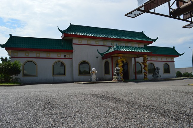
5285 Highway 90 W, Mobile, AL 36619


Property Detail
5285 Highway 90 W
Mobile, AL
PART OF LOT 1 RANGELINE 90 S/D UNIT ONE (REVISED) RESUB OF LOT 6 RESUB OF PARCEL 6A & 6B MBK 113/83 BEG AT TH NW COR OF SD
33-05-38-0-004-004.006
Mobile
Restaurantbuilding
Alabama
B and X Area of moderate flood hazard, usually the area between the limits of the 100-year and 500-year floods.
1,6
2025
1.25 AC
2025
Outlying Mobile County
006802
Mobile
6,646 SF
NEARBY LISTINGS FOR SALE OR LEASE
DEMOGRAPHICS near 5285 Highway 90 W
1 mile
3 mile
5 mile
2024 Total Population
2,959
30,363
93,172
2029 Population
2,960
30,052
91,781
Pop Growth 2024-2029
+ 0.03%
(1.02%)
(1.49%)
Average Age
41
42
40
2024 Total Households
1,188
12,372
38,317
HH Growth 2024-2029
(0.08%)
(1.06%)
(1.57%)
Median Household Inc
$49,953
$61,294
$58,653
Avg Household Size
2.30
2.40
2.40
2024 Avg HH Vehicles
2.00
2.00
2.00
Median Home Value
$158,043
$202,938
$209,982
Median Year Built
1978
1980
1982
Nearby Places
Map Layers
Map Styles
 Street
 Aerial
Transit
 Traffic
 Biking
Places
Listings with unknown addresses are not visible on the map
- Restaurants
- Banks
- Shops
- Fitness
- Groceries
PUBLIC TRANSPORTATION
AIRPORT
Mobile International
Drive
Walk
Distance
Mobile International
14 min
8.4 mi
Mobile Regional
Drive
Walk
Distance
Mobile Regional
24 min
11.5 mi
Freight Ports
Port of Mobile
Drive
Walk
Distance
Port of Mobile
17 min
11.8 mi
SALE & LEASE HISTORY
LISTING DATE
SALE/LEASE

Sep 24, 2016
For Sale
Jan 03, 2024
For Sale
Apr 06, 2021
For Sale
Nearby Properties
Address
Land Use
TOTAL SIZE
Lot Size
Zoning
Address
Land Use
TOTAL SIZE
Lot Size
Zoning
85,823 SF
13.26 AC
Address
Land Use
TOTAL SIZE
Lot Size
Zoning
117,000 SF
Address
Land Use
TOTAL SIZE
Lot Size
Zoning
24,255 SF
9.15 AC
Address
Land Use
TOTAL SIZE
Lot Size
Zoning
7,810 SF
15.35 AC
Address
Land Use
TOTAL SIZE
Lot Size
Zoning
37,604 SF
9.10 AC
Address
Land Use
TOTAL SIZE
Lot Size
Zoning
78,750 SF
27.51 AC
Address
Land Use
TOTAL SIZE
Lot Size
Zoning
26,933 SF
82.37 AC
Address
Land Use
TOTAL SIZE
Lot Size
Zoning
18,392 SF
15.69 AC
Address
Land Use
TOTAL SIZE
Lot Size
Zoning
204,868 SF
22.14 AC
Address
Land Use
TOTAL SIZE
Lot Size
Zoning
27,580 SF
4.69 AC
Address
Land Use
TOTAL SIZE
Lot Size
Zoning
51,610 SF
16.89 AC
Address
Land Use
TOTAL SIZE
Lot Size
Zoning
15,476 SF
10.44 AC
Address
Land Use
TOTAL SIZE
Lot Size
Zoning
78,750 SF
24 AC
Address
Land Use
TOTAL SIZE
Lot Size
Zoning
20,000 SF
28.80 AC
Address
Land Use
TOTAL SIZE
Lot Size
Zoning
139,097 SF
11.64 AC
Address
Land Use
TOTAL SIZE
Lot Size
Zoning
66,382 SF
1.71 AC
Address
Land Use
TOTAL SIZE
Lot Size
Zoning
99,076 SF
25 AC
Address
Land Use
TOTAL SIZE
Lot Size
Zoning
110,982 SF
17.46 AC
Address
Land Use
TOTAL SIZE
Lot Size
Zoning
6,880 SF
12.77 AC
Address
Land Use
TOTAL SIZE
Lot Size
Zoning
92,271 SF
15.40 AC
Address
Land Use
TOTAL SIZE
Lot Size
Zoning
6,880 SF
12.74 AC
Address
Land Use
TOTAL SIZE
Lot Size
Zoning
94,116 SF
7.11 AC
Address
Land Use
TOTAL SIZE
Lot Size
Zoning
396.69 AC
Address
Land Use
TOTAL SIZE
Lot Size
Zoning
16,452 SF
4.32 AC
Address
Land Use
TOTAL SIZE
Lot Size
Zoning
21,143 SF
7.03 AC
Address
Land Use
TOTAL SIZE
Lot Size
Zoning
74,000 SF
3.46 AC
Address
Land Use
TOTAL SIZE
Lot Size
Zoning
76,560 SF
27.88 AC
Address
Land Use
TOTAL SIZE
Lot Size
Zoning
60,630 SF
6.70 AC
Address
Land Use
TOTAL SIZE
Lot Size
Zoning
58,306 SF
3.11 AC
Address
Land Use
TOTAL SIZE
Lot Size
Zoning
11,108 SF
5.43 AC
The World's #1 Commercial Real Estate Marketplace
Connect with us
© 2026 CoStar Group
The information above has been obtained from sources believed reliable. While we do not doubt its accuracy we have not verified it and make no guarantee, warranty or representation about it. It is your responsibility to independently confirm its accuracy and completeness. Any projections, opinions, assumptions, or estimates used are for example only and do not represent the current or future performance of the property. The value of this transaction to you depends on tax and other factors which should be evaluated by your tax, financial, and legal advisors. You and your advisors should conduct a careful, independent investigation of the property to determine to your satisfaction the suitability of the property for your needs.