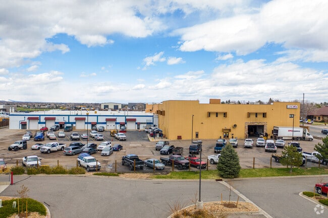
Property Record
5293 Ward Rd, Arvada, CO 80002
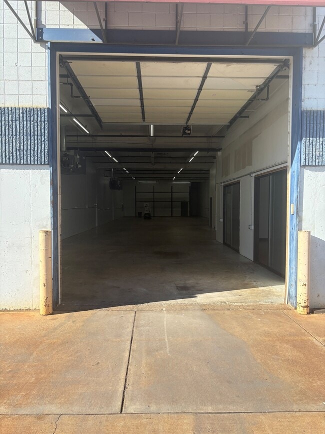

Current Lease Availabilities
Property Detail
5293 Ward Rd
39-172-03-018
SECTION 17 TOWNSHIP 03 RANGE 69 QTR NW SUBDIVISIONCD 795405 SUBDIVISIONNAME WARD ROAD INDUSTRIAL CONDOS BLOCK LOT 0008 TRACT
Industrialcondominium
JEFFERSON
PD
Colorado
B and X Area of moderate flood hazard, usually the area between the limits of the 100-year and 500-year floods.
8
2023
0.14 AC
2024
West Denver
009852
Denver
6,035 SF
Denver-Aurora-Centennial, CO
NEARBY LISTINGS FOR SALE OR LEASE
DEMOGRAPHICS near 5293 Ward Rd
1 mile
3 mile
5 mile
2025 Total Population
6,745
82,785
213,538
2030 Population
6,874
82,615
212,935
Pop Growth 2025-2030
+ 1.91%
(0.21%)
(0.28%)
Average Age
42
43
42
2025 Total Households
2,857
34,576
89,114
HH Growth 2025-2030
+ 1.96%
(0.27%)
(0.30%)
Median Household Inc
$122,206
$105,529
$99,804
Avg Household Size
2.30
2.30
2.30
2025 Avg HH Vehicles
2.00
2.00
2.00
Median Home Value
$737,778
$721,209
$702,346
Median Year Built
1998
1976
1975
Nearby Places
Map Layers
Map Styles
 Street
 Aerial
Transit
 Traffic
 Biking
Places
Listings with unknown addresses are not visible on the map
- Restaurants
- Banks
- Shops
- Fitness
- Groceries
PUBLIC TRANSPORTATION
COMMUTER RAIL
Drive
Walk
Distance
3 min
13 min
0.7 mi
Drive
Walk
Distance
5 min
1.8 mi
AIRPORT
Denver International
Drive
Walk
Distance
Denver International
41 min
31.6 mi
Nearby Properties
Address
Land Use
TOTAL SIZE
Lot Size
Zoning
Address
Land Use
TOTAL SIZE
Lot Size
Zoning
830,160 SF
26.93 AC
Address
Land Use
TOTAL SIZE
Lot Size
Zoning
269,013 SF
31.89 AC
Address
Land Use
TOTAL SIZE
Lot Size
Zoning
187,095 SF
23.42 AC
Address
Land Use
TOTAL SIZE
Lot Size
Zoning
187,745 SF
16.25 AC
Address
Land Use
TOTAL SIZE
Lot Size
Zoning
353,286 SF
14.49 AC
Address
Land Use
TOTAL SIZE
Lot Size
Zoning
227,132 SF
11.95 AC
Address
Land Use
TOTAL SIZE
Lot Size
Zoning
365,230 SF
12.51 AC
Address
Land Use
TOTAL SIZE
Lot Size
Zoning
389,561 SF
10.73 AC
Address
Land Use
TOTAL SIZE
Lot Size
Zoning
192,500 SF
10.97 AC
Address
Land Use
TOTAL SIZE
Lot Size
Zoning
260,325 SF
13.70 AC
Address
Land Use
TOTAL SIZE
Lot Size
Zoning
215,878 SF
11.82 AC
A2
Address
Land Use
TOTAL SIZE
Lot Size
Zoning
131,135 SF
2.83 AC
Address
Land Use
TOTAL SIZE
Lot Size
Zoning
262,699 SF
13.10 AC
A2
Address
Land Use
TOTAL SIZE
Lot Size
Zoning
363,989 SF
30.10 AC
Address
Land Use
TOTAL SIZE
Lot Size
Zoning
101,761 SF
4.34 AC
Address
Land Use
TOTAL SIZE
Lot Size
Zoning
142,200 SF
9.82 AC
Address
Land Use
TOTAL SIZE
Lot Size
Zoning
520,896 SF
24.42 AC
I1
Address
Land Use
TOTAL SIZE
Lot Size
Zoning
125,884 SF
8.88 AC
Address
Land Use
TOTAL SIZE
Lot Size
Zoning
91,734 SF
9.69 AC
Address
Land Use
TOTAL SIZE
Lot Size
Zoning
109,401 SF
12.19 AC
Address
Land Use
TOTAL SIZE
Lot Size
Zoning
130,662 SF
9.67 AC
Address
Land Use
TOTAL SIZE
Lot Size
Zoning
223,338 SF
9.42 AC
I1
Address
Land Use
TOTAL SIZE
Lot Size
Zoning
149,760 SF
8.64 AC
Address
Land Use
TOTAL SIZE
Lot Size
Zoning
64,883 SF
4.74 AC
Address
Land Use
TOTAL SIZE
Lot Size
Zoning
82,055 SF
19.39 AC
Address
Land Use
TOTAL SIZE
Lot Size
Zoning
78,494 SF
5.68 AC
Address
Land Use
TOTAL SIZE
Lot Size
Zoning
174,853 SF
14.68 AC
Address
Land Use
TOTAL SIZE
Lot Size
Zoning
67,520 SF
6.46 AC
Address
Land Use
TOTAL SIZE
Lot Size
Zoning
51,987 SF
15.23 AC
PD
Address
Land Use
TOTAL SIZE
Lot Size
Zoning
83,684 SF
8.15 AC
The World's #1 Commercial Real Estate Marketplace
Connect with us
© 2026 CoStar Group
The information above has been obtained from sources believed reliable. While we do not doubt its accuracy we have not verified it and make no guarantee, warranty or representation about it. It is your responsibility to independently confirm its accuracy and completeness. Any projections, opinions, assumptions, or estimates used are for example only and do not represent the current or future performance of the property. The value of this transaction to you depends on tax and other factors which should be evaluated by your tax, financial, and legal advisors. You and your advisors should conduct a careful, independent investigation of the property to determine to your satisfaction the suitability of the property for your needs.