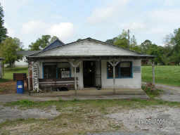
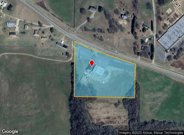
Property Record
5335 Highway 53 W, Jasper, GA 30143
NEARBY LISTINGS FOR SALE OR LEASE
-
-
View all Jasper listings for sale on LoopNet.com
Property Detail
5335 Highway 53 W
031-000-068-000
Mt Hope Community Baptist Chur
Religious
DIST12 LL126 TRACT1 7.15 AC CHURCH
X
Pickens
13057C0050E
Georgia
0
7.15 AC
2025
Pickens County
050400
Atlanta
3,040 SF
Atlanta-Sandy Springs-Roswell, GA
DEMOGRAPHICS near 5335 Highway 53 W
1 Mile
3 Mile
5 Mile
2024 Total Population
434
4,169
13,562
2029 Population
487
4,679
15,262
Pop Growth 2024-2029
+ 12.21%
+ 12.23%
+ 12.54%
Average Age
42
41
41
2024 Total Households
156
1,492
4,967
HH Growth 2024-2029
+ 12.18%
+ 12.06%
+ 12.30%
Median Household Inc
$67,142
$67,658
$66,953
Avg Household Size
2.60
2.70
2.60
2024 Avg HH Vehicles
2.00
2.00
2.00
Median Home Value
$252,857
$245,774
$234,083
Median Year Built
1996
1996
1995
Nearby Places
Map Layers
Map Styles
 Street
 Aerial
- Restaurants
- Banks
- Shops
- Fitness
- Groceries
Nearby Properties
Address
Land Use
TOTAL SIZE
Lot Size
Zoning
Address
Land Use
TOTAL SIZE
Lot Size
Zoning
74,652 SF
31.20 AC
HB
Address
Land Use
TOTAL SIZE
Lot Size
Zoning
18,600 SF
3.11 AC
C-2
Address
Land Use
TOTAL SIZE
Lot Size
Zoning
15,000 SF
8.70 AC
HB
Address
Land Use
TOTAL SIZE
Lot Size
Zoning
27 AC
R-A
Address
Land Use
TOTAL SIZE
Lot Size
Zoning
7,140 SF
22.50 AC
HB
Address
Land Use
TOTAL SIZE
Lot Size
Zoning
153.92 AC
RR
Address
Land Use
TOTAL SIZE
Lot Size
Zoning
24,000 SF
3.51 AC
C-2
Address
Land Use
TOTAL SIZE
Lot Size
Zoning
313.50 AC
C-2
Address
Land Use
TOTAL SIZE
Lot Size
Zoning
8,150 SF
6 AC
R-1
Address
Land Use
TOTAL SIZE
Lot Size
Zoning
8,000 SF
0.60 AC
C-2
Address
Land Use
TOTAL SIZE
Lot Size
Zoning
69.50 AC
C-2
Address
Land Use
TOTAL SIZE
Lot Size
Zoning
12,934 SF
5.20 AC
HB
Address
Land Use
TOTAL SIZE
Lot Size
Zoning
8,000 SF
0.60 AC
C-2
Address
Land Use
TOTAL SIZE
Lot Size
Zoning
5,520 SF
6 AC
AG
Address
Land Use
TOTAL SIZE
Lot Size
Zoning
40.60 AC
R-A
Address
Land Use
TOTAL SIZE
Lot Size
Zoning
26 AC
AG
Address
Land Use
TOTAL SIZE
Lot Size
Zoning
158.61 AC
AG
Address
Land Use
TOTAL SIZE
Lot Size
Zoning
8,200 SF
0.61 AC
C-2
Address
Land Use
TOTAL SIZE
Lot Size
Zoning
8,000 SF
0.61 AC
C-2
Address
Land Use
TOTAL SIZE
Lot Size
Zoning
8,000 SF
0.59 AC
C-2
Address
Land Use
TOTAL SIZE
Lot Size
Zoning
8,200 SF
0.60 AC
C-2
Address
Land Use
TOTAL SIZE
Lot Size
Zoning
185.58 AC
C-2
Address
Land Use
TOTAL SIZE
Lot Size
Zoning
424.12 AC
AG
Address
Land Use
TOTAL SIZE
Lot Size
Zoning
108.90 AC
NC
Address
Land Use
TOTAL SIZE
Lot Size
Zoning
86.72 AC
RR
Address
Land Use
TOTAL SIZE
Lot Size
Zoning
46.51 AC
HB
Address
Land Use
TOTAL SIZE
Lot Size
Zoning
164.87 AC
C-2
Address
Land Use
TOTAL SIZE
Lot Size
Zoning
2,400 SF
0.90 AC
C-2
Address
Land Use
TOTAL SIZE
Lot Size
Zoning
3,400 SF
1.16 AC
HB
The World's #1 Commercial Real Estate Marketplace
Connect with us
© 2026 CoStar Group
The information above has been obtained from sources believed reliable. While we do not doubt its accuracy we have not verified it and make no guarantee, warranty or representation about it. It is your responsibility to independently confirm its accuracy and completeness. Any projections, opinions, assumptions, or estimates used are for example only and do not represent the current or future performance of the property. The value of this transaction to you depends on tax and other factors which should be evaluated by your tax, financial, and legal advisors. You and your advisors should conduct a careful, independent investigation of the property to determine to your satisfaction the suitability of the property for your needs.