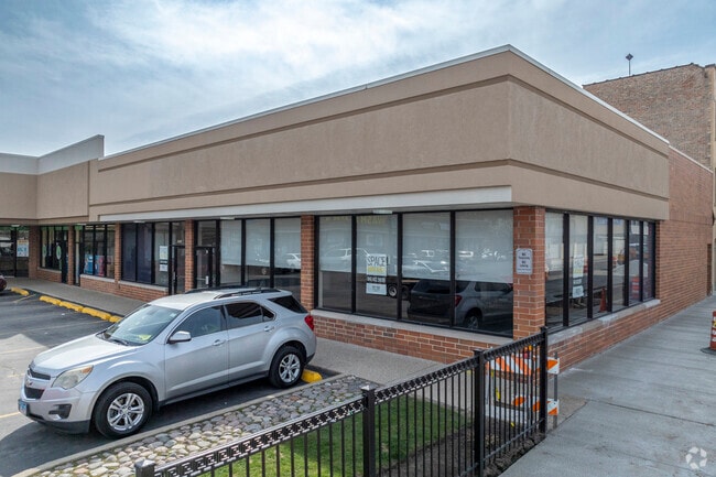
Property Record
5330 N Campbell Ave, Chicago, IL 60625

Current Lease Availabilities
NEARBY LISTINGS FOR SALE OR LEASE
Property Detail
5330 N Campbell Ave
Chicago
Brummel & Companys Lincoln
Chicago-Naperville-Elgin, IL-IN
Cook
13-12-225-005-0000
Illinois
Residentialnec
0.12 AC
X
Northwest City
17031C0402J
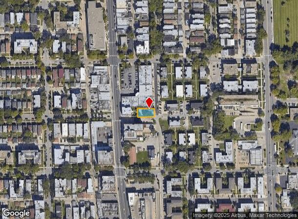
DEMOGRAPHICS near 5330 N Campbell Ave
1 Mile
3 Mile
5 Mile
2024 Total Population
47,057
469,449
947,812
2029 Population
45,021
452,246
909,819
Pop Growth 2024-2029
(4.33%)
(3.66%)
(4.01%)
Average Age
39
39
38
2024 Total Households
19,786
207,311
414,230
HH Growth 2024-2029
(4.70%)
(3.86%)
(4.10%)
Median Household Inc
$80,556
$72,170
$81,019
Avg Household Size
2.30
2.10
2.20
2024 Avg HH Vehicles
1.00
1.00
1.00
Median Home Value
$421,369
$384,215
$396,277
Median Year Built
1947
1948
1949
Nearby Places
Map Layers
Map Styles
 Street
 Aerial
- Restaurants
- Banks
- Shops
- Fitness
- Groceries
PUBLIC TRANSPORTATION
TRANSIT/SUBWAY
Western Station (Brown Line) (Brown Line - Chicago Transit Authority "L" Trains (The "L"))
DRIVE
WALK
Distance
Western Station (Brown Line) (Brown Line - Chicago Transit Authority "L" Trains (The "L"))
2 min
18 min
1.0 mi
Rockwell Station (Brown Line - Chicago Transit Authority "L" Trains (The "L"))
DRIVE
WALK
Distance
Rockwell Station (Brown Line - Chicago Transit Authority "L" Trains (The "L"))
4 min
19 min
1.0 mi
COMMUTER RAIL
Peterson/Ridge (Union Pacific North - Metra)
DRIVE
WALK
Distance
Peterson/Ridge (Union Pacific North - Metra)
4 min
1.9 mi
Ravenswood Station (Union Pacific North Line - Northeast Illinois Regional Commuter Railroad (Metra))
DRIVE
WALK
Distance
Ravenswood Station (Union Pacific North Line - Northeast Illinois Regional Commuter Railroad (Metra))
5 min
2.0 mi
AIRPORT
Chicago O'Hare International
DRIVE
WALK
Distance
Chicago O'Hare International
21 min
12.4 mi
Chicago Midway International
DRIVE
WALK
Distance
Chicago Midway International
30 min
15.9 mi
Freight Ports
Port Milwaukee
DRIVE
WALK
Distance
Port Milwaukee
96 min
77.9 mi
Nearby Properties
Address
Land Use
TOTAL SIZE
Lot Size
Zoning
Address
Land Use
TOTAL SIZE
Lot Size
Zoning
0.63 AC
PD 1372
Address
Land Use
TOTAL SIZE
Lot Size
Zoning
Address
Land Use
TOTAL SIZE
Lot Size
Zoning
228,018 SF
8.72 AC
PD 958
Address
Land Use
TOTAL SIZE
Lot Size
Zoning
Address
Land Use
TOTAL SIZE
Lot Size
Zoning
892,012 SF
37.29 AC
Address
Land Use
TOTAL SIZE
Lot Size
Zoning
0.96 AC
PD 958
Address
Land Use
TOTAL SIZE
Lot Size
Zoning
305,592 SF
27.35 AC
Address
Land Use
TOTAL SIZE
Lot Size
Zoning
16.93 AC
POS-1,PD 1
Address
Land Use
TOTAL SIZE
Lot Size
Zoning
301,100 SF
2.20 AC
PD 37
Address
Land Use
TOTAL SIZE
Lot Size
Zoning
1 AC
RS-3
Address
Land Use
TOTAL SIZE
Lot Size
Zoning
82,139 SF
4.88 AC
Address
Land Use
TOTAL SIZE
Lot Size
Zoning
21.56 AC
RS-2
Address
Land Use
TOTAL SIZE
Lot Size
Zoning
PD 184
Address
Land Use
TOTAL SIZE
Lot Size
Zoning
190,011 SF
5.90 AC
PD 353
Address
Land Use
TOTAL SIZE
Lot Size
Zoning
147,835 SF
1.03 AC
PD 37
Address
Land Use
TOTAL SIZE
Lot Size
Zoning
170,538 SF
0.76 AC
PD 112
Address
Land Use
TOTAL SIZE
Lot Size
Zoning
331,294 SF
13.03 AC
PD 439
Address
Land Use
TOTAL SIZE
Lot Size
Zoning
71,400 SF
0.95 AC
RT-4,B3-2
Address
Land Use
TOTAL SIZE
Lot Size
Zoning
201,600 SF
1.93 AC
PD 92
Address
Land Use
TOTAL SIZE
Lot Size
Zoning
2.25 AC
PD 612
Address
Land Use
TOTAL SIZE
Lot Size
Zoning
139.71 AC
PD 184
Address
Land Use
TOTAL SIZE
Lot Size
Zoning
140,451 SF
9.48 AC
PD 213
Address
Land Use
TOTAL SIZE
Lot Size
Zoning
63,700 SF
7.42 AC
PD 796
Address
Land Use
TOTAL SIZE
Lot Size
Zoning
17,594 SF
0.11 AC
B2-5
Address
Land Use
TOTAL SIZE
Lot Size
Zoning
1.35 AC
PD 1194
Address
Land Use
TOTAL SIZE
Lot Size
Zoning
15,600 SF
0.77 AC
M1-1
Address
Land Use
TOTAL SIZE
Lot Size
Zoning
226,345 SF
3.71 AC
PD 1203
Address
Land Use
TOTAL SIZE
Lot Size
Zoning
100,900 SF
4.85 AC
PD 1415
Address
Land Use
TOTAL SIZE
Lot Size
Zoning
144,865 SF
0.21 AC
Address
Land Use
TOTAL SIZE
Lot Size
Zoning
340,838 SF
31 AC
PD 1411
The World's #1 Commercial Real Estate Marketplace
Connect with us
© 2026 CoStar Group
The information above has been obtained from sources believed reliable. While we do not doubt its accuracy we have not verified it and make no guarantee, warranty or representation about it. It is your responsibility to independently confirm its accuracy and completeness. Any projections, opinions, assumptions, or estimates used are for example only and do not represent the current or future performance of the property. The value of this transaction to you depends on tax and other factors which should be evaluated by your tax, financial, and legal advisors. You and your advisors should conduct a careful, independent investigation of the property to determine to your satisfaction the suitability of the property for your needs.