Property Record
536 Main St, Ferndale, CA 95536
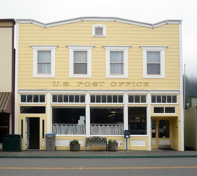

Property Detail
536 Main St
Eureka-Arcata, CA
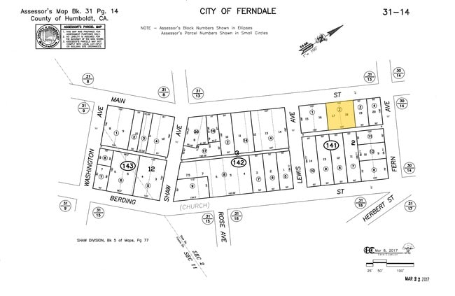
L2 B3 /SHAWS DIVISIONDIVISION-FERN604450000A C 86C 00000000 N
031-143-002-000
Humboldt
Storebuilding
California
C-2-D
2
C and X Area of minimal flood hazard, usually depicted on FIRMs as above the 500-year flood level.
0.12 AC
2024
California North Rural Area
2025
Other Market Areas
011200
NEARBY LISTINGS FOR SALE OR LEASE
-
-
View all Ferndale listings for sale on LoopNet.com
DEMOGRAPHICS near 536 Main St
1 mile
3 mile
5 mile
2025 Total Population
1,034
1,722
2,774
2030 Population
927
1,534
2,505
Pop Growth 2025-2030
(10.35%)
(10.92%)
(9.70%)
Average Age
45
45
45
2025 Total Households
445
731
1,146
HH Growth 2025-2030
(10.79%)
(11.22%)
(10.12%)
Median Household Inc
$65,516
$66,724
$68,047
Avg Household Size
2.30
2.30
2.40
2025 Avg HH Vehicles
2.00
2.00
2.00
Median Home Value
$654,514
$703,260
$667,391
Median Year Built
1949
1954
1959
Nearby Places
Map Layers
Map Styles
 Street
 Aerial
Layers
 Traffic
 Biking
Places
Listings with unknown addresses are not visible on the map
- Restaurants
- Banks
- Shops
- Fitness
- Groceries
PUBLIC TRANSPORTATION
AIRPORT
California Redwood Coast-Humboldt County
Drive
Walk
Distance
California Redwood Coast-Humboldt County
54 min
36.1 mi
Freight Ports
Port of Coos Bay, OR
Drive
Walk
Distance
Port of Coos Bay, OR
321 min
236.2 mi
Nearby Properties
Address
Land Use
TOTAL SIZE
Lot Size
Zoning
Address
Land Use
TOTAL SIZE
Lot Size
Zoning
5.35 AC
C-AG-D-Q
Address
Land Use
TOTAL SIZE
Lot Size
Zoning
1.20 AC
C-1-D-Q
Address
Land Use
TOTAL SIZE
Lot Size
Zoning
5,362 SF
24.03 AC
U
Address
Land Use
TOTAL SIZE
Lot Size
Zoning
1.99 AC
A-E
Address
Land Use
TOTAL SIZE
Lot Size
Zoning
80.79 AC
AE-60/F,R
Address
Land Use
TOTAL SIZE
Lot Size
Zoning
20 AC
AE-60/F,R
Address
Land Use
TOTAL SIZE
Lot Size
Zoning
77 AC
AE-60/F,R
Address
Land Use
TOTAL SIZE
Lot Size
Zoning
87 AC
AE-60/F,R
Address
Land Use
TOTAL SIZE
Lot Size
Zoning
174 AC
AE-60/A,F
Address
Land Use
TOTAL SIZE
Lot Size
Zoning
38.50 AC
AE-60/F,R
Address
Land Use
TOTAL SIZE
Lot Size
Zoning
570 AC
AE-60/W,F
Address
Land Use
TOTAL SIZE
Lot Size
Zoning
2,172 SF
23 AC
AE-60/F,R
Address
Land Use
TOTAL SIZE
Lot Size
Zoning
74.06 AC
Address
Land Use
TOTAL SIZE
Lot Size
Zoning
1,650 SF
50.90 AC
AE-60/F,R
Address
Land Use
TOTAL SIZE
Lot Size
Zoning
30 AC
AE-60/F
Address
Land Use
TOTAL SIZE
Lot Size
Zoning
1,440 SF
40 AC
AE-60/F;AE
Address
Land Use
TOTAL SIZE
Lot Size
Zoning
6,111 SF
1.10 AC
C-2-D
Address
Land Use
TOTAL SIZE
Lot Size
Zoning
69 AC
AE-60/F,R
Address
Land Use
TOTAL SIZE
Lot Size
Zoning
93.43 AC
AE-60/F,R
Address
Land Use
TOTAL SIZE
Lot Size
Zoning
84.86 AC
AE-60/F,R
Address
Land Use
TOTAL SIZE
Lot Size
Zoning
3,014 SF
127.62 AC
AE-60/F,R
Address
Land Use
TOTAL SIZE
Lot Size
Zoning
0.26 AC
C-2-D
Address
Land Use
TOTAL SIZE
Lot Size
Zoning
8,091 SF
0.44 AC
C-2-D
Address
Land Use
TOTAL SIZE
Lot Size
Zoning
3,275 SF
55 AC
AE-60/F,R
Address
Land Use
TOTAL SIZE
Lot Size
Zoning
0.28 AC
R-1-D
Address
Land Use
TOTAL SIZE
Lot Size
Zoning
2,144 SF
34 AC
U
Address
Land Use
TOTAL SIZE
Lot Size
Zoning
0.09 AC
C-2-D
Address
Land Use
TOTAL SIZE
Lot Size
Zoning
33 AC
AE-60/F,R
Address
Land Use
TOTAL SIZE
Lot Size
Zoning
38 AC
AE-60/F,R
Address
Land Use
TOTAL SIZE
Lot Size
Zoning
3,040 SF
68.10 AC
AE-60/F,R
The World's #1 Commercial Real Estate Marketplace
Connect with us
© 2026 CoStar Group
The information above has been obtained from sources believed reliable. While we do not doubt its accuracy we have not verified it and make no guarantee, warranty or representation about it. It is your responsibility to independently confirm its accuracy and completeness. Any projections, opinions, assumptions, or estimates used are for example only and do not represent the current or future performance of the property. The value of this transaction to you depends on tax and other factors which should be evaluated by your tax, financial, and legal advisors. You and your advisors should conduct a careful, independent investigation of the property to determine to your satisfaction the suitability of the property for your needs.