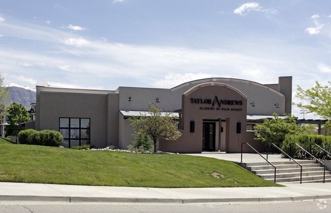
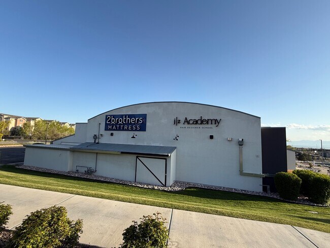
Property Record
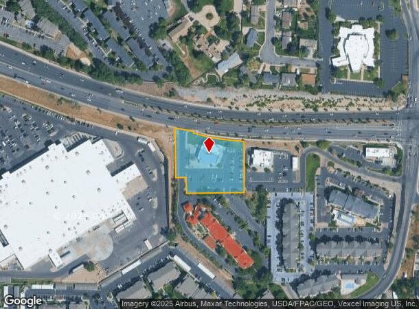
539 W University Pkwy, Orem, UT 84058

Current Lease Availabilities
NEARBY LISTINGS FOR SALE OR LEASE
Property Detail
539 W University Pkwy
Salt Lake City
Amd. Lake Ridge Development Sub
Provo-Orem, UT
PART LOT 5, PLAT B, AMD. LAKE RIDGE DEVELOPMENT SUB DESCRIBED AS FOLLOWS:; COM S 680.17 FT & W 703.44 FT FR N 1/4 COR. SEC. 27, T6S, R2E, SLB&M.; ALONG A CURVE TO R (CHORD BEARS: N 83 DEG 49 41 W 153.55 FT, RADIUS = 2939.43 FT); N 73 DEG 51 38 W 70.4
45-252-0010
Utah
Storebuilding
Utah
2024
5
2025
1.64 AC
001201
Utah County
8,576 SF
DEMOGRAPHICS near 539 W University Pkwy
1 Mile
3 Mile
5 Mile
2024 Total Population
18,439
131,130
238,311
2029 Population
21,540
153,431
278,216
Pop Growth 2024-2029
+ 16.82%
+ 17.01%
+ 16.74%
Average Age
31
31
31
2024 Total Households
5,460
40,208
73,481
HH Growth 2024-2029
+ 17.18%
+ 17.52%
+ 17.25%
Median Household Inc
$66,966
$70,459
$67,326
Avg Household Size
3.00
3.10
3.10
2024 Avg HH Vehicles
2.00
2.00
2.00
Median Home Value
$438,262
$424,739
$442,446
Median Year Built
1993
1990
1988
Nearby Places
- Restaurants
- Banks
- Shops
- Fitness
- Groceries
PUBLIC TRANSPORTATION
COMMUTER RAIL
DRIVE
WALK
Distance
5 min
2.1 mi
DRIVE
WALK
Distance
8 min
4.9 mi
AIRPORT
Provo Municipal
DRIVE
WALK
Distance
Provo Municipal
13 min
7.5 mi
Nearby Properties
Address
Land Use
TOTAL SIZE
Lot Size
Zoning
Address
Land Use
TOTAL SIZE
Lot Size
Zoning
1,744,846 SF
19.25 AC
Address
Land Use
TOTAL SIZE
Lot Size
Zoning
206,178 SF
16.64 AC
Address
Land Use
TOTAL SIZE
Lot Size
Zoning
1,003,185 SF
9.57 AC
Address
Land Use
TOTAL SIZE
Lot Size
Zoning
623,237 SF
14.06 AC
Address
Land Use
TOTAL SIZE
Lot Size
Zoning
530,326 SF
8.14 AC
Address
Land Use
TOTAL SIZE
Lot Size
Zoning
222,763 SF
10.71 AC
Address
Land Use
TOTAL SIZE
Lot Size
Zoning
472,365 SF
15.90 AC
Address
Land Use
TOTAL SIZE
Lot Size
Zoning
736,672 SF
7.04 AC
Address
Land Use
TOTAL SIZE
Lot Size
Zoning
627,022 SF
9.16 AC
Address
Land Use
TOTAL SIZE
Lot Size
Zoning
349,971 SF
11.43 AC
Address
Land Use
TOTAL SIZE
Lot Size
Zoning
326,355 SF
15.12 AC
Address
Land Use
TOTAL SIZE
Lot Size
Zoning
310,818 SF
1.17 AC
Address
Land Use
TOTAL SIZE
Lot Size
Zoning
219,346 SF
2.20 AC
Address
Land Use
TOTAL SIZE
Lot Size
Zoning
323,674 SF
13.81 AC
Address
Land Use
TOTAL SIZE
Lot Size
Zoning
333,719 SF
11.99 AC
Address
Land Use
TOTAL SIZE
Lot Size
Zoning
430,273 SF
15.74 AC
Address
Land Use
TOTAL SIZE
Lot Size
Zoning
122,784 SF
12.46 AC
Address
Land Use
TOTAL SIZE
Lot Size
Zoning
245,657 SF
5.60 AC
Address
Land Use
TOTAL SIZE
Lot Size
Zoning
212,820 SF
12.90 AC
Address
Land Use
TOTAL SIZE
Lot Size
Zoning
401,381 SF
3.50 AC
Address
Land Use
TOTAL SIZE
Lot Size
Zoning
222,803 SF
18.48 AC
Address
Land Use
TOTAL SIZE
Lot Size
Zoning
268,060 SF
11.73 AC
Address
Land Use
TOTAL SIZE
Lot Size
Zoning
107,840 SF
0.98 AC
Address
Land Use
TOTAL SIZE
Lot Size
Zoning
139,462 SF
3.93 AC
Address
Land Use
TOTAL SIZE
Lot Size
Zoning
124,242 SF
9.33 AC
Address
Land Use
TOTAL SIZE
Lot Size
Zoning
266,887 SF
8.12 AC
Address
Land Use
TOTAL SIZE
Lot Size
Zoning
194,483 SF
10.66 AC
Address
Land Use
TOTAL SIZE
Lot Size
Zoning
155,726 SF
13.64 AC
Address
Land Use
TOTAL SIZE
Lot Size
Zoning
179,347 SF
13.55 AC
Address
Land Use
TOTAL SIZE
Lot Size
Zoning
300,810 SF
7.32 AC
The World's #1 Commercial Real Estate Marketplace
Connect with us
© 2025 CoStar Group
The information above has been obtained from sources believed reliable. While we do not doubt its accuracy we have not verified it and make no guarantee, warranty or representation about it. It is your responsibility to independently confirm its accuracy and completeness. Any projections, opinions, assumptions, or estimates used are for example only and do not represent the current or future performance of the property. The value of this transaction to you depends on tax and other factors which should be evaluated by your tax, financial, and legal advisors. You and your advisors should conduct a careful, independent investigation of the property to determine to your satisfaction the suitability of the property for your needs.