Property Record
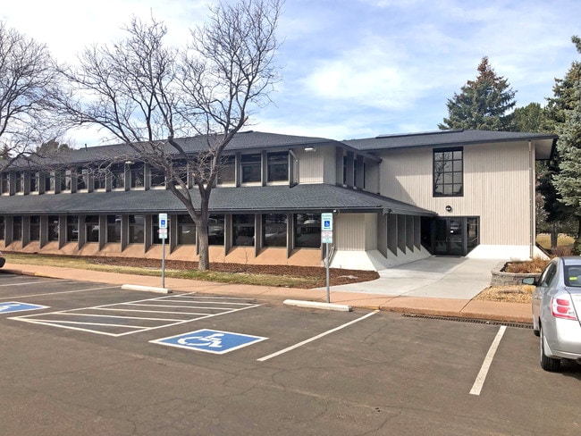
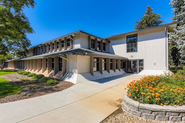
5420 S Quebec St, Greenwood Village, CO 80111

This Property Is For Sale
NEARBY LISTINGS FOR SALE OR LEASE
Property Detail
5420 S Quebec St
2075-16-2-28-013
Timberline Professional Center Condomini
Commercialcondominium
TOWNSHIP 5S MAPPLATB 524 MAPPLATP 55 SUBDIVISIONCD 062068 SUBDIVISIONNAME TIMBERLINE PROFESSIONAL CENTER CONDOMINIUMS UNIT 207 TIMBERLINE PROFESSIONAL CENTER CONDOMINIUMS AS PER CONDO DECLARATION RECORDED ON REC# D8043234
X
Arapahoe
08005C0457K
Colorado
2024
0.08 AC
2025
Greenwood Village
006712
Denver
992 SF
Denver-Aurora-Lakewood, CO
DEMOGRAPHICS near 5420 S Quebec St
1 Mile
3 Mile
5 Mile
2024 Total Population
10,829
95,281
288,728
2029 Population
10,940
95,324
293,349
Pop Growth 2024-2029
+ 1.03%
+ 0.05%
+ 1.60%
Average Age
40
41
41
2024 Total Households
5,685
41,627
126,077
HH Growth 2024-2029
+ 1.04%
+ 0.21%
+ 1.69%
Median Household Inc
$93,639
$100,284
$89,697
Avg Household Size
1.80
2.20
2.20
2024 Avg HH Vehicles
2.00
2.00
2.00
Median Home Value
$839,121
$693,375
$625,591
Median Year Built
2006
1981
1980
Nearby Places
Map Layers
Map Styles
 Street
 Aerial
- Restaurants
- Banks
- Shops
- Fitness
- Groceries
PUBLIC TRANSPORTATION
TRANSIT/SUBWAY
Orchard (E Line - Denver Regional Transportation District Light Rail (TheRide), F Line - Denver Regional Transportation District Light Rail (TheRide), G Line - Denver Regional Transportation District Light Rail (TheRide))
DRIVE
WALK
Distance
Orchard (E Line - Denver Regional Transportation District Light Rail (TheRide), F Line - Denver Regional Transportation District Light Rail (TheRide), G Line - Denver Regional Transportation District Light Rail (TheRide))
3 min
13 min
0.7 mi
Belleview (E Line - Denver Regional Transportation District Light Rail (TheRide), F Line - Denver Regional Transportation District Light Rail (TheRide), G Line - Denver Regional Transportation District Light Rail (TheRide))
DRIVE
WALK
Distance
Belleview (E Line - Denver Regional Transportation District Light Rail (TheRide), F Line - Denver Regional Transportation District Light Rail (TheRide), G Line - Denver Regional Transportation District Light Rail (TheRide))
8 min
14 min
0.7 mi
AIRPORT
Denver International
DRIVE
WALK
Distance
Denver International
33 min
26.6 mi
Nearby Properties
Address
Land Use
TOTAL SIZE
Lot Size
Zoning
Address
Land Use
TOTAL SIZE
Lot Size
Zoning
443,472 SF
7.88 AC
AMU
Address
Land Use
TOTAL SIZE
Lot Size
Zoning
389,502 SF
2.32 AC
T-MU-30
Address
Land Use
TOTAL SIZE
Lot Size
Zoning
344,259 SF
5.18 AC
Address
Land Use
TOTAL SIZE
Lot Size
Zoning
92,346 SF
4.22 AC
Address
Land Use
TOTAL SIZE
Lot Size
Zoning
331,620 SF
2.03 AC
T-MU-30
Address
Land Use
TOTAL SIZE
Lot Size
Zoning
313,812 SF
5.24 AC
GMC
Address
Land Use
TOTAL SIZE
Lot Size
Zoning
1,666,986 SF
11.12 AC
Address
Land Use
TOTAL SIZE
Lot Size
Zoning
470,605 SF
13.68 AC
B-8
Address
Land Use
TOTAL SIZE
Lot Size
Zoning
898,130 SF
89.50 AC
Address
Land Use
TOTAL SIZE
Lot Size
Zoning
637,459 SF
4.94 AC
AMU
Address
Land Use
TOTAL SIZE
Lot Size
Zoning
252,760 SF
3.63 AC
Address
Land Use
TOTAL SIZE
Lot Size
Zoning
959,756 SF
5.52 AC
PUD
Address
Land Use
TOTAL SIZE
Lot Size
Zoning
109,980 SF
1.99 AC
Address
Land Use
TOTAL SIZE
Lot Size
Zoning
453,595 SF
26.08 AC
PUD
Address
Land Use
TOTAL SIZE
Lot Size
Zoning
249,331 SF
4.93 AC
B-8
Address
Land Use
TOTAL SIZE
Lot Size
Zoning
191,152 SF
1.26 AC
S-MX-12
Address
Land Use
TOTAL SIZE
Lot Size
Zoning
359,561 SF
2.28 AC
B-8
Address
Land Use
TOTAL SIZE
Lot Size
Zoning
186,993 SF
16.22 AC
Address
Land Use
TOTAL SIZE
Lot Size
Zoning
129,234 SF
0.95 AC
T-MU-30
Address
Land Use
TOTAL SIZE
Lot Size
Zoning
313,836 SF
5.90 AC
B-8
Address
Land Use
TOTAL SIZE
Lot Size
Zoning
372,593 SF
5.61 AC
S-MX-12
Address
Land Use
TOTAL SIZE
Lot Size
Zoning
14,878 SF
34.55 AC
OS-B
Address
Land Use
TOTAL SIZE
Lot Size
Zoning
320,589 SF
33.33 AC
S-SU-F
Address
Land Use
TOTAL SIZE
Lot Size
Zoning
585,091 SF
5.42 AC
PUD
Address
Land Use
TOTAL SIZE
Lot Size
Zoning
396,041 SF
6.77 AC
B-8
Address
Land Use
TOTAL SIZE
Lot Size
Zoning
413,033 SF
4.33 AC
Address
Land Use
TOTAL SIZE
Lot Size
Zoning
355,464 SF
6.20 AC
B-8
Address
Land Use
TOTAL SIZE
Lot Size
Zoning
231,867 SF
19.33 AC
S-MX-3A
Address
Land Use
TOTAL SIZE
Lot Size
Zoning
332,114 SF
3.24 AC
GTC
Address
Land Use
TOTAL SIZE
Lot Size
Zoning
546,774 SF
8.81 AC
PUD
The World's #1 Commercial Real Estate Marketplace
Connect with us
© 2025 CoStar Group
The information above has been obtained from sources believed reliable. While we do not doubt its accuracy we have not verified it and make no guarantee, warranty or representation about it. It is your responsibility to independently confirm its accuracy and completeness. Any projections, opinions, assumptions, or estimates used are for example only and do not represent the current or future performance of the property. The value of this transaction to you depends on tax and other factors which should be evaluated by your tax, financial, and legal advisors. You and your advisors should conduct a careful, independent investigation of the property to determine to your satisfaction the suitability of the property for your needs.