Property Record
549 Route 30, Imperial, PA 15126
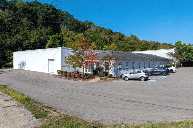


This Property Is For Sale
Current Lease Availabilities
Property Detail
549 Route 30
Pittsburgh, PA
A D BURNS PLAN 3 & 4 PTS 1-2 & 5 3.839 A LD
0917-D-00261-0000-00
ALLEGHENY
Warehouse
Pennsylvania
AE The base floodplain where base flood elevations are provided. AE Zones are now used on new format FIRMs instead of A1-A30 Zones.
261
2024
5.46 AC
2025
Parkway West Corridor
452000
Pittsburgh
NEARBY LISTINGS FOR SALE OR LEASE
-
-
-
-
-
-
1500 International Dr, Oakdale, PA 15071
Oakdale, PA 15071
Negotiable
100,000 - 200,000 SF
Industrial
-
-
View all Imperial listings for sale on LoopNet.com
DEMOGRAPHICS near 549 Route 30
1 mile
3 mile
5 mile
2025 Total Population
2,804
15,853
33,374
2030 Population
2,784
15,726
33,213
Pop Growth 2025-2030
(0.71%)
(0.80%)
(0.48%)
Average Age
41
41
41
2025 Total Households
1,183
6,634
13,620
HH Growth 2025-2030
(0.59%)
(0.87%)
(0.57%)
Median Household Inc
$99,459
$98,681
$105,519
Avg Household Size
2.40
2.30
2.30
2025 Avg HH Vehicles
2.00
2.00
2.00
Median Home Value
$276,122
$271,221
$279,404
Median Year Built
1980
1987
1983
Nearby Places
Map Layers
Map Styles
 Street
 Aerial
Layers
 Traffic
 Biking
Places
Listings with unknown addresses are not visible on the map
- Restaurants
- Banks
- Shops
- Fitness
- Groceries
PUBLIC TRANSPORTATION
AIRPORT
Pittsburgh International
Drive
Walk
Distance
Pittsburgh International
20 min
8.4 mi
Nearby Properties
Address
Land Use
TOTAL SIZE
Lot Size
Zoning
Address
Land Use
TOTAL SIZE
Lot Size
Zoning
69.68 AC
Address
Land Use
TOTAL SIZE
Lot Size
Zoning
66.86 AC
Address
Land Use
TOTAL SIZE
Lot Size
Zoning
2,274 SF
74.59 AC
Address
Land Use
TOTAL SIZE
Lot Size
Zoning
Address
Land Use
TOTAL SIZE
Lot Size
Zoning
26.75 AC
Address
Land Use
TOTAL SIZE
Lot Size
Zoning
19.63 AC
Address
Land Use
TOTAL SIZE
Lot Size
Zoning
42.64 AC
Address
Land Use
TOTAL SIZE
Lot Size
Zoning
Address
Land Use
TOTAL SIZE
Lot Size
Zoning
27.53 AC
Address
Land Use
TOTAL SIZE
Lot Size
Zoning
23.49 AC
Address
Land Use
TOTAL SIZE
Lot Size
Zoning
35.07 AC
Address
Land Use
TOTAL SIZE
Lot Size
Zoning
29.76 AC
Address
Land Use
TOTAL SIZE
Lot Size
Zoning
22.89 AC
Address
Land Use
TOTAL SIZE
Lot Size
Zoning
20.59 AC
Address
Land Use
TOTAL SIZE
Lot Size
Zoning
14.99 AC
Address
Land Use
TOTAL SIZE
Lot Size
Zoning
11.54 AC
Address
Land Use
TOTAL SIZE
Lot Size
Zoning
17.11 AC
Address
Land Use
TOTAL SIZE
Lot Size
Zoning
Address
Land Use
TOTAL SIZE
Lot Size
Zoning
7.74 AC
Address
Land Use
TOTAL SIZE
Lot Size
Zoning
13.20 AC
Address
Land Use
TOTAL SIZE
Lot Size
Zoning
15.86 AC
Address
Land Use
TOTAL SIZE
Lot Size
Zoning
13.31 AC
Address
Land Use
TOTAL SIZE
Lot Size
Zoning
1,344 SF
6.18 AC
Address
Land Use
TOTAL SIZE
Lot Size
Zoning
Address
Land Use
TOTAL SIZE
Lot Size
Zoning
42.67 AC
Address
Land Use
TOTAL SIZE
Lot Size
Zoning
Address
Land Use
TOTAL SIZE
Lot Size
Zoning
24.26 AC
Address
Land Use
TOTAL SIZE
Lot Size
Zoning
Address
Land Use
TOTAL SIZE
Lot Size
Zoning
7.96 AC
Address
Land Use
TOTAL SIZE
Lot Size
Zoning
4.38 AC
The World's #1 Commercial Real Estate Marketplace
Connect with us
© 2026 CoStar Group
The information above has been obtained from sources believed reliable. While we do not doubt its accuracy we have not verified it and make no guarantee, warranty or representation about it. It is your responsibility to independently confirm its accuracy and completeness. Any projections, opinions, assumptions, or estimates used are for example only and do not represent the current or future performance of the property. The value of this transaction to you depends on tax and other factors which should be evaluated by your tax, financial, and legal advisors. You and your advisors should conduct a careful, independent investigation of the property to determine to your satisfaction the suitability of the property for your needs.