Property Record
55 S 300 W, Hurricane, UT 84737
NEARBY LISTINGS FOR SALE OR LEASE
Property Detail
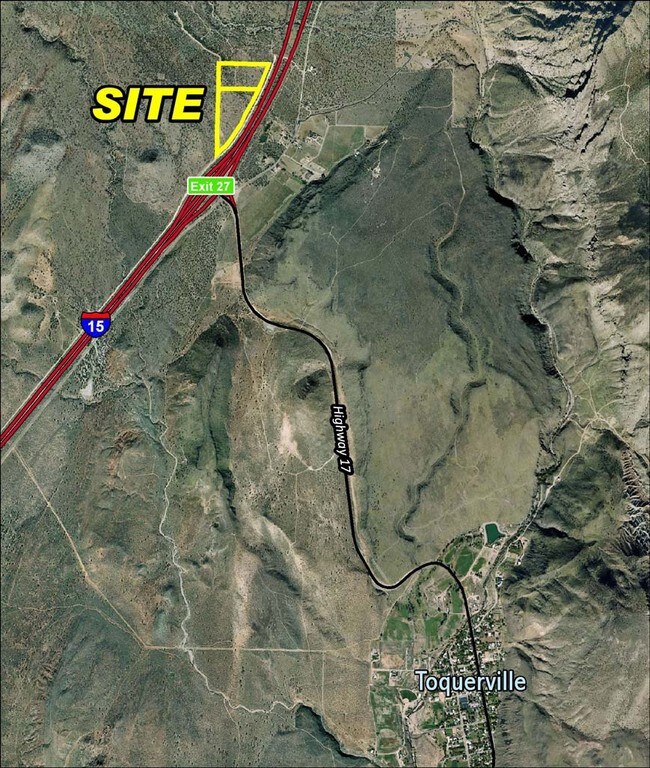
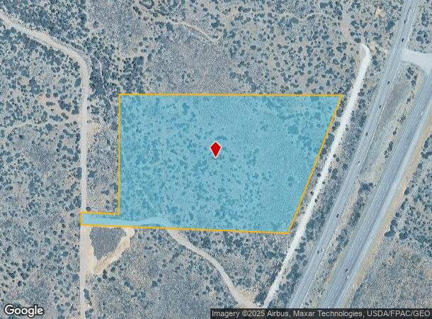
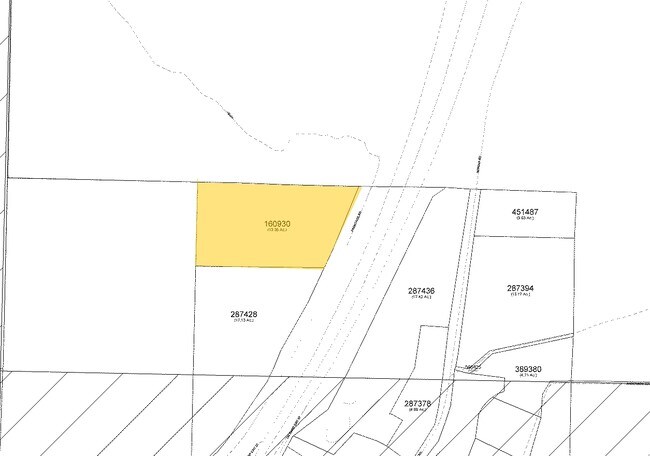
55 S 300 W
0160930
S: 22 T: 40S R: 13W BEG S89*5430 E 1320.62 FT & N0*1049 W 749.72 FT FM SW COR SEC 22 T40S R13W TO POB; TH N0*1049 W 573 FT; TH S89*5542 E 1149.68 FT; TH S21*0448 W 601.88 FT; TH S25*3352 W 48.12 FT; TH N87*5401 W 911.05 FT TO POB. LESS: BOUNDARY DESC
Commercialnec
Washington
X
Utah
49053C0595G
12 AC
2024
Cedar City & St George
2025
Other Market Areas
270100
St. George, UT
DEMOGRAPHICS near 55 S 300 W
1 mile
3 mile
5 mile
2024 Total Population
17
394
2,192
2029 Population
20
478
2,656
Pop Growth 2024-2029
+ 17.65%
+ 21.32%
+ 21.17%
Average Age
40
42
43
2024 Total Households
5
127
741
HH Growth 2024-2029
+ 20.00%
+ 21.26%
+ 21.46%
Median Household Inc
$112,500
$86,904
$78,034
Avg Household Size
2.40
3.00
2.90
2024 Avg HH Vehicles
3.00
3.00
3.00
Median Home Value
$399,999
$395,744
$397,924
Median Year Built
1994
1996
1996
Nearby Places
Map Layers
Map Styles
 Street
 Aerial
Transit
 Traffic
 Biking
Places
Listings with unknown addresses are not visible on the map
- Restaurants
- Banks
- Shops
- Fitness
- Groceries
PUBLIC TRANSPORTATION
AIRPORT
St George Regional
Drive
Walk
Distance
St George Regional
29 min
22.7 mi
Freight Ports
Port of Long Beach
Drive
Walk
Distance
Port of Long Beach
462 min
421.8 mi
Nearby Properties
Address
Land Use
TOTAL SIZE
Lot Size
Zoning
Address
Land Use
TOTAL SIZE
Lot Size
Zoning
12,819 SF
420.57 AC
A20
Address
Land Use
TOTAL SIZE
Lot Size
Zoning
27,033 SF
18.53 AC
Address
Land Use
TOTAL SIZE
Lot Size
Zoning
3,596 SF
200 AC
OST20
Address
Land Use
TOTAL SIZE
Lot Size
Zoning
3,537 SF
8.71 AC
Address
Land Use
TOTAL SIZE
Lot Size
Zoning
Address
Land Use
TOTAL SIZE
Lot Size
Zoning
360 SF
21.58 AC
Address
Land Use
TOTAL SIZE
Lot Size
Zoning
10,242 SF
2.80 AC
Address
Land Use
TOTAL SIZE
Lot Size
Zoning
5,692 SF
7.20 AC
Address
Land Use
TOTAL SIZE
Lot Size
Zoning
10 AC
Address
Land Use
TOTAL SIZE
Lot Size
Zoning
4,614 SF
0.57 AC
Address
Land Use
TOTAL SIZE
Lot Size
Zoning
7,626 SF
2.80 AC
Address
Land Use
TOTAL SIZE
Lot Size
Zoning
4,710 SF
0.61 AC
Address
Land Use
TOTAL SIZE
Lot Size
Zoning
3,480 SF
0.46 AC
Address
Land Use
TOTAL SIZE
Lot Size
Zoning
7,523 SF
0.70 AC
Address
Land Use
TOTAL SIZE
Lot Size
Zoning
5,012 SF
2.75 AC
Address
Land Use
TOTAL SIZE
Lot Size
Zoning
5,946 SF
1.69 AC
RE40
Address
Land Use
TOTAL SIZE
Lot Size
Zoning
2,775 SF
12.13 AC
Address
Land Use
TOTAL SIZE
Lot Size
Zoning
4,590 SF
0.92 AC
RE40
Address
Land Use
TOTAL SIZE
Lot Size
Zoning
3,840 SF
5 AC
A20
Address
Land Use
TOTAL SIZE
Lot Size
Zoning
2,428 SF
0.50 AC
Address
Land Use
TOTAL SIZE
Lot Size
Zoning
19.03 AC
Address
Land Use
TOTAL SIZE
Lot Size
Zoning
6,777 SF
0.97 AC
Address
Land Use
TOTAL SIZE
Lot Size
Zoning
4,152 SF
0.75 AC
Address
Land Use
TOTAL SIZE
Lot Size
Zoning
2,580 SF
8.23 AC
RE40
Address
Land Use
TOTAL SIZE
Lot Size
Zoning
3,885 SF
0.54 AC
The World's #1 Commercial Real Estate Marketplace
Connect with us
© 2026 CoStar Group
The information above has been obtained from sources believed reliable. While we do not doubt its accuracy we have not verified it and make no guarantee, warranty or representation about it. It is your responsibility to independently confirm its accuracy and completeness. Any projections, opinions, assumptions, or estimates used are for example only and do not represent the current or future performance of the property. The value of this transaction to you depends on tax and other factors which should be evaluated by your tax, financial, and legal advisors. You and your advisors should conduct a careful, independent investigation of the property to determine to your satisfaction the suitability of the property for your needs.